Monmouthshire County Council (MCC) is working on a strategic scheme to improve active travel provision between Monmouth and Wyesham. This scheme focuses on providing a new walking and cycling bridge, upstream of the Wye Bridge between Monmouth and Wyesham, with onwards routes to the centre of both communities. The new bridge will provide a main route to Monmouth town centre and secondary school for Wyesham residents, and across the Monmouth School campus, split between both sides of the river.
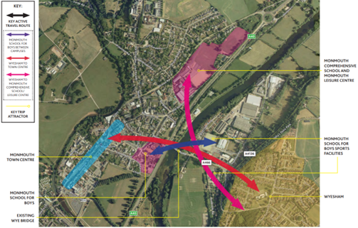
Image: Monmouth & Wyesham key active travel flows (route user survey 2019)
What is the change we expect to see?
Improved connectivity and accessibility for active travel trips in and between Monmouth and Wyesham
Improve actual and perceived levels of personal safety and security when walking and cycling
Promotion of sustainable travel as attractive and safe in Monmouth and Wyesham.
Identified issues for active travel between Monmouth and Wyesham
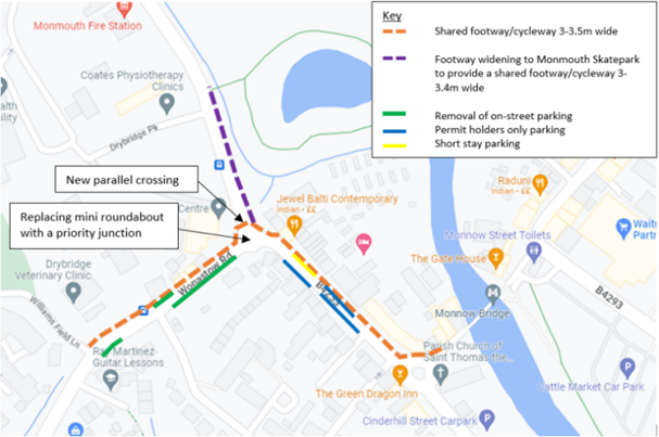
Monmouth’s historic Wye Bridge provides a vital link between Wyesham, the Forest of Dean and the Wye Valley, and the town of Monmouth and the A40, a strategic road link between South Wales and England’s Midlands. The roads that feed traffic across the bridge carry heavy vehicles and high traffic volumes, as this is the main river crossing for several miles in either direction. This impacts on routes either side of the bridge, and the scheme was eventually split into three sections, the Monmouth Wye Active Travel Bridge, Old Dixton Road and Wyesham Links.
The community of Wyesham suffers restricted and difficult access to the secondary school, shops and services in Monmouth because the existing infrastructure around the A40 and the River Wye effectively cut it off. The bridge is used daily by residents of Monmouth, Wyesham and the Forest of Dean to commute to work or school on both sides of the river. Local trips by vehicle must use a circuitous one-way system, in a network that is vulnerable to congestion, but the historic bridge does not provide a safe or pleasant route for short trips without a car, especially for those using wheelchairs and mobility scooters or walking with pushchairs or small children. Cycling is not permitted on the footway, but there is no provision for cyclists to transition between the underpass path and the road where needed.
The Wye Bridge in Monmouth is a Grade II listed building, protected for its historical and architectural significance. An assessment of the road bridge found it unsuitable as an active travel route. The pavement is narrow and heavy goods vehicles often mount the pavement due to the narrow carriageway, and its structure cannot be altered due to its heritage status.
Image: Heavy vehicle traffic on the Wye Bridge in close proximity to school children
The full scheme looks to:
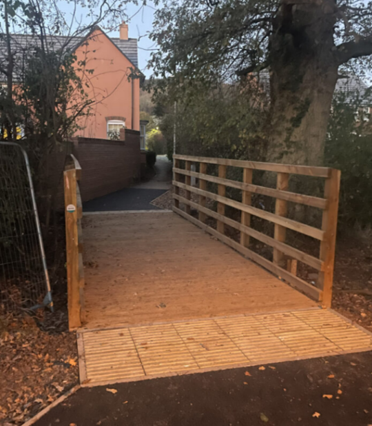
Construct a single-span 3.8m-wide walking and cycling bridge upstream of the existing Wye bridge with low-level lighting
Provide connecting routes in Wyesham and Old Dixton Road on either side of the active travel bridge
Provide a coherent, direct, safe, comfortable, and attractive walking and cycling link between Wyesham and Monmouth
Positively impact actual and perceived pedestrian, cyclist, and wheelchair user’s safety along and across the study area
Ecology net gain
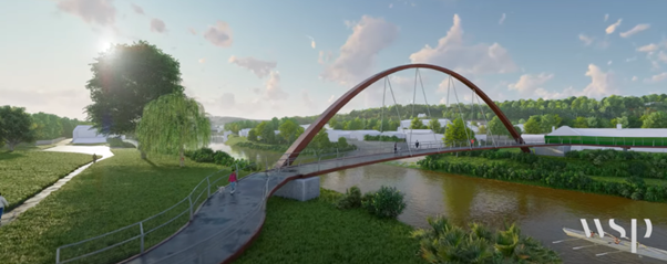
Monmouth Wye Active Travel Bridge
A separate pedestrian and cycle bridge over the River Wye in Monmouth was initially proposed as a recreational route. Following the Welsh Government’s Active Travel Act and recognition of this crossing’s function for active travel journeys as well as for recreation, the idea was developed under Monmouth Town Council’s Active Travel Group working party ‘The Bridge Group’, with stakeholders including Monmouth County Council, Monmouth School for Boys, Monmouth Comprehensive School, local Primary Schools, local rowing, cycling and walking clubs and Sustrans.
In 2019 a Weltag study was carried out to investigate the current issues and find potential solutions to them. The report suggested several options including, widening the current pavement, adding a cantilever footway to the existing bridge as well as a new walking and cycling bridge. The option of building a separate walking and cycling bridge upstream of the historic Wye bridge was selected as the best option to take forward based on scoring of the proposal’s potential positive impact on active travel and the local transport network, minimal negative impact during construction and on the nearby heritage bridge, value for money and deliverability.
Bridge scheme development
Image: Artists impression of Monmouth Wye Active Travel Crossing
Between 2020 and 2024, following the WelTAG study, MCC used Welsh Government’s Active Travel Fund to develop the design of the bridge and linking routes either side of the river, alongside the necessary planning permission, ecological studies and permissions, and land surveys as well as development of the Wyesham links and Old Dixton road schemes which form the onwards connections either side of the proposed bridge. Restricted funding and land issues has meant that progress has been slower than desired. In early 2024 the Wye Active Travel Bridge received planning permission with conditions.
A video of the proposed bridge can be seen here:
MCC used ATF Core Funding to maintain progress on this scheme in 2024-25. This included ecology surveys and monitoring, land negotiation, category II checks (independent examination of design) Early Contractor Involvement (ECI), and detailed design of the works and ‘pre-works’ (i.e. works needed to prepare the site, such as access routes and moving of utilities). The scheme has been put forward to the Cardiff Capitol Region’s Regional Transport Plan as one of Monmouthshire’s strategic Active Travel schemes.
Wyesham Links
Objectives of the Wyesham Links scheme
Provide a direct, coherent, comfortable and attractive walking and cycling network suitable for all users
Increase levels of sustainable access to education, employment health and other key services
Improve actual and perceived safety of vulnerable users
Increase the number of people walking and cycling between Wyesham and Monmouth town centre
Reduce car dependency and car use for short trips between Wyesham and Monmouth town centre through a modal shift
Reduce the negative impacts of transport on the natural and built environment
Identified Issues in Wyesham
High traffic volumes, with a significant proportion of heavy good vehicles, and high traffic speeds, related to the nearby dual carriageway and feeder roads, and lack of adequate provision for using alternative modes for short, local trips.
Lack of pedestrian crossing facilities and pinch points on the existing footway
Side road junctions are wide and require tightening of junction radii to reduce conflict with vulnerable road users
Dropped kerbs and tactile paving required at some side road junctions;
Lack of wayfinding and signage
Proposed Interventions – Wyesham Links
A series of studies of route usage and potential interventions in the Wyesham area led to the concept development of pedestrian only footway from the Mayhill Roundabout up the junction of Wyesham Road and Wyesham Avenue, with cycling provision to be made on road using the Quiet Streets principle, then, from Wyesham Avenue and Wyesham Road junction to Kymin View Primary School, a shared use facility utilising the potential generous footway widths along this section.
Image: Design concept plan for Wyesham Links scheme
Old Dixton Road scheme
Objectives of the Old Dixton Road scheme
The proposed active travel route will run from Monmouth Library along the A466 to where it joins with Old Dixton Road, east along old Dixton Road for circa 250m and thereafter heading through the subway under the A40 to Monmouth Rowing Club where it will join with an existing path that runs north east alongside the river.
Increase the number of active travellers in Monmouth by making the route along Old Dixton Road and from the Wye bank better suited and more attractive to pedestrians and cyclists
Improvements at key junctions and crossing points
Deliver environmental improvements for the area by encouraging mode shift from cars to active modes, reducing vehicle waiting, improving vehicle flows and infrastructure to make the route more attractive and reducing car traffic
Identified Issues in Old Dixton Road/ around Monmouth Comprehensive School
Congested, historic road infrastructure and narrow footways create an unattractive and incoherent route for active travel. Improvements have been made to the area with the construction of the new school and leisure centre buildings, but poor footway provision and restricted widths near the Nags Head pub still create issues for active travel along the route.
Image: Old Dixton Road Scheme route
Proposed Interventions – Old Dixton Road
The scheme proposes small-scale improvements to active travel provision along Old Dixton Road from Monmouth Library and Hub to the underpass to the River Wye, to maintain and increase levels of walking and cycling to the Comprehensive school, Leisure centre, other businesses and community facilities served by the route.
For more information on MCC’s work on active travel in Monmouth, please visit Monmouth – Monlife
As part of developing the wider Active Travel network for Caldicot and the Severnside area, Monmouthshire County Council (MCC) is proposing alteration of the design and traffic management for Woodstock Way in central Caldicot to improve active travel links to and from Caldicot School, Caldicot Leisure Centre and other local destinations. Subject to funding, later phases will improve further active travel links across the Severnside area of south Monmouthshire.
Woodstock Way scheme Construction
Phase 1 of this programme is to provide safer crossing points and efficiently manage traffic on Woodstock Way. Monmouthshire County Council have appointed contractors Centregreat to install the Woodstock Way active travel scheme phase 1. Construction work on the Caldicot Active Travel Scheme will commence on the 17th of March 2025. This scheme is funded through the Welsh Government’s Active Travel Fund.
The area covered by the scheme as consulted on has now been reduced to cover only the section of Woodstock Way from Mill Lane junction to the crossing at Aldi. This change is due to unforeseen circumstances that have affected the scheme and programme of works. It has been necessary to narrow the scope of the current construction works programme to ensure that remodelling of the junction and construction of safer crossings is achieved.
We are concurrently working on connecting schemes across Severnside, and plan to follow this scheme with active travel improvements to Mill Lane, which leads from Woodstock Way to Caldicot School entrance, the leisure centre and Park & Stride car park, Durand Primary School and homes in south-east Caldicot.
These proposals are developed in response to local issues and needs that have been identified by the County Council and other local organisations. There is a need for safer routes and crossing points for walking and cycling, with better management of traffic speeds, congestion and hazardous parking, particularly during drop off and pick up times, with the aim to improve the safety and quality of the environment for local people and for those travelling around Woodstock Way.
We aim to make it easier to make short, local trips by sustainable and active modes. Walking, wheeling and cycling to destinations (also known as Active Travel) can have a positive impact on physical and mental health, ability to learn and concentrate, and open up affordable access to local shops and services, employment, education and cultural destinations, and public transport connections. See more here Caldicot – Monlife
Consultation
Historic consultation of local stakeholders highlighted risks and barriers to active travel in the Caldicot School and Woodstock Way area, resulting in the design of the Woodstock Way active travel scheme. A consultation on the detailed design of phase 1 was held 27th August – 25th September 2024. Some details of the design were adapted in response to consultation responses.
Woodstock Way Active Travel Consultation, August-September 2024
A total of 72 people examined the proposals and responded to our consultation, either at the in-person event on the 25th of September 2024, or through the online survey, which was online between the 27th of August and the 25th of September 2024.
In addition to the online survey accessible to the general public, a slightly amended version of the survey was distributed to students of Caldicot School, and 183 school survey responses were received.
From the school survey: All of the proposed options received an overwhelmingly positive response, with more students thinking that the proposed changes would have a positive rather than a negative effect. Especially the redesign of Woodstock Way and the proposed crossing points at the Mill Lane junction received a majority of responses to say that these changes would have a positive effect.
From the public survey: Overall, 63% of respondents ‘agreed’ or ‘strongly agreed’ that the footway surfacing around Woodstock Way was substandard. 53% of respondents ‘agreed’ or ‘strongly agreed’ that crossings in the area were substandard. Just over 30% of respondents said that they felt unsafe walking through the area currently due to the substandard infrastructure or the speed and volume of motorised vehicles and 32% of respondents said that the improvements would make them feel safer and more comfortable using Woodstock Way.
Almost 14% of respondents said that the improvements would make them change their current transport mode.
The positive comments about the scheme included that providing a crossing at the Woodstock Way and Mill Lane junction would be an improvement, especially for school children trying to cross at this location. Several respondents referred to problems associated with the current situation at school drop-off and pick-up times.
Some respondents thought that the redesign of Woodstock Way would have negative rather than positive consequences. There was concern from some about the need for the scheme and its funding, the potential for conflict between path users, the impact on resident parking, and the possibility of traffic congestion or loss of road width. We will address these concerns through the detailed design, applying best practice and analysis of the impact to the local setting. Please see the feedback section below for further details.
Feedback themes
In total, 57 qualitative comments were received during the wider public consultation, and 30 further qualitative comments were received from school students. The table below summarises the qualitative comments under thematic headings and provides a response to identified concerns.
Feedback theme from public consultation survey
Quantum of Feedback
Our response
The scheme is not needed
12
The scheme seeks to improve active travel routes serving Caldicot School and the Caldicot Leisure Centre to provide a cohesive network of routes that will integrate and compliment other active travel and regeneration schemes in Caldicot. This scheme is needed to improve the safety of Woodstock Way and sustainably meet the travel needs of people in the area. It is designed to address multiple issues, in a way that is cost-efficient, more holistic and less disruptive than tackling them individually. Monmouthshire County Council (MCC)’s business case for this scheme has secured funding and has shown that it meets the aims of the Welsh Government’s Active Travel Fund.
The scheme will not encourage active travel
2
The scheme addresses issues along Woodstock Way which have been identified through the business case, such as safety concerns over crossing points, insufficient footway widths, and poor surface quality. These issues are likely to deter potential walkers, wheelers, or cyclists who would use active travel if these issues were resolved. (47% of respondent said the scheme would encourage them to walk wheel or cycle).
The money should be spent on other things
6
The money for the development and construction of this scheme has been obtained from the Welsh Government’s Active Travel Fund. This is Welsh Government money which is ring-fenced to fund the development and implementation of active travel schemes. This fund cannot be used for any other purposes.
I am concerned about disruption caused by construction
2
MCC will award construction of the scheme to a contractor based on quality and price elements. The quality elements will contain detailed information on the construction methodology and phasing. The scoring awarded for the construction methodology will take into consideration the phasing employed by the contractor and the mitigation measures described by them. Impacts on local residents and access to private properties will be minimised as much as possible.
The scheme will increase congestion and make it more difficult to drive through Caldicot
7
The traffic impacts of signalising the junction were tested using a traffic signals model and existing pedestrian, cycle and vehicular movements through the junction at peak times. The results of the model show that the signalised junction is well within capacity with predicted maximum queue lengths of 4 vehicles and maximum delays of less than 1 minute per vehicle. The traffic impacts of signalising the junction are also likely to be reduced over time as a result of the active travel improvements encouraging people to switch from vehicles to walking, cycling and wheeling for short every day journeys. On-site observations and surveys show that the crossing movements are spread out across all arms of the junction as well as diagonally across Woodstock Way, confirming the need for an all-red traffic phase to cater for all pedestrians and cycle crossing movements. The traffic signals will also prevent vehicles from stopping in the mouth of the junction to let out school students. This currently happens causing further congestion and confusion and increasing the potential for accidents.
I am concerned about the impact on resident parking
3
Resident parking on Woodstock Way and Mill Lane will still be available along most of both streets. The only changes are occurring in close proximity to the Mill Lane junction, where double yellow lines will be extended along Woodstock Way to facilitate the operation of the signalised junction, improving visibility for drivers exiting from Mill Lane. Access to residential driveways on Woodstock Way and Mill Lane will be maintained.
I am concerned about shared use paths
3
The proposed improvements widen the footpaths to a minimum of three metres to provide shared pedestrian and cycle routes. There is insufficient width to accommodate segregated pedestrian and cycle facilities without impacting on the available road space for two-way vehicle flow and residents parking. Shared use paths have been used very successfully elsewhere in the county. The proposed shared use path is designed to be three metres wide, in accordance with Active Travel guidance. Illegal use of active travel paths by motorbike and e-scooter riders is a police matter and should be duly reported by calling 111.
The proposals will increase safety at the junction
5
Comments noted – thank you.
Additional crossings on Woodstock Way are needed and welcomed
16
Comments noted – thank you.
Consider building another path for school children to emerge onto Woodstock Way
3
This is part of a future phase of improvements as part of the wider Caldicot Education and Leisure Links project.
Why haven’t you considered removing the bus layby on Mill Lane?
1
Re-designing or removing the bus layby on Mill Lane were both considered as part of the long-listed options during WelTAG Stage 1 and the short-listed options during WelTAG Stage 2. However, concept design of these options showed that removing the bus layby would make it necessary to accommodate school buses elsewhere and all identified options were determined to offer reduced benefits in terms of number of spaces, proximity and accessibility to the school and increased construction costs.
The money should go towards funding a path to Magor/Rogiet/Undy
4
MCC is developing an active travel network for the growing population across the Severnside area, with a range of schemes and minor works being brought forward as funding and processes allow. This is called the Severnside Active Travel Scheme. The Caldicot Education and Leisure Links scheme Phase 1 scheme forms a key link in the Severnside Active Travel Scheme. More information can be found here: https://www.monlife.co.uk/outdoor/active-travel/caldicot/
This is different to previous proposals that went to consultation
1
The proposals for Woodstock Way have not changed significantly since the development of this option. Similar options for the Woodstock Way and Mill Lane junction and the widening of footways along Woodstock Way were presented during the public consultation in October 2022. The previous consultation did however ask for residents’ views on options that were being considered for the wider Caldicot Education and Leisure Links project.
Total unique comments
87
Phase 1 proposal overview
Caldicot Active Travel Education Scheme phase 1 will upgrade active travel paths and crossings along Woodstock Way to address issues of safety, path quality and congestion. The route improvements in this phase will connect to the wider Severnside Active Travel scheme in later phases. This section has been progressed with urgency because it is a major route to important local services, including Caldicot School, Gray Hill Surgery, Library and Leisure Centre. The area covered by the scheme as consulted on has now been reduced to cover only the section of Woodstock Way from Mill Lane junction to the crossing at Aldi.
Widening and resurfacing of the south side Woodstock Way footway from the Mill Lane junction to the crossing outside Aldi to make a 3-metre-wide shared use active travel path.
Installation of traffic lights with smart Toucan crossing facilities at the Mill Lane junction on Woodstock Way (by Gray Hill Surgery/ Caldicot School) to improve safety of traffic flows (vehicle and active travel). This includes three lateral crossings and a diagonal crossing from Norman Court to the Gray Hill/Caldicot School corner, to efficiently route the main flow of active travel traffic at peak times.
Narrowing and resurfacing of the south side footway of Woodstock Way from Durand Road to Mill Lane to – at minimum – a width of 1.5 metres. This will allow for widening of the opposite pavement.
Conversion of existing Puffin (signalised, pedestrian only) crossing outside Aldi to a Toucan crossing (signalised, walking and cycling).
Repositioning of Gray Hill Surgery bus stops (north and south side) eastwards along Woodstock Way, towards the pedestrian cut-through to the town centre, and away from the Mill Lane junction.
Upgrade of bus shelters to include information boards and green (sedum) roof
Removal of Aldi bus stop (south side) as the Gray Hill bus stop would be moved closer.
Signage to indicate traffic order to restrict Heavy Goods Vehicles from turning off Woodstock Way southwards onto Mill Lane (buses excepted).
Integration of tactile paving, dropped kerbs and signage throughout to improve route visibility, and access for disabled people.
Update of road markings.
Scheme drawings
To increase/decrease the size of the diagram, click the plus/’+’ and minus/’-‘ buttons in the bar at the top of the diagram window. To pan across and up/down, drag the sliders across the bottom and right-hand side of the diagram window. To open the diagram as a full page, click on the link below the diagram window. This will open the diagram in a new window, with the same increase/pan controls as described above. You can also download the image by clicking ‘Download’
Active Travel is a term used to describe walking, wheeling or cycling to a destination (also called “purposeful journeys”). It does not cover walking and cycling done purely for leisure although it could significantly enhance leisure activities by helping to link up networks. Active travel can be used to get to school, work, services and shops, or as one of several modes on a longer journey – for example, walking to the station to catch a bus or train. MCC’s active travel strategy focuses on journeys of three miles or less, which means improving walking and cycling infrastructure within communities, to make active travel the first natural choice for local journeys.
This scheme is funded through the Welsh Government Active Travel Fund, with funding awarded through a competitive bidding process. The funding obtained is scheme specific and cannot be spent on anything else.
Why is this scheme needed?
This scheme is needed to improve the safety of Woodstock Way and sustainably meet the travel needs of people in the area. It is designed to address multiple issues, in a way that is cost-efficient, more holistic and less disruptive than tackling them individually. Monmouthshire County Council (MCC)’s business case for this scheme has secured funding and seeks to maximise beneficial outcomes, through its strategic focus on active travel links to education and services, which in this area include Caldicot School, Leisure Centre, GP surgery, town centre and the Library/Hub.
Woodstock Way is a busy road where incidents of road danger involving Caldicot School students have been reported, and high traffic levels were observed during peaks causing congestion and safety concerns. The design of the area has an effect of how people travel, and the safety and attractiveness of that experience.
Our vision for the area is one where people have fair and convenient access to travel and transport options that are best suited to each trip, thereby improving connectivity and reducing the inequalities created by over-reliance on driving. Just over one fifth of adults in Monmouthshire have obesity, and more than one third do not do enough physical activity (source: British Heart Foundation 2023). It is generally recognised that walking and cycling paths need to be improved so that active travel (walking, wheeling and cycling for purposeful journeys) is an attractive and viable option, because that drives ‘modal choice’ (how people choose to travel) has a knock-on economic effect through consequences to our health and wellbeing, the environment and the quality of the local area.
To further understand the local travel and transport issues around Woodstock Way, we engaged with the primary local sources of traffic (of any mode, i.e. drivers and users of public transport and active travel). In 2020-2022 MCC commissioned Amey Consulting to study the area around Caldicot School and Leisure Centre. Conversations have been held with the Gray Hill surgery. Leisure centre users were consulted in 2020. Caldicot School students were consulted in 2021 on issues faced in commuting to school. Hazards and perceived danger were mentioned regularly, related to narrow pavements, heavy goods vehicle traffic, anti-socially parking and congestion during school pick-up and drop-off times. Students reported cramped and uneven pedestrian infrastructure and inaccessible pavements, with a lack of drop kerbs for wheelchair users even forcing them to use the road. Routes for cycling were also reported as inadequate and inconsistent. High traffic volumes make it difficult to cycle on the roads without segregated facilities. Crossing roads was another difficulty faced by Caldicot pupils, whether walking, wheeling or cycling, due to the volume and speed of traffic. The responses highlighted the need for a crossing on Woodstock Way at the corner of Mill Lane, as the nearest formal crossing is too far from the schools and does not serve active travel traffic from south and west Caldicot via Woodstock Way and Norman Court. Other factors that influenced the use active travel to get to school included time pressures, distance, weather conditions and the social aspect of commuting with peers.
From a study of the wider area, there are these specific issues on Woodstock Way:
Major safety concerns associated with students crossing at the junction in all directions. Poor visibility for drivers at Mill Lane junction due to over-parking on Woodstock Way
Insufficient footway width at the bus stop opposite Gray Hill Surgery, resulting in pupils blocking footway and spilling onto the carriageway
Footway width restriction and poor surface quality
Lack of necessary signage on Woodstock Way
Unpredictable crossing/parking was also observed, The consultants then prepared the proposed scheme as a Full Business Case, based on a range of evidence including interviews, observation, traffic surveys (including walking and cycling counts) and studies of the drainage, topography, land ownership, etc., to meet the objectives of the Council and the Active Travel Fund.
Image: Amey 2022 Site visit photos
This scheme has been designed around this consultation, which showed that safety and active travel infrastructure improvements are needed. Beyond safety and traffic management measures, high quality active travel routes are needed to support everyone, including students, to live active, healthy and connected lives.
Why has Woodstock Way been prioritised over other schemes?
A limited number of schemes can be progressed each year. Funding for this scheme was secured for this year, as research and design had reached the necessary stage for consultation and implementation. Woodstock Way was identified as a walking/wheeling and a cycling route in the ATNM (Welsh Government’s Active Travel Network Map) consultation in 2020-2021. It is a Very High Impact route on the Transport for Wales route impact tool, based on its central location and proximity to schools and other services, and this underlines the need to address the safety issues on the route as a matter of urgency.
We are building a network of routes throughout the County. Woodstock Way and its junction with Mill Lane has been prioritised as an active travel scheme because it is a main route to Caldicot School, with risks associated with school start and end times, but it’s also a town centre route to other destinations that attract traffic, be it by foot, wheeling, cycling, mobility scooter, bus or private vehicle. Destinations in the vicinity of this central road include Gray Hill Surgery, the town centre, bus stops, the leisure centre, Library/Hub and TogetherWorks, supermarkets, car parks and other local services, and there’s also through-traffic and recreational travel to consider.
The Woodstock Way scheme has ring-fenced and time-limited funding from the Welsh Government’s Active Travel Fund for financial year 2024-25. MCC successfully secured Welsh Government funding for this scheme by prioritising high-potential, central routes near schools, transport hubs and other services. This route has been prioritised because of the safety issues, and because it meets the criteria to maximise the impact of investment in active travel.
When will the route be constructed?
MCC is aiming to progress this project following public and stakeholder consultation, subsequent finessing of designs and a successful tender process.
How will the scheme be funded?
The scheme is to be funded through the Welsh Government’s Active Travel Fund. This funding stream is ringfenced to improve active travel infrastructure within larger settlements. Active travel infrastructure improvements support other policy areas, such as health and wellbeing, air quality, road safety, the Socio-economic Duty and placemaking/regeneration. The funding is administered by Transport for Wales on a competitive basis, where Monmouthshire County Council has bid for the funding to improve the Caldicot and wider Severnside area, creating safe and equitable access to sustainable transport for everyday journeys in Severnside.
The grant objectives of the Active Travel Fund, by which funding bids are assessed:
Encourage modal shift from car to active travel in isolation or in combination with public transport
Improve active travel access to employment, education, key services and other key traffic generating destinations
Increase levels of active travel
Connect communities
Have grants been secured for the proposals?
Funding has been secured in principle to complete the proposed works this financial year following a period of consultation and any following design amendments. This funding is time-limited and ring-fenced.
What about the rest of the area – does this mean other schemes in Severnside are de-prioritised?
MCC is developing an active travel network for the growing population across the Severnside area, with a range of schemes and minor works being brought forward as funding and processes allow. This is called the Severnside Active Travel Scheme. The survey of Caldicot School students in 2022 also highlighted the need for safe and practical active travel routes linking to Caldicot for the services that are shared across Severnside such as the secondary school, library and leisure centre. MCC is working through Welsh Government’s Active Travel Network Map and Active Travel Fund to futureproof travel and transport options for the residents of Caldicot, Crick, Caerwent, Portskewett, Undy, Rogiet and Magor, and support sustainable travel in and out of the area.
The Severnside active travel map (below) is indicative of the general areas of focus as we develop routes to central destinations in Severnside. The Woodstock Way scheme is shown on the map as 6. Education Scheme Phase 1 (red line). Routes are shown on the map for illustrative purposes and are not definitive of final network design. Other parts of overall Severnside active travel network are at earlier stages of development, and we will update the map as and when route alignments are established. Connections through Caldicot town centre will be the subject of a separate study.
Why Woodstock Way and not Newport Rd?
Newport Road was subject to a trial closure in the Autumn of 2022, scheme consultation following this trial indicated the strong desire for the road to remain open to 2-way through traffic. The space available within the carriageway does not allow for significant improvements to walking and cycling infrastructure along its length. A funding bid was submitted to redesign the road in light of the consultation results and with improvements for pedestrians where possible. Unfortunately this was not supported by the funding body.
During the progress on Newport Road, a separate scheme was underway looking at improvements around Woodstock Way and Mill Lane, including the improvement to pedestrian crossing facilities in the vicinity of the school. This scheme gained traction with the funders and is now what is presented here.
Will traffic be diverted onto Newport Rd?
Woodstock Way will remain open to 2-way traffic and the road widths will remain within standards. No impact is foreseen on motor vehicle traffic with the current 20mph speed limit.
How will this affect parking?
There will be localised road narrowing around the Woodstock Way/ Mill Lane junction at the new signalised crossing. Vehicle tracking analysis has established the feasibility of the planned road widths. To maximise parking within the redesign, and as a safety measure, a new Traffic Regulation Order (TRO) will restrict very large lorries from entering Mill Lane.
The standard restriction on informal parking in the vicinity of junctions, as per the Highway Code, will be maintained to allow safe sightlines around the crossings. Access to residential driveways on Woodstock Way will be maintained.
Woodstock Way is well served for visitor parking, with Woodstock Way MCC free car park and the Asda and Aldi car parks. In addition to supporting better use of capacity in the MCC car park by improving the entrance sightlines on Woodstock Way, the scheme is aimed at encouraging modal shift (converting some short car trips to walking or cycling) thereby reducing pressure on parking for those who need to drive.
What is a ‘shared use active travel path’?
A shared use path is a path for use by any mode of active travel, be it walking, wheeling or cycling, without any physical separating features or markings. The proposed shared use path is designed as three metres wide, in accordance with Active Travel Act guidance. Illegal use of active travel paths by motorbike and e-scooter riders is a police matter and should be duly reported by calling 111.
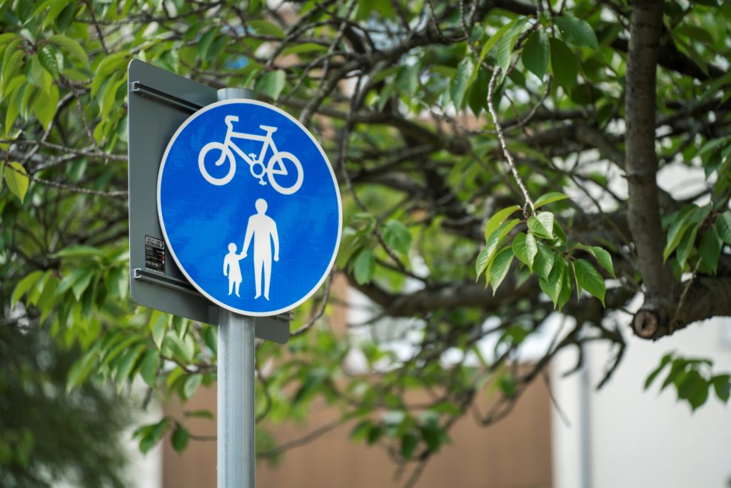
Image: Shared Use path roundel sign
This scheme includes widening sections of footways of Woodstock Way to accommodate a shared use active travel path that will be open for use for walking, wheeling (wheelchair, mobility scooter, kick scooter, etc.) and cycling. Specifically, the Woodstock Way north-side footway from the B4245 end of Woodstock Way to just beyond the Mill Lane junction, and south-side Woodstock Way footway from the Mill Lane junction to the crossing outside Aldi. Signage and tactiles will be installed to indicate shared-use designation. The routeing is designed around surveys of local active travel flows and traffic modelling.
Shared use paths allow for people walking, wheeling and cycling to use the same path, with enough width for it to be comfortable to walk with a buggy, use a mobility scooter, or accompany a child on a bike. An observation from other active travel schemes is that shared paths are conducive to considerate and slower-paced use: – where cyclists want to travel fast, they opt to use the road instead.
How does this scheme connect to the railway station?
The scheme is one part of a series of projects to connect through all of the Severnside communities. Projects are proposed to link into the railway stations, and we will progress these as resources and prioritisation allow.
How does this scheme connect to Mill Lane?
The Woodstock Way scheme is part of the Severnside Spinal Route. Building on the Woodstock Way scheme, designs are in development to (subject to funding and approval) continue the shared use active travel paths from Woodstock Way down Mill Lane to the entrance to the Leisure Centre car park, increasing capacity for active travel and creating a more direct Park & Stride route to Caldicot Comprehensive School from the Leisure Centre car park. This will address the safety and accessibility of routes to Caldicot School and Durand School, whilst improving the quality of place and green space along Mill Lane.
Won’t new traffic lights and crossings cause traffic jams?
The impacts of signalising the junction were tested using LinSig traffic modelling of observed pedestrian, cycle and vehicular movements through the junction at peak times. The results of the model show that signalised junction is slightly over capacity in the afternoon peak (105%), but this only results in a maximum queue length of less than 3 vehicles in the peak period and should be mitigated over time by modal shift encouraged by better active travel provision. The queue modelling should be compared to the current situation, which is a lack of safe crossings, or the suggested alternative, which is a zebra crossing and several informal crossings that will cause congestion differently (see below). It is possible that there will be a short-term peak in congestion after the scheme is constructed: this is typical of remodelled junctions, as it takes a few weeks for people to get used to changes to a route that they are familiar with.
The advantage of providing signalised crossings across all arms of the junction is that it caters for all pedestrian and cycle crossing movements in the most efficient way possible. On site observations and surveys show that the crossing movements are spread out across all arms of the junction as well as diagonally across Woodstock Way. It will also prevent vehicles from stopping in the mouth of the junction to let out pupils (this currently happens causing further congestion and confusion and increasing the potential for conflicts).
Advances in signal-controlled crossings will assist in the efficient control of traffic flows: Firstly, the new traffic signals will detect the presence of approaching vehicles on both the main line and the side road, as well as pedestrians and cyclists waiting at the kerb side or crossing the junction. The vehicle detectors will prioritise green-light time to the main road demands on Woodstock Way and will only stop main road traffic when there is a demand from traffic approaching from Mill Lane, or when the push button is pressed for the pedestrian/cycle crossing.
Secondly, detectors on the crossing facilities will detect the presence of pedestrians and cyclists and extend the crossing period time to suit. This means that traffic is only held for as long as needed and accommodates those who may need longer to cross (such as elderly/mobility impaired). Lastly, sensors on the kerbside will check the presence of people waiting to cross so, if someone presses the push button but walks away, the crossing phase will be cancelled allowing main line traffic to continue.
Wouldn’t a simple crossing, without the rest of the scheme, be quicker and cheaper?
If, instead of the proposed active travel scheme, a single zebra crossing was to be installed on Woodstock Way, this would only cater for one pedestrian crossing movement but may cause traffic to be stopped more often due to lack of provision for other crossing movements and the school peak period arrival and departure profile. The main pedestrian desire-line crossings (established in the preparatory traffic surveys) focus around the Mill Lane junction: a standalone zebra crossing in this location would either have to be placed too far from the junction to solve the safety issue, or fail safety audit and not be buildable, without the proposed measures surrounding it.
The proposed scheme addresses both current issues and future/growing problems with a secured source of funding. Road traffic danger has been highlighted, but the installation of a crossing on its own would not effectively address the systemic structural and behavioural legacy that underlies the current safety issue. Particularly at school start and end times, there is a clear need for improved route accessibility, traffic flow control (vehicular and active travel), wider paths and safer crossings serving several routes. In addition, there is the potential to address comprehensive issues to make active travel attractive enough to support even more people to leave the car at home for local trips. This scheme includes safe infrastructure for wheeling and cycling, vital to making active travel accessible, safe and practical. This scheme is designed to be cost-effective and ambitious in addressing multiple issues, from urgent questions of road safety to more general problems with public health and sustainability, in a way that is less disruptive than tackling them individually.
Why does the scheme have to be built to Active Travel standards?
This scheme is funded through the Welsh Government’s Active Travel Fund. This funding is ringfenced for active travel and, as such, the scheme must meet the specifications of the Active Travel Act guidance and evidence that it is focused on achieving the Wales Transport Strategy’s outcomes including modal shift, through the Welsh Transport Appraisal guidance (WelTAG) process.
Why do we need active travel routes in Caldicot?
Walking and cycling can be a useful, low-cost, efficient way to get about the town. Where students can walk to school, they are better able to concentrate, maintain good health and build social connections. MCC is working to support them, and everyone else too, to be more active because it benefits everyone’s health and wellbeing, as well as the environment and the community. We have seen an increasing proportion of short, local trips made by car: This creates a vicious cycle of congestion and feeling of risk that puts people off active travel. Some priority routes around schools, such as the junction of Woodstock Way and Mill Lane, urgently need to be re-designed to boost the safety, attractiveness and practicality of active travel for short, local trips.
Why not develop the King George V path?
The King George V path has been put forward as an alternative route connecting Church Road to Caldicot Station. It has not been prioritised for development or funding bids over Woodstock Way because of its location, and because it is narrow and isolated in places, though it remains on the Active Travel Network Map for addressing in the future. Woodstock Way, on the other hand, is adjacent to the Comprehensive School and there have been specific incidents of clashes between road and active travel traffic that have made this road the focus of the safety and quality design improvements. Woodstock Way is a wide route, with potential capacity for high volumes of active travel traffic.
Why are the bus stops being moved, and one bus stop being removed?
The Gray Hill Surgery bus stops (north and south side) will be repositioned eastwards, towards the supermarkets, Hub & Library and pedestrian cut-through to the high street, and away from the Mill Lane junction. This is designed to improve safety and visibility at the junction and better distribute the bus stops on Woodstock Way to bring the Gray Hill stops closer to the town centre. Studies of traffic flows in the area have shown that bus stops are currently too close to the junction which both creates risk and makes an unpleasant experience for those waiting when the junction is crowded. The Aldi bus stop (south side) will be removed as the Gray Hill bus stop would be 60 metres away, and the following bus stops are accessible at Caldicot Cross. The Woodstock Court bus stops will remain in the same place. The route of the public bus will remain the same. The bus shelters will be upgraded to include information boards and green (sedum) roof for access and environmental benefits.
Why doesn’t the scheme extend around the Asda corner?
Funding was provided to address problems around the school. It was assessed that this phase of the design should end at the Aldi crossing, where the main flow of active travel traffic will be heading towards the town centre, rather than continuing along Woodstock Way. Footway provision around Asda is already rollable and of a suitable width, so would not currently attract funding.
What about disabled access?
The accessibility of the route is central to the design and its funding, and particularly important to its proximity to Caldicot School and the Nurcombe Centre for students with additional learning needs (ALN), and the GP surgery. The current problems with local pavements, including a lack of drop kerbs, particularly affects the access, safety and comfort of people with disabilities, as highlighted in our 2022 consultation.
Paths will be designed and constructed according to the Active Travel Act guidance, ensuring that accessibility is considered throughout, both in the material infrastructure, signage and surfacing, and as part of a connected network. This means that design of the crossing facilities at the Mill Lane junction creates a more convenient and direct route, so that people aren’t forced to go a long way out of their desire-line along their route in a way that is particularly arduous for people with mobility restrictions and using wheelchairs.
We want to ensure that Woodstock Way active travel routes are accessible and attractive to everyone, including those with disabilities and reduced mobility, and/or travelling with children and/or baggage. Wider paths and clearer indication of routing are designed to reduce the potential of clashes between different traffic streams and improve the comfort and sociability of active travel. Safer, formalised street crossings with sensor-led smart phasing will further improve the accessible and intuitive function of the active travel paths.
How are people supposed to get to the town centre?
Existing walking/wheeling routes between Woodstock Way and the town centre will not be affected by this scheme. Improvements to connections into the town centre will be a later phase of development of the Severnside active travel network. There is currently rollable access from Woodstock Way to the town centre via the two routes through the Wesley Buildings (Bargain Booze/Davies & Son and Aldi/Dominos) and from the Library/Hub to the Cross, which will not be negatively affected by this scheme.
Will the scheme take trade away from the centre of Caldicot?
Good quality active travel infrastructure supports local shops and high streets by making it easier to get into the town centre for Caldicot and Severnside residents. We are working to increase the attractiveness and convenience of walking, wheeling and cycling to local shops as an alternative to driving out of town or to the supermarket. Access to active travel supports the regeneration of characterful, resilient and sustainable communities, for the health and wellbeing of current residents, a growing local population and for future generations.
This scheme will improve connections to existing walking/wheeling routes between Woodstock Way and the town centre, with later phases of the scheme linking-in Mill Lane and Caldicot station, to enable more local people to shop locally, benefiting from the financial savings and social opportunities that accompany better access to active travel.
Where cyclists want to commute past the town centre, this scheme will improve their safety on Woodstock Way, whether using the road or the active travel path. Caldicot town centre is pedestrianised. Mobility scooters are accommodated, and cycle parking is provided at either end of the pedestrianised area, giving competitive advantage to active travel over car parking in the area which can be enhanced by improving routes that connect to the town centre, such as Woodstock Way.
How has the consultation been promoted?
The consultation has been promoted via local poster distribution, as well as on the Monmouthshire County Council website, local newspapers, and social media. We have delivered information on the proposed double-yellow line extension to the residents that will be directly affected by this change. This approach is to ensure that, outside of the few households directly affected by the double-yellow line extension, we give equal treatment to the views of people who live in and use the area, regarding their need for safe and comfortable use of the space.
We are focusing on active travel links between Llanfoist and Abergavenny, with our route designed around a new active travel bridge crossing the River Usk between Merthyr Road and Castle Meadows, and associated links for safer, more attractive and direct sustainable routes into Llanfoist and Abergavenny.
Monmouthshire County Council has secured £10.4m from Welsh Government’s Active Travel Fund to develop the Abergavenny to Llanfoist Active Travel Scheme. Our construction partner for this scheme, Balfour Beatty, appointed under the SCAPE framework, will soon launch a scheme website – we will share the link here when it is available.
This scheme is a central priority for the development of Monmouthshire County Council’s Active Travel network, addressing the active travel severance point of the Merthyr Road bridge. This funding is bid for in a competitive national bidding process and once allocated is ring-fenced for this active travel project and cannot be spent on other projects, schemes or council services.
What is the change we expect to see?
Increase in active travel journeys in Abergavenny
Improved connectivity and accessibility for active travel trips in and between Llanfoist and Abergavenny
Improve actual and perceived levels of personal safety and security when walking and cycling
Promotion of sustainable travel as attractive and safe in Abergavenny and Llanfoist.
Video: Abergavenny Active Travel flythrough of scheme vision. Current construction is focused on delivering the active travel bridge.
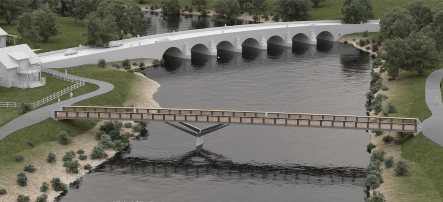
Active travel bridge
Objectives of the active travel bridge scheme
Provision of a new walking, wheeling and cycling bridge crossing on the Usk between Llanfoist and Abergavenny, downriver of the Usk Bridge (Merthyr Road). The bridge will become the main river crossing for active travel between Llanfoist and Abergavenny, as an alternative to using the narrow footway over the existing road bridge and encourage modal shift as a result.
Identified issues for active travel between Llanfoist and Abergavenny on Merthyr Road
Merthyr Road/Usk Bridge has long been identified as a severance point for active travel, and MCC has prioritised the development of this route. The existing bridge over the River Usk provides a very narrow footway on one side and does not cater for cyclists. The road bridge is a listed structure that carries a heavy volume of road traffic. There is currently little scope physically, or with its listed status, to make it more welcoming or safe for active travel. The overall aim is to provide an alternative river crossing for active travel, and ensure effective connections from the bridges (new and existing) into the town centre, allowing healthy travel between homes and key destinations such as schools, Nevill Hall and the town centre.
Proposed Interventions – Active travel bridge
This scheme will construct a new 3m wide walking, wheeling and cycling bridge across the River Usk, linking Llanfoist to Castle Meadows, Abergavenny. The bridge will be made of a steel beam construction with wooden cladding to ensure that it fits in with the natural surrounding area. Ramps will be constructed to connect the bridge to the paths on Castle Meadows and footway on Merthyr Road, Llanfoist.
Construction of the bridge is planned to commence in early 2026, with phased work continuing into 2027. Planning permission was granted for the active travel bridge in 2018 as DM/2018/00408, with permission granted in 2025 for non-material amendment to include steel beam construction – planning number DM/2025/00507.
Balfour Beatty, scheme construction partners, will soon launch a scheme website – we will share the link here when it is available.
Image – Active travel bridge on pier downriver of the road bridge
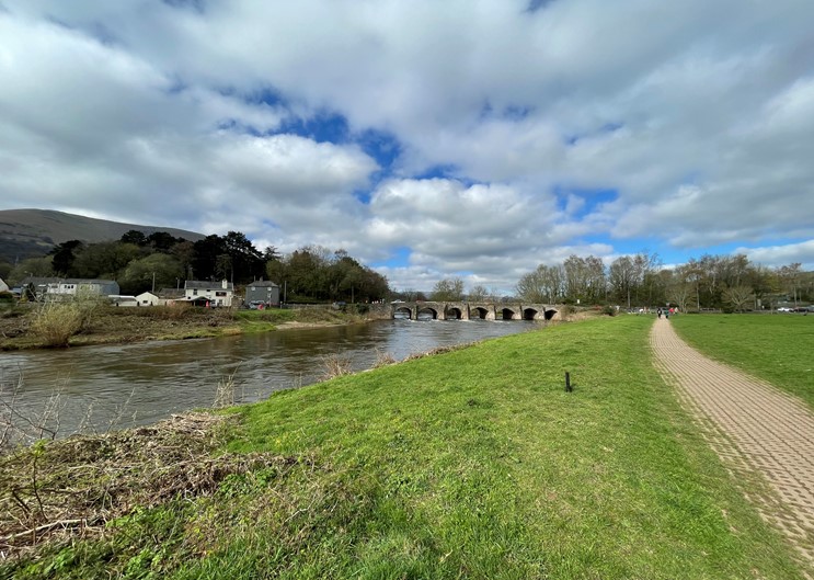
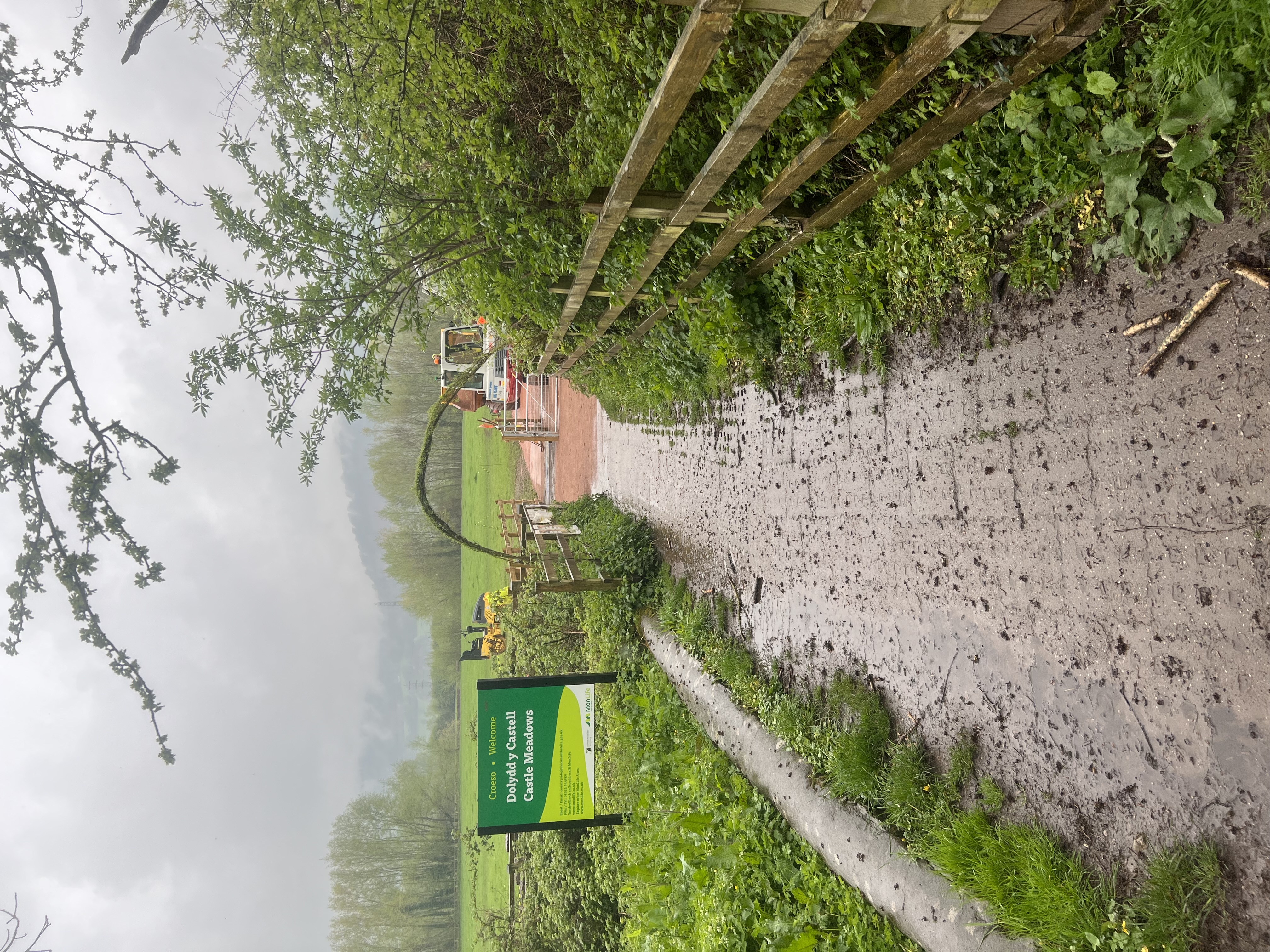
Castle Meadows
Castle Meadows and Ysbyty Fields are important leisure areas for the community and are crossed by Public Rights of Way (PRoW) and National Cycle Network routes 42 and 46. Improvements to the surfacing of routes on Castle Meadows can support pedestrians and cyclists travelling between Llanfoist and Abergavenny, in combination with the new active travel bridge.
As the scheme progresses further work will identify possible upgrades to paths within the meadows with the current funding available. The full extent of paths with potential for upgrade on Castle Meadows gained planning permission in 2023, as planning application DM/2022/01831.
Objectives of the Castle Meadows scheme
The objectives of the scheme have been derived through identification of key issues (as summarised above), and also according to the objectives set by the MCC and national policy. The objectives are as follows:
Ensure connections from the town centre through Castle Meadows to Llanfoist are accessible, to allow people the option of alternatives to driving this route.
Increase the number of pedestrians and cyclists using Castle Meadows for commuting and leisure purposes;
Make a positive contribution to air quality by promoting active travel
No significant adverse impacts on environmental sensitive receptors during construction and operation, protect and enhance the historic, built and natural environmental including landscape and settlement character of the area.
Identified Issues on Castle Meadows
Inaccessible and unattractive route across road bridge causes restricted access to Castle Meadows.
Grasscrete paths: The existing grasscrete paths are in a poor state of repair and don’t comply with active travel guidance for path surfaces. They are uncomfortable and difficult for wheelchair / mobility chair users to use.
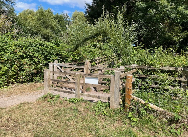
Restrictions at access points: A self-closing, latch-free gate has been trialled on the meadows for the last two years. The gate opens into the meadows, meaning cows cannot push the gate open and venture out. The existing wooden style kissing gates are restrictive to wheelchairs, mobility scooters, pushchairs, and cyclists gaining access to the meadows.
Proposed Interventions – Castle Meadows
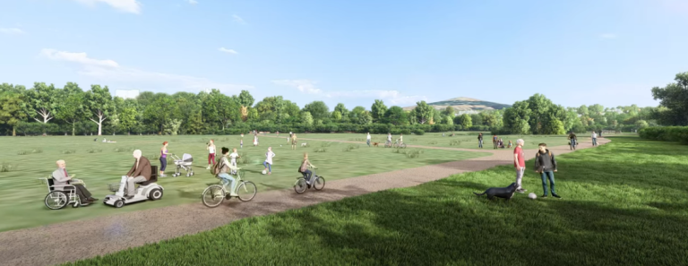
The WelTAG (Wales Transport Appraisal Guidance) study of this area looked at ways to improve the provision for active travel on Castle Meadows. Following this study, MCC sought planning permission to upgrade all of the main paths on Castle Meadows, pending funding availability and to allow flexible planning as the bridge plans were developed. MCC does not plan to upgrade all paths within the planning agreement, but is working to include some paths within the current scheme of works.
Image: Artists impression of Castle Meadows paths. N.B. MCC does not plan to upgrade all paths within the planning agreement as part of the bridge construction works.
Llanfoist Links
This phase looks at route improvements focused on the Llanfoist side of the River Usk and connections to the active travel bridge and Castle Meadows. Elements of this broad scheme will be included in the construction works, with other sections being brought forward as and when funding allows.
Objectives of the Llanfoist Links scheme
Improve access to local services, employment, and cultural facilities by Active Travel modes by improving connectivity between Abergavenny and Llanfoist.
Promote and facilitate healthier lifestyles by increasing the number of pedestrians and cyclists using Merthyr Road and The Cutting for commuting purposes.
Make a positive contribution to air quality by promoting active travel in MCC and supporting the reduction of Carbon Dioxide around the Abergavenny / Llanfoist area.
Introduce safe and accessible active travel links and remove conflicts between users around the ‘Waitrose’ Roundabout.
Provide a coherent, direct, and future-proof cycle route which connects with the existing and planned active travel infrastructure.
Identified issues in active travel between Llanfoist and Merthyr Road Abergavenny
The existing road network in the area is extremely busy, making the environment unappealing for pedestrians, cyclists, and those with mobility impairments. Analysis of 2011 Census data identified that 15% of drivers in the area travel less than 2km and 8% between 2km and 5km. Some of these trips could be accommodated by Active Travel modes if adequate Non Motorised User infrastructure would be provided.
There are currently no off-road cycle facilities: as such cyclists have to use the existing carriageway/s to travel.
A lack of adequate crossing facilities at the ‘Waitrose’ roundabout.
At sections of the scheme, footways are narrow and sub-standard, forcing pedestrians into close proximity to the carriageway and traffic.
There are significant perceived road safety issues, particularly along Merthyr Road between the Bridge Inn pub and ‘Waitrose’ roundabout.
The Cutting is recognised as low traffic and, as such, has the potential to serve as a link from Merthyr Road to Llanfoist, but the current link route behind Waitrose Petrol Station is narrow and overgrown at points.
Proposed Interventions –Llanfoist Links
The Wales Transport Appraisal Guidance (WelTAG) study of this area looked at ways to improve the provision for active travel links between Llanfoist and Abergavenny and proposed the interventions below. Some interventions included on this list will be rolled out as development and construction funding becomes available, with others to be re-investigated once the bridge is constructed.
The widening of the existing footway along the eastern side of Merthyr Road between the Bridge Inn pub and ‘Waitrose’ Roundabout, to accommodate a 3.5m wide shared (pedestrian and cycle) route. To accommodate this proposal, on-street parking at this location will be removed.
The provision of new crossing facilities across three arms of Merthyr Road.
The widening of the existing footway along the eastern side of Merthyr Road between Waitrose Roundabout and the Heads of Valleys Slip Road / Merthyr Road Roundabout to the south to accommodate a 3.5m wide shared (pedestrian and cycle) route.
The widening of the existing footway along the eastern side of Merthyr Road between the Heads of Valleys Slip Road / Merthyr Road Roundabout and Gypsy Lane, to accommodate a 3.5m wide shared (pedestrian and cycle) route.
The provision of improved more direct crossing points across Coopers Way and the eastern and western arms of the Heads of Valleys Slip Road / Merthyr Road Roundabout.
The widening of the existing footway along the back edge of the car park located to the immediate north of ‘Waitrose’ Roundabout, to accommodate a 3.5m wide shared (pedestrian and cycle) route.
The widening of the existing footway along the back of Waitrose Petrol Station between ‘Waitrose Roundabout’ and The Cutting Heads of the Valleys Road underpass, to accommodate a 3.5m wide shared (pedestrian and cycle) route.
The promotion as a ‘Quiet Way’ (through additional signage and road markings) of The Cutting (without impacting the existing access and parking arrangements) between The Cutting Heads of the Valleys Road underpass and Merthyr Road to the south.
The improvement of the existing The Cutting and Merthyr Road priority junction arrangement.
The Caldicot Links active travel scheme is designed to create an integrated network of shared use routes, linking existing and planned residential areas around east Caldicot to local destinations and public transport. The aim is to enable residents to use active travel for local trips and to connect to the wider Severnside active travel and public transport networks, through the construction of high quality and accessible routes for walking, wheeling and cycling.
Caldicot Active Travel Links scheme
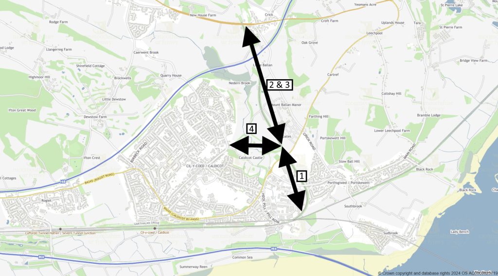
Caldicot Links scheme focuses on the north and east of Caldicot. The scheme is in three sections* (see plan below):
Phase 1: Running along the route of the old ex-Ministry of Defence Dinham railway line, from just south of the Cornfield at Portskewett, to level with Caldicot Castle Country Park.
Phases 2 & 3: From level with the country park northwards to Crick, crossing the northeast Caldicot RLDP sites.
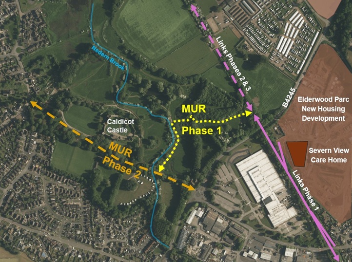
Phase 4 – Multi User Route: Running through Caldicot Castle Country Park connecting up with the Caldicot Links and the B4245 at its eastern end and linking into Church Road (and on to Caldicot Town Centre) at its western end.
*Sections of the scheme are being brought forward as funding and other constraints permit, i.e. not necessarily in numerical order.
Current progress
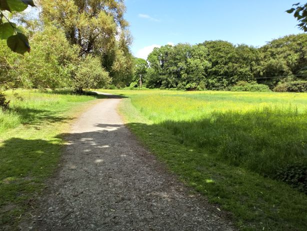
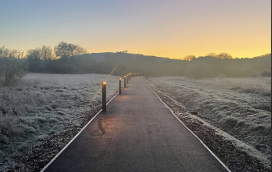
Phase 1: Construction completed providing an approximately 1km long tarmac surfaced shared route open to the public.
You are welcome to use this section of the new Caldicot Links active travel route for walking, wheeling, and cycling. Please note that this route is not being promoted as accessible to all users at this time and represents the first stage in delivering a complete connection from Portskewett to Caldicot.
Please note the following:
Caldicot Castle Country Park: There is currently no formal hard-surfaced path connecting this tarmac path to the Country Park tarmac service road. Users wishing to continue into the Country Park will need to use informal grass paths, which have uneven surfaces, slopes, and gates.
Elderwood Parc: There is no onward connection from the top of the ramp into Elderwood Parc due to the housing development still being under construction.
Picture: The new Caldicot Links Phase 1.
Phases 2 & 3: MCC appointed consultants have undertaken a study of the options available for developing the route north and east of the Country Park, considering the key opportunities and the constraints of this area. Further scheme progression is dependent on the future development of the RLDP sites adjacent to it and funding availability.
Phase 4 – Multi User Route (MUR): This phase has now been split into two sub phases (see plan below) to aid development.
MUR Phase 1 connecting up the northern end of the completed Links Phase 1 with the existing tarmac service road running through Caldicot Castle Country Park, via a new hard surfaced shared use path.
A public consultation on the scheme proposal took place throughout August 2025 which demonstrated good community engagement, interest and support for the MUR Phase 1. It also identified key elements that would improve the scheme for users, that have been incorporated into the design where possible.
A summary of the consultation results can be found here.
The scheme has completed its detailed design and gained planning permission, and is currently seeking all the remaining permissions required to enable its construction, planned for early spring 2026. Visualisations of the scheme design can be seen on a separate project webpage.
MUR Phase 2 running west-east through the country park from the western entrance off Church Road to the eastern entrance and connection with the B4245. Initial assessments have been undertaken but there is currently no funding available to progress the design.
Picture: Caldicot MUR phasingPicture: Proposed MUR phase 1 route alignment along line of existing gravel track
Why focus on north and east Caldicot?
This scheme looks to improve sustainable access to services, shops, and sites of education and employment around Caldicot. Trip generation related to the planned residential development to the east and north of Caldicot, as well as the need to mitigate congestion related to local employment sites and the newly toll-free Severn bridges gives extra impetus to the scheme, as this is an opportunity to make active travel the preferred mode for local trips for old and new residents alike. It also has added value of providing an attractive route for recreational activities and providing improved access to local community green spaces, such as Caldicot Castle and Country Park and the Cornfield Project, as well as to the Wales Coast Path and the wider Gwent Levels Landscape of Outstanding Historic Interest.
The phased Caldicot Links scheme focuses on the east of Caldicot, including linking to housing developments off Church Road and Crick Road, to ensure that current and future residents have accessible, healthy and sustainable transport options, to minimise and manage the road traffic impact of a growing population and to direct residents and visitors into the town centre as a local destination.
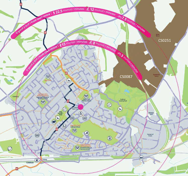
Below is a detail of our Active Travel Map for Caldicot, showing the time it would typically take to travel in the local area. The local development areas, shown in brown, will include parcels of green space (i.e. the indicated sites include areas that will not be built up):
What is active travel?
Active travel is a term used to describe walking, wheeling or cycling to a destination, which the Active Travel Act (Wales) 2013 calls “purposeful journeys”. It does not cover trips taken purely for leisure although it could significantly enhance leisure activities by helping to link up networks. Active travel can be used to get to school, work, services and shops, or as one of several modes on a longer journey – for example, walking to the station to catch a bus or train. Monmouthshire County Council (MCC)’s active travel strategy focuses on journeys of three miles or less, which means improving walking and cycling infrastructure within communities and between close-by settlements such as Caldicot, Portskewett and Crick, so that active travel can be the natural choice for local journeys. MCC also aims to improve active travel links to public transport, to support sustainable travel across the county.
How is the Caldicot Links scheme funded?
The Caldicot Active Travel Links and Multi-user routes project development and construction works to date have been funded by Welsh Government grants aimed at improvements to sustainable transport modes.
The Rogiet to Undy B4245 active travel scheme aims to improve journeys between Rogiet and Undy. Several route options have been examined and, whilst additional routes may be developed in the future, a proposed primary route consisting of a shared use active travel path adjacent to the southern side of the B4245 has been assessed to provide the shortest, most direct active travel route between Rogiet and Undy.
Following consultation on the General Arrangement drawings (below), Monmouthshire County Council is using Active Travel Fund core funding for detailed design (including the SAB* process) and land negotiation to progress the scheme towards construction.
*SAB – Sustainable Drainage Systems Approval Body – through which the drainage strategy is approved. The path design will include a swale to capture and manage rainwater runoff, as required with all new construction.
Scheme description
The current B4245 between Undy and Rogiet has no pavement provision. Previous studies along this route have highlighted the need for safe pedestrian and cycle provision, to link into Severn Tunnel Junction railway station and across the Severnside area.
Rogiet and Undy are just over a mile apart, a distance that could be covered using a mobility scooter in half an hour or cycled in less than ten minutes. An active travel route along this section of the B4245 will allow residents of both villages to benefit from the facilities and opportunities offered by their neighbouring villages, without needing access to a car.
Consultation results
219 people examined the proposals and responded to our consultation, either at the in-person event on October 4th 2023 or online. Rogiet Community Council and Magor Town Council submitted comments separately.
B4245 Rogiet-Undy active travel path (Phase 1)
96% of people consulted were ‘very-‘ or ‘quite supportive’ of the proposed Rogiet to Undy active travel path, which is as expected given that there is currently no direct, accessible link for active travel. Many urgently want to have the option of active travel and find existing provision inadequate. The vast majority said the proposed improvements would influence their modal choice for local trips.
Comments focused on the potential for the proposed active travel path to be a safe, accessible, practical, sustainable, healthy, and affordable option. It is seen as a much-needed link ‘for all’ between communities. There was concern from some about the proximity of the path to the B4245, the potential for conflict between path users, the path’s impact on local biodiversity and the possibility of traffic congestion or loss of road width. We will address these concerns through design, applying best practice and analysis of impact to the local setting. Please see the FAQ’s section below for further details.
This route is seen as a step in connecting Magor and Undy to Severn Tunnel Junction, Caldicot and further afield. A typical comment said: ‘This is a plan that will benefit the residents and visitors of the related areas, and promoting more environmentally friendly travel modes, e.g., combined of walking/cycling and train instead of driving.’
Station Road (Phase 2)
Over half of people consulted travel along Station Road to get to public transport (Severn Tunnel Junction railway station) and the majority frequently use the route for purposeful journeys. Most said that wider pavements and general improvements to the active travel infrastructure would encourage them to walk and/or cycle along Station Road, where currently more than three quarters of people consulted mainly drive along it.
Rogiet to Caldicot proposed AT route (Phase 3)
92% of respondents said ‘Yes’ to the question ‘Would you support Phase 3 Rogiet to Caldicot Active Travel route section?’
Active Travel is a term used to describe walking, wheeling or cycling to a destination (also called “purposeful journeys”). It does not cover walking and cycling done purely for leisure although it could significantly enhance leisure activities by helping to link up networks. Active travel can be used to get to school, work, services and shops, or as one of several modes on a longer journey – for example, walking to the station to catch a bus or train. Monmouthshire County Council’s active travel strategy focuses on journeys of three miles or less, which means improving walking and cycling infrastructure within communities and between close-by villages such as Rogiet and Undy, to make active travel the first natural choice for local journeys.
Why focus on the B4245 between Rogiet and Undy?
The need for improvements in this part of Monmouthshire was highlighted during Monmouthshire County Council’s Integrated Network Map submission to the Welsh Government in 2018. The existing options for active travel between Rogiet and Undy (approximately 1,700 and 4,000 inhabitants, respectively) are limited and inaccessible to various users, due to high traffic speeds and volume, and a lack of barrier-free and safe paths.
Several options for an active travel link between Rogiet and Undy have been examined and a proposed primary route consisting of a shared use active travel path adjacent to the southern side of the B4245 has been assessed to provide the shortest, most direct option.
The proposed route between Rogiet and Undy is an important link in the wider walking and cycling network. A short and direct active travel route will open up healthy, affordable and sustainable access to services, schools and job opportunities in the two villages, as well as connecting local people and visitors to the existing foot- and cycleways in the Severnside area, bus services along the B4245 and rail services to further afield.
Levels of active travel are lower in Rogiet and Undy compared to Monmouthshire as a whole. At the same time, the proportion of residents in the local area who drive a car or van is higher than Monmouthshire as a whole (Census 2021). The 2021 Census also indicated that Magor and Rogiet has a high proportion (63.7%) of working-age residents who are likely to travel regularly to commute and therefore would directly benefit from improved access to Caldicot and Severn Tunnel Junction Railway Station.
The Proposals
A study of potential options for active travel improvements in the area concluded that a three-metre wide, shared-use path to the southern side of the B4245 between Rogiet and Undy is the preferred option. Projects such as this one are usually progressed over several years from concept through to detailed design, following the Welsh Transport Appraisal Guidance or WelTAG (see below). Projects are then dependent on the approval of funding from bodies such as Welsh Government for the construction phase. We are currently at the detailed design stage of the process (WelTAG Stage 3).
As the preferred route is to be for active travel, the process has been based on the Welsh Government’s Active Travel Act Guidance that was published in July 2021. This includes the application of walking and cycling audit tools as well as standards that active travel routes should adhere to.
Option sifting
At the start of this project and in line with the Welsh Transport Appraisal process the project team developed a wide list of possible solutions, sufficient to be able to decide whether there are any scheme options worth pursuing and to select a short list of options for more detailed consideration. Options were shortlisted based on:
their ability to prevent, or solve the problem now and in the future;
their ability to meet the objectives set and improve the social, cultural, environmental and economic well-being of Wales;
their short- and longer-term impacts to deliver multiple benefits across the four aspects of well-being and maximise contribution to all seven well-being goals;
their deliverability; and
their robustness to uncertainty and potential to drive long lasting change.
WelTAG Process
The proposed scheme will seek approval and funding from the Welsh Government’s Active Travel Fund and has therefore been developed in line with the Welsh Transport Appraisal Guidance (WelTAG). The WelTAG process covers the complete lifecycle of a proposed intervention in the transport system from assessment of the problem, consideration of possible solutions and scheme design, through to implementation and project evaluation.
WelTAG studies are an essential part of major transport projects in Wales to help decide which are the most appropriate solutions to develop, and important in the support of bids to Welsh Government for funding grants to complete the works. WelTAG involves a series of project planning stages that follow the life of a project, programme or policy from early ideas to after it is completed. There are five WelTAG stages: Stages 1 and 2 of the project were completed in August 2022, and we are currently at WelTAG Stage 3.
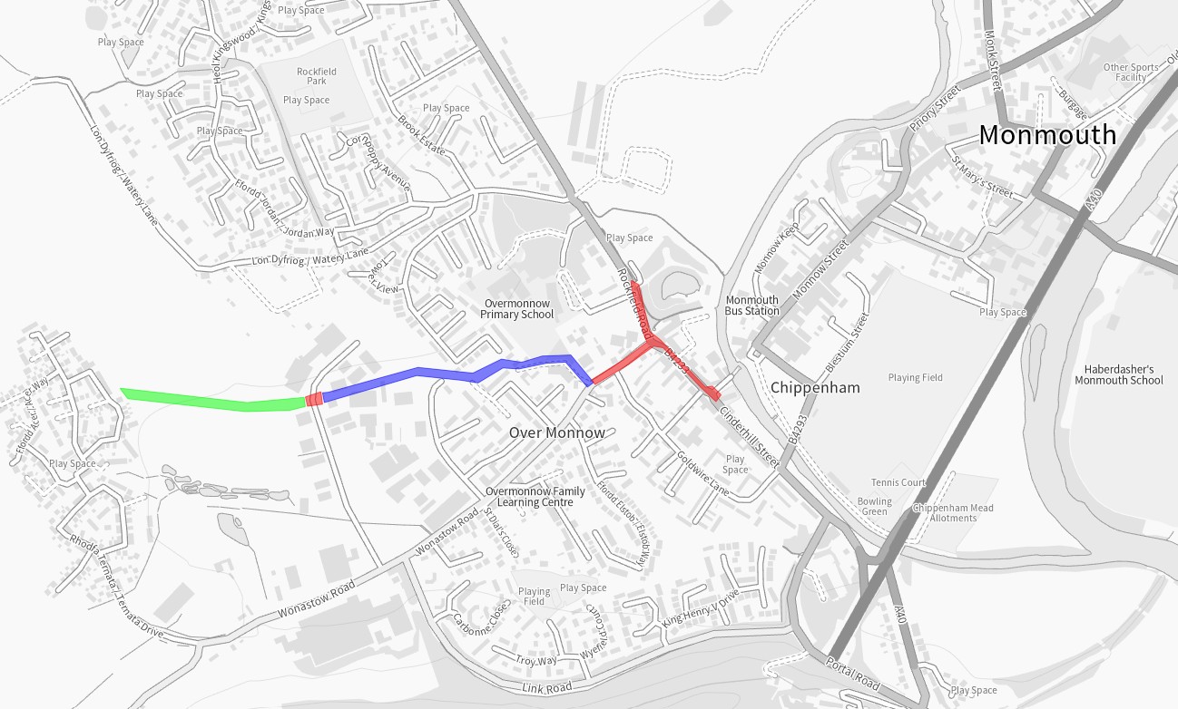
Future phases
The Rogiet to Undy route (phase 1, shown here as a green line) will complement other Severnside area proposed active travel improvements that Monmouthshire County Council are currently investigating as phases 2 and 3 of this project (red line and blue line, respectively). Phase 2 will focus of developing active travel improvements along Station Road in Rogiet to encourage walking and cycling journeys to Seven Tunnel Junction train station. Phase 3 will progress proposals to continue this route from the train station travelling east, to Caldicot, with the potential to link to National Cycle Network route (NCN) 4 at Station Road in Caldicot.
The successful completion of the WelTAG Stage 3, providing a full business case including detailed designs and delivery information, will allow us to apply for funding to move to WelTAG Stage 4 (construction phase).
How will the scheme be funded?
The route will be funded through Welsh Government grants aimed at improvements to sustainable transport modes.
Why is the route on the south side of the road?
The settlements of Undy and Rogiet are both predominantly on the south side of the B4245, this alignment of the route will reduce the number of road crossings required, improving the route coherence. In addition, an active travel route is better accommodated on the south side of the M4 underpass due to the cattle pass on the north side of the road.
Why is the route alongside the road?
Alternative route alignments were considered in the provisional studies for the route, these were discounted due to either public opinion or technical feasibility. The route alongside the road was seen to be a positive for personal safety due to the visible security of others passing.
This scheme aims to make it possible for a wider range of people to comfortably and safely reach local destinations using active travel. While cycling (as opposed to walking) makes up a higher percentage of active travel around Rogiet and Undy, overall active travel levels are low in the area.
The National Cycle Network section (NCN4) that joins Undy and Rogiet is an indirect route that is largely unlit and unsealed, making it either impractical or unsuitable for a diversity of people to use active travel between Rogiet and Undy.
The proposed shared use active travel path alongside the B4245, a wide single surface, would accommodate a wider range of active travel modes. The path is designed for use by pedestrians and people using wheelchairs and mobility scooters, as well as those on bikes and larger/adaptive cycles. Though some people currently cycle on this section of the B4245, the speed and volume of traffic – as well as the presence of heavy goods vehicles – makes it unlikely that most people will choose to cover this short, direct route by active travel unless a separated path is provided.
What is a ‘shared use active travel path’?
A shared use path is a path for use by any mode of active travel, be it walking, wheeling or cycling, without any physical separating features or markings. Cars and motorbikes are not permitted on a shared use path. The proposed shared use path is designed as three metres wide, with the exception of the section of the M4 overbridge where slight narrowing may be necessary. The route will be lit and separated from the road traffic.
Shared use paths are recommended in the Active Travel Act guidance for inter-urban roads such as the B4245 between Rogiet and Undy, where the number of users of different modes is unlikely to reach a level where separate provision – and the consequent environmental, land, materials and cost impact – would be justified. Routes with a wide single surface are better able to accommodate larger cycles, such as those used by disabled people, and people in wheelchairs. Shared use paths allow for flexible use depending on the time of day – for example, cyclists may be the majority group during the weekday peak, and pedestrians and those using mobility scooters during daytimes and at the weekend.
Shared use routes are designed to provide sufficient space so that cyclists can comfortably overtake groups of pedestrians and slower cyclists, in accordance with Active Travel Act guidance. Illegal use of active travel paths by people on motorbikes and e-scooters is a police matter and should be duly reported by calling 111.
How does this affect plans for a Magor & Undy Walkway station?
Monmouthshire County Council is supportive of plans for Magor and Undy Walkway Station as it will encourage and support active travel, help the modal switch from road to rail and lead to a reduction in carbon emissions and air pollution in the area. The meantime addition of an active travel route between Undy and Rogiet complements plans for a walkway station, offering the option of car-free trips and embedding the choice of active travel and sustainable transport in local people’s travel habits.
Is there enough space, will greenery be removed and will the road be narrowed?
The proposed active travel route will require the redesign of parts of the road and verge, and the acquisition of strips of land from private landowners. The current road width varies along this portion, the scheme will make the road a consistent width of six and a half metres, which is the current minimum width of the road.
Monmouthshire County Council’s land team is engaging with landowners to acquire the land required for the scheme. The relevant landowners have already been contacted by the ecology team who required permission to enter private land to carry out ecology surveys in preparation for this scheme.
Where necessary, verges, hedges and field boundaries will be re-designed, along with field accesses and walls. The redesign includes the translocation or replacement planting of hedges and trees. Ensuring that the scheme brings a net benefit to biodiversity is fundamental of Monmouthshire County Council and a requirement for Welsh Government funding of the scheme. The scheme will be appropriately assessed for ecological constraints and opportunities as part of the active travel project. Monmouthshire County Council’s Green Infrastructure team will work closely with the project team to ensure that impacts are minimised and opportunities are maximised to contribute towards nature recovery.
A complete and accessible active travel route from Kingswood Gate housing estate, Monmouth, to Monmouth town centre via Wonastow Road Industrial Estate, Overmonnow Primary School and Old Monnow Bridge, with onward connections to Bridges Community Centre, Monnow Vale Community Hospital, Rockfield Road car park (MCC) and Monmouth skatepark.
Provide a coherent, direct, comfortable, and attractive walking and cycling network from Overmonnow to surrounding communities, services, and facilities across Monmouth;
Increase levels of sustainable access to employment, health, education, and services;
Positively impact actual and perceived pedestrian, cyclist, and wheelchair user’s safety along and across the study area;
Support modal shift in Monmouth towards more sustainable forms of transport;
Reduce the negative impacts of transport on the natural and built environment.
Why were changes proposed?
The need for an improved route to Overmonnow Primary School was first recognised during Monmouthshire County Council’s Active Travel Integrated Network Map (INM) submission to the Welsh Government in 2018. Wonastow Road is an arterial route into the town and industrial area for vehicle traffic, but providing active travel routes in the area was challenging due to the legacy road layout, lack of footway and width in some sections, and a ditch/culvert that runs along the side of the road. A public right of way running between Kings Fee, Overmonnow, and St Thomas Road, Drybridge, offered a route away from sometime heavy vehicle traffic, but was a dirt path that was dark and inaccessible at times.
The housing development at Kingswood Gate has been one of the key drivers for changes being proposed, responding to local population growth by supporting modal shift and reducing pressure on local highway network. Walking, wheeling and cycling provision have a significant role to play in mitigating vehicle congestion, pollution, and health and wellbeing issues related to car-dependent lifestyles.
How was the scheme funded?
Funding for the various elements of this scheme has been granted from the Welsh Government Active Travel Fund, Safe Routes in the Communities (SRiC) fund as well as Section 106 monies from local developments.
Kingswood Gate path
Constructed 2025
The Kingswood Gate housing estate lies to the West of Overmonnow Primary School and was built circa 2016 and contains over 300 houses. The estate is connected by road to Monmouth by Wonastow Road. This road has poor pavement infrastructure with no scope to improve sections, high levels of HGV movement with the local industrial estate and a lack of active travel infrastructure. There is little potential to improve this corridor, due to the proximity of roadside culvert and neighbouring properties. The pedestrian route provided with the development of the estate was not sufficiently accessible or direct, and the Section 106 funding from the estate set aside for development of the preferred ‘desire line’ route across the Kingswood Gate meadow proved insufficient to complete the path. MCC therefore developed the path using successive rounds of funding from the Welsh Government’s Active Travel Fund (in addition to the Section 106) and, in 2025, £338,000 construction funding was secured by MCC from Welsh Government Safe Routes in Communities (SRiC) Fund.
This phase of the scheme has taken longer to complete than originally planned. Land ownership, changing the alignment of the Public Right of Way, sensitive ecology, flooding and funding cycles have all been factors in increasing the time the process took. The path was opened for use in November 2025.
The scheme includes:
A 3 metre-wide walking, wheeling and cycling path
A culverted crossing over the ditch from the meadow into Kingswood Gate estate (West end of the meadow)
Sustainable Urban Drainage (SUDs) features for ground water management along the length of the path
Biodiversity-friendly low-level lighting
Connection to the already constructed Wonastow Industrial estate crossing and the Williamsfield Lane path.
Walking and cycling data will be collected over the next couple of years to help build a picture and show trends of usage of the route. The Williams Field Lane section of the route saw increased use after its installation and continues to show good usage and obvious trends that people are using the route to go to and from school or a place of work. With the addition of the new Kingswood Gate section to this route it will allow even more people to choose to walk or cycle into Monmouth. The completed route connects directly to the crossing in Wonastow Industrial Estate, on to Williamsfield Lane and finally joins the Wonastow Road/Drybridge Street active travel paths, creating a continuous, direct and comfortable route for walking, wheeling and cycling between Kingswood Gate and the centre of Monmouth.
Image: Before and after – Active Travel route through the Kingswood Gate Meadow Image: Before and after – Culverted crossing from the meadow into Kingswood Gate estate
Wonastow Road to Monnow Bridge including Rockfield Road and Drybridge Street
Constructed in 2024
This phase of the scheme focussed on Wonastow Road, Drybridge Street and Rockfield Road and creating a connection between the Phase 1 Williams Field Lane and the Monnow Bridge. It provides improved access to Bridges Community Centre, Monnow Vale Hospital and the facilities and services within the town centre and beyond such as the leisure centre and Comprehensive School. It also provides a connection from the MCC free car park and Rockfield Road skatepark to the town centre.
Historically the roads in this area have a lot of traffic including large lorries accessing the Wonastow Industrial Estate. The road layout which included a painted mini roundabout allowed vehicles to move at speed even after the 20mph restriction was brought in. Together these issues alongside narrow pavements and poor provision for crossing the road made the area feel unsafe and uninviting for those walking and wheeling.
The scheme included:
Widening the existing footway on the northern side of Wonastow Road to accommodate a shared-use footway/cycleway.
Replacing the existing Wonastow Road/Drybridge Street/Rockfield Road mini-roundabout with a priority junction (T-junction).
Providing a parallel crossing (like a zebra crossing but with a lane for cycling) on the Rockfield Road junction arm
Providing an informal crossing (dropped kerb and tactiles) on the side road arm of the junction (Wonastow Road).
Widening the existing footway on Rockfield Road from the new priority junction to Monmouth skatepark.
Widening of a short section of the existing footway along Drybridge Street near the Monnow Bridge roundabout
Removing sections of on-street parking along Wonastow Road to deliver the route in line with the Active Travel Act Guidance.
Providing a parallel crossing across Wonastow Road Industrial Estate Road
Image: Scheme proposal for Williamsfield Lane to Monnow Bridge
Image: Before and after – Roundabout and Rockfield Road crossing Image: Before and after – Changes made converting the mini roundabout to T-junctionImage: Before and after – Footway widened to Shared Use Path along Wonastow Road
Wonastow Industrial Estate parallel crossing
Also as part of this phase of works, a parallel crossing (like a zebra crossing, but with a lane for cycling) was installed across the Wonastow Industrial Estate road, as this road carries large vehicles. This crossing is key in linking the Kingswood Gate path to the Williams Field Path and give those who walk, wheel and cycle a place to cross.
Image: Before and after – Parallel crossing at Wonastow Road Industrial Estate
Williams Field Lane Phase 1
Constructed in 2022
The first phase of the scheme was the Williams Field Lane path. The path links multiple housing estates allows for direct, safe access to Overmonnow Primary school, the town centre and other facilities. Constructed in 2022, the scheme provided a 3m wide walking, wheeling and cycling route from the Wonastow Industrial Estate through to where Williams Field Lane connects with Wonastow Road. The route replaced a well-used but muddy track and primarily allowed for much safer access to Overmonnow Primary School whilst benefitting wider network connections to the town centre. The path features low-level lighting, designed to minimise impact on bats and other local wildlife. As a joint effort between MCC departments, a play park in Kings Fee was also constructed as part of this route phase. The play park, built either side of the path, allows for “play along the way” as well as an outdoor education space for Overmonnow Primary School. This section of the route was recognised in May 2025 as a benchmark for other Active Travel and “play along the way” schemes across Wales – https://www.monmouthshire.gov.uk/2025/05/monmouthshire-county-council-will-use-funding-to-improve-play-areas/
Data on route usage is gathered to monitor impact and usage trends. In the 3 years the route has been in place the data has showed an increase of traffic at peak times, giving evidence that the route is being used for ‘purposeful journeys’ such as getting to school or a place of work.
There is a short, narrow section running between two large industrial premises just off Wonastow Industrial Estate Road. Whilst the path still allows access, it is narrow and anyone wheeling or cycling along that section should exercise caution and look out for other users. Currently plans to widen this section are on hold due to the prioritisation of other schemes.
Images: The Williams Field Lane active travel path, play park and outdoor learning area
Data and Impact
This route has been monitored for walking, wheeling and cycling usage throughout its development. The data shows a trend of increased use at weekday school-times, which suggests the route is useful for purposeful journeys, such as trips to school and work, in addition to leisure journeys. Through anonymised data collection, path usage is monitored to measure the impact of route improvements.
Image: Data collection shows trends in path usage
For more information on MCC’s work on active travel in Monmouth, please visit Monmouth – Monlife