Caldicot Strategic Scheme
We are developing active travel routes across Severnside to better connect residents to local destinations and public transport services. We aim to improve equity of access to education, employment, local shops and services, to support sustainable, resilient and connected communities across Severnside.
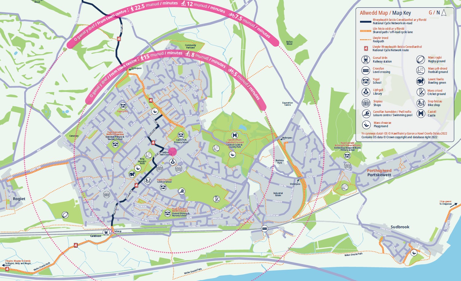
You can see from our Caldicot Active Travel Locality Map (see bottom of page), the distances involved are often short enough to be walked, wheeled or cycled. The fact that they are currently often done by car makes alternatives to driving less attractive to others too – this is an issue that could grow as more people move to the area. Caldicot, at the eastern end of the Severnside network, will benefit from improved transport options and mitigate the potential impact of population growth. We are building accessible routes and links in Caldicot to ensure active travel can be a safe, direct and comfortable way to get to where you need to go.

Education Scheme Phases 1 & 2
As part of developing the wider Active Travel network for Caldicot and the Severnside area, Monmouthshire County Council (MCC) is proposing redesign of the layout and traffic management for Woodstock Way in Caldicot, including the junction with Mill Lane. Through the proposed redesign, we aim to improve the safety and quality of the environment for those living and traveling in the local area.
Scheme specific, ring-fenced funding has been granted by Welsh Government from the Active Travel Fund for the construction of the proposed Woodstock Way redesign as early as possible this year, pending local approval.
The Woodstock Way scheme is part of the Severnside Spinal Route. Building on the Woodstock Way scheme, designs are in development to later make these additional improvements to Mill Lane:
- Continue the shared use active travel paths from north west and south east Woodstock Way down Mill Lane to the entrance to the Leisure Centre car park, increasing capacity for active travel and creating a more direct Park & Stride route to Caldicot Comprehensive School from the Leisure Centre car park.
- Install Sustainable Urban Drainage (SUDs) planting and drainage as part of the new layout on Mill Lane, for improved rain-water management and environmental benefits.
What is the change we expect to see?
- Safer, more pleasant environment
- Calmer traffic movements
- Biodiversity and air quality improvements
- Increase in local use of active travel
Caldicot Links Scheme
The Caldicot Links proposal is a phased, multi-element scheme. It aims to create an integrated network of routes that will have dedicated shared use facilities, connecting residents of Caldicot and Severnside to places of education and work, as well as shops and services. Its development supports improved equity of access, green infrastructure, well-being activities, destination management and local economic development actions.
This proposal would provide routes and route improvements between existing and planned residential areas and the town centre, focused on the northeast and east of Caldicot, Caldicot Castle and Country Park and the Greenway (formerly the Dinham railway MoD branch line) – areas included in the Replacement Local Development Plan (RLDP). This scheme aims to create the east Caldicot connection to Church Road, which saw footway, crossing and planting/drainage improvements to calm traffic and create an environment that is more conducive to active travel, constructed in 2022. Caldicot Links scheme phases:
Phase 1: Running along the route of the old ex-Ministry of Defence Dinham railway line, from just south of the Cornfield at Portskewett, to level with Caldicot Castle Country Park.
Phases 2 & 3: From level with the country park northwards to Crick, crossing the northeast Caldicot RLDP sites.
Phase 4 – Multi User Route: Running through Caldicot Castle Country Park connecting up with the Caldicot Links and the B4245 at its eastern end and linking into Church Road (and on to Caldicot Town Centre) at its western end.
More details on and updates for the Caldicot Active Travel – Links and Multi-User Route can be found Here Caldicot Active Travel Links and Multi-User Route – Q&A – Monlife
Caldicot Active Travel Locality Map
This post is also available in: