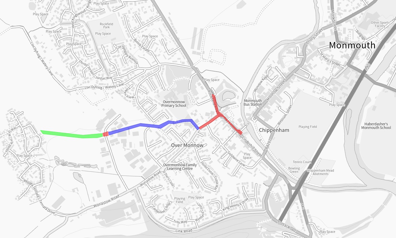
Williams Field Lane to Monnow Bridge Active Travel Route
A complete and accessible active travel route from Kingswood Gate housing estate, Monmouth, to Monmouth town centre via Wonastow Road Industrial Estate, Overmonnow Primary School and Old Monnow Bridge, with onward connections to Bridges Community Centre, Monnow Vale Community Hospital, Rockfield Road car park (MCC) and Monmouth skatepark.
The scheme was divided into phases:
- Blue: Williams Field Lane Phase 1
- Red: Wonastow Road to Monnow Bridge including Rockfield Road and Drybridge Street
- Green: Kingswood Gate path
Overall scheme objectives
- Provide a coherent, direct, comfortable, and attractive walking and cycling network from Overmonnow to surrounding communities, services, and facilities across Monmouth;
- Increase levels of sustainable access to employment, health, education, and services;
- Positively impact actual and perceived pedestrian, cyclist, and wheelchair user’s safety along and across the study area;
- Support modal shift in Monmouth towards more sustainable forms of transport;
- Reduce the negative impacts of transport on the natural and built environment.
Why were changes proposed?
The need for an improved route to Overmonnow Primary School was first recognised during Monmouthshire County Council’s Active Travel Integrated Network Map (INM) submission to the Welsh Government in 2018. Wonastow Road is an arterial route into the town and industrial area for vehicle traffic, but providing active travel routes in the area was challenging due to the legacy road layout, lack of footway and width in some sections, and a ditch/culvert that runs along the side of the road. A public right of way running between Kings Fee, Overmonnow, and St Thomas Road, Drybridge, offered a route away from sometime heavy vehicle traffic, but was a dirt path that was dark and inaccessible at times.
The housing development at Kingswood Gate has been one of the key drivers for changes being proposed, responding to local population growth by supporting modal shift and reducing pressure on local highway network. Walking, wheeling and cycling provision have a significant role to play in mitigating vehicle congestion, pollution, and health and wellbeing issues related to car-dependent lifestyles.
How was the scheme funded?
Funding for the various elements of this scheme has been granted from the Welsh Government Active Travel Fund, Safe Routes in the Communities (SRiC) fund as well as Section 106 monies from local developments.
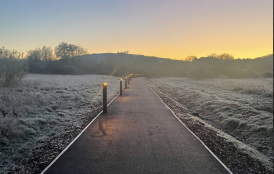
Kingswood Gate path
Constructed 2025
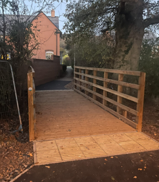
The Kingswood Gate housing estate lies to the West of Overmonnow Primary School and was built circa 2016 and contains over 300 houses. The estate is connected by road to Monmouth by Wonastow Road. This road has poor pavement infrastructure with no scope to improve sections, high levels of HGV movement with the local industrial estate and a lack of active travel infrastructure. There is little potential to improve this corridor, due to the proximity of roadside culvert and neighbouring properties. The pedestrian route provided with the development of the estate was not sufficiently accessible or direct, and the Section 106 funding from the estate set aside for development of the preferred ‘desire line’ route across the Kingswood Gate meadow proved insufficient to complete the path. MCC therefore developed the path using successive rounds of funding from the Welsh Government’s Active Travel Fund (in addition to the Section 106) and, in 2025, £338,000 construction funding was secured by MCC from Welsh Government Safe Routes in Communities (SRiC) Fund.
This phase of the scheme has taken longer to complete than originally planned. Land ownership, changing the alignment of the Public Right of Way, sensitive ecology, flooding and funding cycles have all been factors in increasing the time the process took. The path was opened for use in November 2025.
The scheme includes:
- A 3 metre-wide walking, wheeling and cycling path
- A culverted crossing over the ditch from the meadow into Kingswood Gate estate (West end of the meadow)
- Sustainable Urban Drainage (SUDs) features for ground water management along the length of the path
- Biodiversity-friendly low-level lighting
- Connection to the already constructed Wonastow Industrial estate crossing and the Williamsfield Lane path.
Walking and cycling data will be collected over the next couple of years to help build a picture and show trends of usage of the route. The Williams Field Lane section of the route saw increased use after its installation and continues to show good usage and obvious trends that people are using the route to go to and from school or a place of work. With the addition of the new Kingswood Gate section to this route it will allow even more people to choose to walk or cycle into Monmouth. The completed route connects directly to the crossing in Wonastow Industrial Estate, on to Williamsfield Lane and finally joins the Wonastow Road/Drybridge Street active travel paths, creating a continuous, direct and comfortable route for walking, wheeling and cycling between Kingswood Gate and the centre of Monmouth.


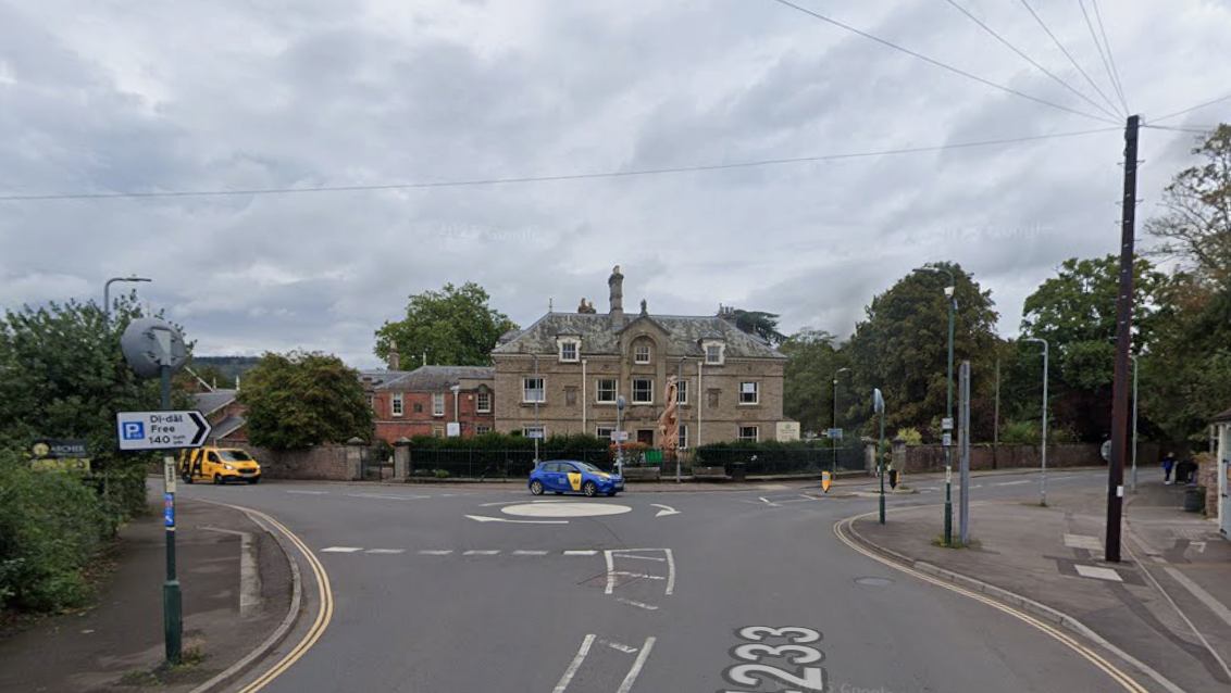
Wonastow Road to Monnow Bridge including Rockfield Road and Drybridge Street
Constructed in 2024
This phase of the scheme focussed on Wonastow Road, Drybridge Street and Rockfield Road and creating a connection between the Phase 1 Williams Field Lane and the Monnow Bridge. It provides improved access to Bridges Community Centre, Monnow Vale Hospital and the facilities and services within the town centre and beyond such as the leisure centre and Comprehensive School. It also provides a connection from the MCC free car park and Rockfield Road skatepark to the town centre.
Historically the roads in this area have a lot of traffic including large lorries accessing the Wonastow Industrial Estate. The road layout which included a painted mini roundabout allowed vehicles to move at speed even after the 20mph restriction was brought in. Together these issues alongside narrow pavements and poor provision for crossing the road made the area feel unsafe and uninviting for those walking and wheeling.
The scheme included:
- Widening the existing footway on the northern side of Wonastow Road to accommodate a shared-use footway/cycleway.
- Replacing the existing Wonastow Road/Drybridge Street/Rockfield Road mini-roundabout with a priority junction (T-junction).
- Providing a parallel crossing (like a zebra crossing but with a lane for cycling) on the Rockfield Road junction arm
- Providing an informal crossing (dropped kerb and tactiles) on the side road arm of the junction (Wonastow Road).
- Widening the existing footway on Rockfield Road from the new priority junction to Monmouth skatepark.
- Widening of a short section of the existing footway along Drybridge Street near the Monnow Bridge roundabout
- Removing sections of on-street parking along Wonastow Road to deliver the route in line with the Active Travel Act Guidance.
- Providing a parallel crossing across Wonastow Road Industrial Estate Road
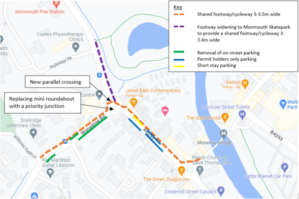


Wonastow Industrial Estate parallel crossing
Also as part of this phase of works, a parallel crossing (like a zebra crossing, but with a lane for cycling) was installed across the Wonastow Industrial Estate road, as this road carries large vehicles. This crossing is key in linking the Kingswood Gate path to the Williams Field Path and give those who walk, wheel and cycle a place to cross.


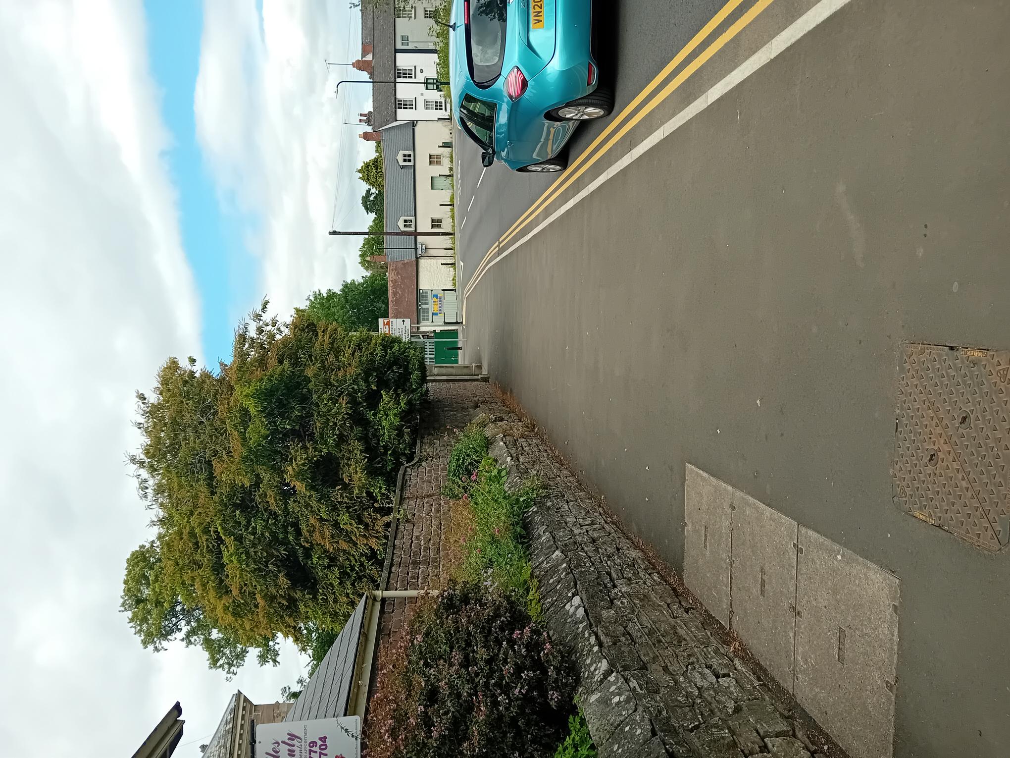
Williams Field Lane Phase 1
Constructed in 2022
The first phase of the scheme was the Williams Field Lane path. The path links multiple housing estates allows for direct, safe access to Overmonnow Primary school, the town centre and other facilities. Constructed in 2022, the scheme provided a 3m wide walking, wheeling and cycling route from the Wonastow Industrial Estate through to where Williams Field Lane connects with Wonastow Road. The route replaced a well-used but muddy track and primarily allowed for much safer access to Overmonnow Primary School whilst benefitting wider network connections to the town centre. The path features low-level lighting, designed to minimise impact on bats and other local wildlife. As a joint effort between MCC departments, a play park in Kings Fee was also constructed as part of this route phase. The play park, built either side of the path, allows for “play along the way” as well as an outdoor education space for Overmonnow Primary School. This section of the route was recognised in May 2025 as a benchmark for other Active Travel and “play along the way” schemes across Wales – https://www.monmouthshire.gov.uk/2025/05/monmouthshire-county-council-will-use-funding-to-improve-play-areas/
Data on route usage is gathered to monitor impact and usage trends. In the 3 years the route has been in place the data has showed an increase of traffic at peak times, giving evidence that the route is being used for ‘purposeful journeys’ such as getting to school or a place of work.
There is a short, narrow section running between two large industrial premises just off Wonastow Industrial Estate Road. Whilst the path still allows access, it is narrow and anyone wheeling or cycling along that section should exercise caution and look out for other users. Currently plans to widen this section are on hold due to the prioritisation of other schemes.


Data and Impact
This route has been monitored for walking, wheeling and cycling usage throughout its development. The data shows a trend of increased use at weekday school-times, which suggests the route is useful for purposeful journeys, such as trips to school and work, in addition to leisure journeys. Through anonymised data collection, path usage is monitored to measure the impact of route improvements.

For more information on MCC’s work on active travel in Monmouth, please visit Monmouth – Monlife
This post is also available in: