Castle Meadows FAQ
As part of the Welsh Government Active Travel funding achieved in 2023/24, phase 1 construction works on the Llanfoist to Abergavenny Active Travel Bridge are to be commenced in September 2023.
What work is being done?
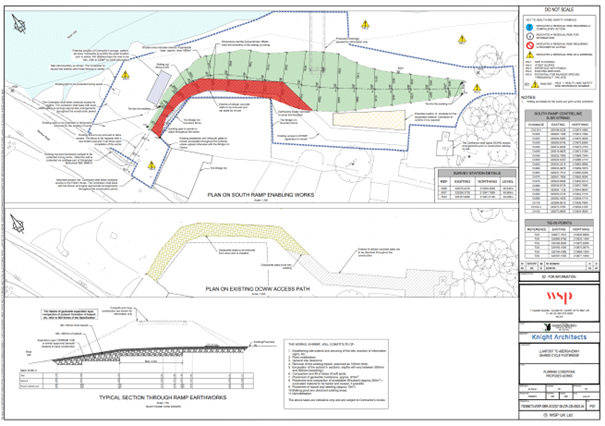
The only works that are programmed this year are associated with the active travel crossing at Llanfoist Bridge. Specifically, it is proposed to implement part of the southern embankment ramp works associated with the new bridge (see attached plan red highlighted area to immediate north of Bridge Inn pub grounds), which will satisfy the requirements of the planning permission, which requires works to be commenced on site by 4th October 2023. The construction will comprise the formation of at-grade base foundations for the southern bridge ramp.
When will it start and end?
The initial southern embankment ramp works will be undertaken from mid-September (estimated W/C 18th September 2023) and will last approximately 4 weeks in total.
When will the bridge be finished?
At present MCC are procuring a contractor to undertake the main Llanfoist to Abergavenny Active Travel Bridge works. It is proposed that the contractor would undertake most of the construction (paths, ramps, bridge itself) mid next year, with this currently scheduled to be completed by December 2024.
What about the biodiversity of the site?
We appreciate that the River Usk and adjoining Meadows are rich in wildlife and biodiversity, including otters. We are currently working closely with NRW and local stakeholders to ensure that the proposals do not impact on the otters and/or any other wildlife through all phases of construction.
Through the planning process NRW has been consulted on the proposals to improve existing paths through Castle Meadows, where an open dialog ensures any concerns are addressed. MCC consultants, WSP, have undertaken extensive surveys and have provided evidence to MCC to support the scheme proposals and overall application process.
What is happening with the Castle Meadows paths?
The Castle Meadows paths do not yet have planning permission, these will be considered by a future MCC Planning Committee and the outcome of this will determine the next steps. If successful, funding will be sought to construct the paths for financial year 2024/25. More information on the Castle Meadows paths and the wider Llanfoist to Abergavenny scheme can be found below.
Why are we doing the scheme?
The Abergavenny to Llanfoist Active Travel scheme is aiming to make a safer route for walking, cycling, and wheeling between the settlements. This incorporates a new bridge across the Usk, which gained planning permission in 2018, and links either side. The pathways through Castle Meadows are to be improved to Active travel standards to improve accessibility for all.
The Active Travel (Wales) act aims to reduce the amount of car journeys by improving the active travel routes between trip attractors. This in turn aims to reduce pollution, improve health and equality.
What are the overall plans?
The bridge plans:
The bridge gained planning in 2018, which can be seen here: Search for 2018/00408 https://planningonline.monmouthshire.gov.uk/online-applications/
Construction is due to commence late Summer/early Autumn 2023, with the bulk of construction work in 2024. The timings of works are affected by river levels and ecological restrictions.
Meadows plans can be seen below:
What are we doing in financial year 2023/24 on this scheme?
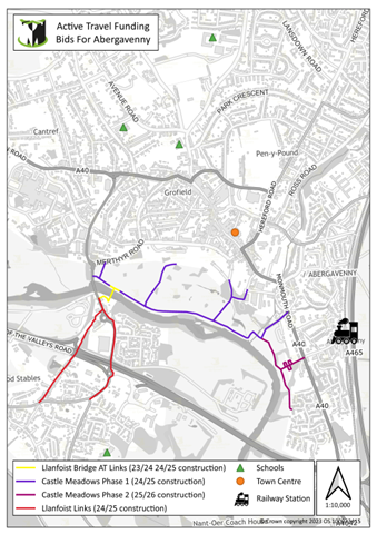
This application concentrates on the Active Travel links needed between the areas of Llanfoist and the main town of Abergavenny. It is based on a new Active Travel bridge and associated links that will deliver a number of Active Travel benefits. The overall outcome of the scheme seeks to deliver
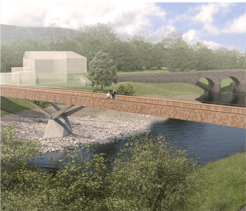
- A new pedestrian/cycle bridge across the River Usk about 50 metres east of the existing Abergavenny Stone bridge (a scheduled monument and also Grade II* listed).
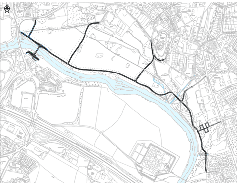
- Further connections in the form of an off-road Active Travel route through Castle Meadows into the town centre and on to the train station.
- Improved links to Llanfoist from the new bridge.
The new bridge will become the main river crossing between Llanfoist and Abergavenny for Non-Motorised Users (NMU’s). This will significantly reduce the risks associated with the existing narrow footway over the existing Abergavenny Bridge and encourage greater modal shift as a result. It is also important to ensure effective connections from the bridge (new and existing) into the town centre, to housing settlements in Llanfoist and other key destinations, so there is a seamless route. Welsh Government has in the past funded previous studies on the Llanfoist Bridge. The bid seeks funding to complete critical stages in the development of the Active Travel network between the Llanfoist settlement and the centre of Abergavenny town.
Active Travel Bridge
The scheme is listed in the LTP programme as 4th highest non-Metro priority. The scheme is Monmouthshire County Council (MCC) highest Active Travel Network Map (ATNM) priority for Abergavenny based on our recent Engagement phase and previous data. The scheme seeks to deliver a new pedestrian/cycle bridge across the River Usk about 50 metres east of the existing Stone bridge which is a Scheduled Monument and Grade II* listed. The new bridge has been sympathetically designed by a renowned bridge Architect and it is proposed that it will become the main river crossing between Llanfoist and Abergavenny for non-motorised users. This will significantly reduce the health and safety risks associated with the existing narrow footway over the existing Bridge. Tasks to include: address pre-commencement planning conditions, procure contractor/s, purchase materials for bridge, implement bridge and associate links and Property Floor Resilience (PFR) measures.
Castle Meadows
The scheme seeks to provide improved Active Travel compliant pedestrian and cycle links across Castle Meadows and Ysbytty Fields linking Llanfoist (via Llanfoist foot and cycle bridge) to Abergavenny town centre and Abergavenny rail station. Tasks to include:
- Castle Meadows – achieve planning permission, address any pre-commencement conditions, achieve FRAP for River Gavenny bridge, procure a contractor.
- Ysbytty Fields (including A40/Station Road crossing) – subject to successful land negotiations, undertake further surveys, firm up design, submit planning, achieve planning permission, address any pre-commencement conditions, procure a contractor.
Llanfoist Links
The scheme seeks to provide improved Active Travel compliant pedestrian and cycle links between Llanfoist and the new Llanfoist foot and cycle bridge – where pedestrians and cyclists can then continue their journey onwards via Castle Meadows and Ysbytty Fields to Abergavenny Town Centre and Abergavenny Rail Station. Tasks to include: completion of WelTAG Stage 3 Study (including associated surveys, and design), prepare tender pack, enquire and submit planning (if required) and any pre-commencement planning conditions, procure contractor/s, and begin construction.
What is the current planning application for?
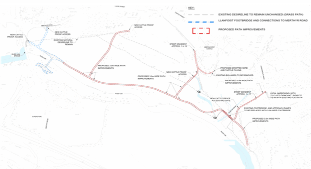
The planning application DM/2022/01831 is for the improved paths through Castle Meadows to Active Travel standards, including replacing the River Gavenny bridge. This application will be considered by the Council’s Planning Committee in the near future. This planning application does not include the new River Usk bridge or the paths to the northwest of the bridge linking to Merthyr Road which already have planning permission or the access points to Castle Meadows, which are covered by permitted development. It also does not include pathways on the Llanfoist side of the River Usk, these are currently being developed through a WelTAG 3 study.
Which surface material has been chosen?
During the design process, the engineering team identified many potential surfacing options which would be acceptable to different stakeholders. A preliminary choice of asphalt was made as this was seen to have the best wear characteristics for the yearly flooding events. Following consultation, the proposed surfacing material was changed to a more acceptable solution for the local populace.
The proposed surfacing material is now Resin Bound Permeable – Buff coloured.
Path alignment
The proposed alignment largely follows the existing semi-bound and cellular concrete paths, reducing the impact on the natural environment. Through the consultations we learnt that the preference was to limit the changes to the current alignment and keep the natural desire lines unchanged. By following the official and established paths, the scheme is considered more as an improvement/refurbishment of the existing, rather than new-build, which was preferential from the environmental and stakeholder perspective – not to industrialise the meadow.
Lighting
Lighting in the scheme has been removed following public consultation.
Funding for the scheme
The scheme has been funded by the Welsh Government through the Active Travel Fund, administered by Transport for Wales. This money is ringfenced for improvements to active travel routes through an annual application process on submitted schemes. All installed infrastructure must meet Active Travel guidance as set out here: https://www.gov.wales/sites/default/files/publications/2022-01/active-travel-act-guidance.pdf
Failure to meet criteria will result in the scheme not being funded.
Will dogs be required to be on leads in the Meadows because of this scheme?
No.
It is to be noted dogs must always be under the owner’s control in public, and MCC would always advise that dogs should be under close control (on a lead or at heel) around children, cyclists, cattle and when entering and leaving the meadows.
Cattle grid FAQ
Why were cattle grids chosen?
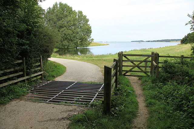
The challenges at Castle Meadows are complex, with grazing cattle for approximately 7 months a year, accessibility requirements from Active Travel guidance and current usage. After many discussions with various groups and those with experience of such challenges, it was agreed to copy a long existing design formula of a cattle grid with pedestrian gate alongside. This is used extensively on the National Cycle Network, including in Monmouthshire on the NCN 46 at Clydach Gorge without reports of any issues. Further examples can be seen at the bottom of this document.
It was agreed at a project meeting between stakeholders in July 2022 to implement a trial entrance point on the Meadows to test the grid and gate design before being implemented across all access points on Castle Meadows.
Design of the Cattle Grid
The Cattle Grid installed in Castle Meadows was designed and built to British Standard BS4008:2006. It was manufactured by a company who have over 20 years’ experience making grids without any known incidents and installed by reputable local contractors in accordance with CDM regulations.
Why were grids installed without planning permission?
The access point was upgraded through permitted development. This allows the council to improve the access point as seen fit.
Consultation
Public consultation occurred on the scheme in Spring 2022, with support for the scheme as a whole. There were comments of concern around the choice of cattle grids, which is why a trial was proposed instead of full implementation, as well as surfacing material and lighting which were addressed following public feedback. Wider consultation with other stakeholders, such as Guide Dogs and disability groups was conducted to ensure a wide variety of voices were heard.
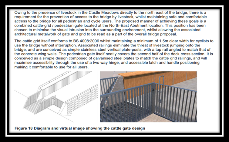
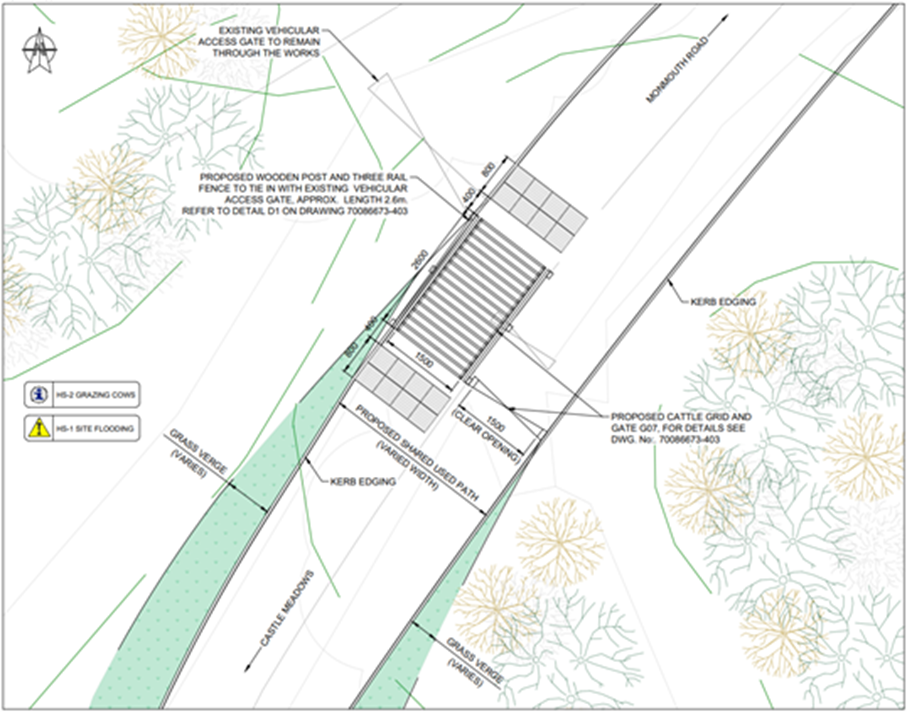
Entry point from new Active Travel Bridge
The River Usk bridge has planning permission with a cattle grid and gate arrangement on the Meadows side to stop cattle from crossing the bridge. This can be seen below in an extract from the previously approved planning documentation:
Next Steps
These plans have been shared with the funding body and received an agreement in principle to proceed, subject to detailed design.
Abergavenny Town Council are hosting a stakeholder meeting in mid-July 2023 to discuss the scheme proposals following on from the progress made since the last session in July 2022. The project team remain committed to working with all stakeholders for delivery of the project.
What entry points are proposed now

Entry points of Castle Meadows
- 1.New Active Travel Bridge
- 2.Merthyr Rd (adj. to existing Llanfoist Bridge)
- 3.Merthyr Rd (adj. to service vehicle entrance)
- 4.Byefield Lane Car park
- 5.Mill St (Castle & Trial location)
- 6.Mill Lane
- 7.Ramp to Station Rd
- 8.Glyndwr Gardens
G. Gavenny Bridge
Entry points 1, 3, 4, 6
Due to the location of these points, with a road or car park immediately adjacent to the entry point, close control of young children and animals is required and as such would be under supervision. The design of these access points is envisaged to be similar to those which were trialled, but with a different gate and narrower Cattle Grid.
The gate will be a slow self-closing, non-latched, push to open into the Meadows. This will have a 1.5m opening and the side of the gate would allow easy reach for those with mobility restrictions to open the gate. The grid width will be 1.5m wide to meet Active Travel standards and length currently envisaged to be 2.6m to stop cows jumping over the grid (British standard). The details of the grid (spacing and bar size) are to be confirmed following discussions with cattle grid specialists, which have been ongoing since scheme inception. It is hoped the design and alignment of the grids can be such that the natural flow of foot movement will be more directed to a gate and dog opening, the wheeled access route will be a slight deviation from visual desire.
The above will be in operation during grazing times on the Meadows (maximum late June – late January). At non- grazing times, the gates will be locked in an “open” position, providing a continuous 1.5m width entry point for all users. The cattle grids will then be either closed off with gates or covered with a continuous surface during this time.
Images above shows 1.5m grid and gate set up (Entry point 6).
Entry point 2
This access point will become secondary once the new Active Travel bridge is constructed and will be upgraded to a push gate only.
Entry point 5
The use of this entry point has been seen to be different to that envisaged by the project team, with dogs let loose well in advance of entering the Meadows. The distance from a road means dog owners feel safe to release their dogs before entering the Meadows, resulting in free running dogs on both sides of the access point.
This entry point will be a push to enter, self-closing gate, which will be 1.5m wide. The access to the gate on the Meadows side will be sufficient to wheel alongside the gate to allow for easier opening reach for those with mobility restrictions. This will be latched open when cattle are not grazing on the meadows. This set up is currently being tested on the current Gavenny bridge and has had positive feedback so far with local disability access groups.
Entry point 7 & 8
The design for these access points is still in consideration due to the infancy of the scheme in this phase.
Gavenny Bridge
The previously proposed cattle controls on the Gavenny Bridge (G on map above) are to be removed to allow free movement of all Meadow users (including cattle) across the bridge, this removes 2 gate/grid constrictions on the scheme, the cattle already cross the adjacent brook and graze both sides.
Contact us
If you would like to contact the project team, please email ActiveTravel@monmouthshire.gov.uk
Examples of similar access points
https://www.sustrans.org.uk/our-blog/projects/2020/england/route-upgrade-kennington-meadows-oxford/
CycleStreets » Photomap » Search » cattle grid
Burton Marshes – Superb Cycle Crossing of River Dee (cyclingnorthwales.co.uk)
https://www.geograph.org.uk/photo/3676050 National Cycle Route 52
Route upgrade: Kennington Meadows, Oxford – Sustrans.org.uk
Useful Links
Active Travel Design guidance
https://www.gov.wales/sites/default/files/publications/2022-01/active-travel-act-guidance.pdf
Llwybr Newydd – The Wales Transport Strategy 2021
Monmouthshire Community and Corporate Plan
Community and Corporate Plan – Version 3.0_Council.pdf (monmouthshire.gov.uk)
Sustrans design guidance on Greenway access for routes (9.4.5 Livestock control)
Monmouthshire Open Access Guidelines
www.monmouthshire.gov.uk/app/uploads/2013/09/Monmouthshire-Access-Design-Guide-Final-19-03-12.pdf
This post is also available in: Welsh