Joel Hamer – Page 2 – Monlife

Community-curated exhibition ‘What Makes Monmouth, Monmouth’ tours locally

‘What Makes Monmouth, Monmouth’ exhibition is now at Monmouth Leisure Centre. As part of the exhibitions tour around Monmouth, residents and visitors can now view the collection at the Leisure Centre over the school summer holidays. 

The exhibition will tour different community venues in Monmouth until March 2025. 

A partner exhibition can also be seen at Monmouth Shire Hall until March 31, 2025.

The exhibition is part of Museum Services ‘Dynamic Collections: Opening the Box’ project, funded by the National Lottery Heritage Fund. Residents from different local communities were invited to ‘open the box’ to the Shire Hall museum’s collection. They chose objects they thought told a story of Monmouth for them and gave their personal stories which are displayed in the ‘What makes Monmouth, Monmouth’ exhibition. The exhibition includes many objects, photographs and paintings that have never been displayed before, connecting us to our rich local history and culture.

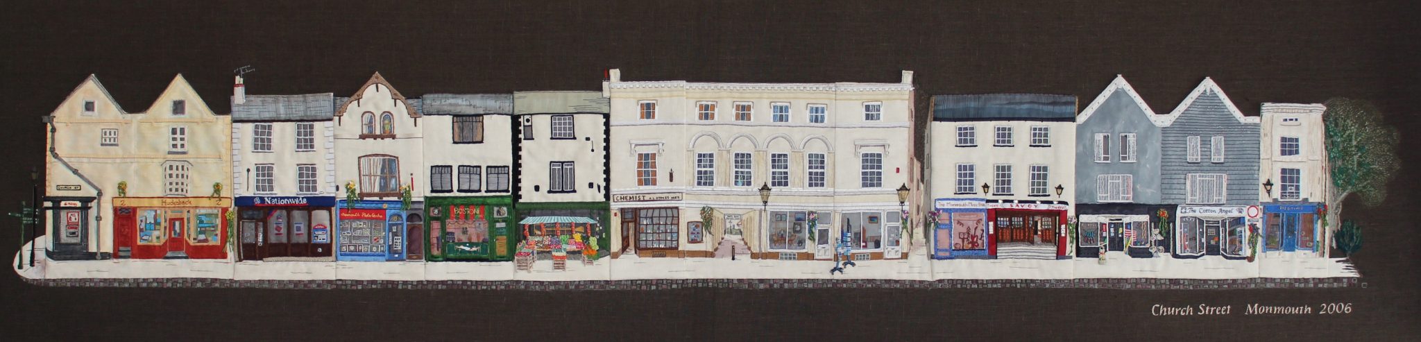
Church Street embroidery, 2006 – will form part of the display

Alongside the exhibitions at the Leisure Centre and the Shire Hall this summer, MonLife Museum officers will also hold free family craft activities. The activities are available for all ages, so make this a summer of discovery and pop along to take part. Find out more here: www.monlife.co.uk/events/

Monmouthshire County Council’s Cabinet Member for Equalities and Engagement, Cllr Angela Sandles, said: “Thank you to the National Lottery Heritage Fund, donors to the museums, and our volunteers for making this project and exhibition possible. Showcasing the vast history of our towns is vitally important. Our team’s work, along with volunteers, is a true testament to their commitment to keeping local history alive. I’d urge everyone to come along to see ‘What Makes Monmouth, Monmouth’.”

The Shire Hall exhibition is open daily from 11 am to 4pm except for Wednesdays and Sundays (open Sundays during school summer holidays). The touring exhibition can be seen any time during open hours at Monmouth Library and Hwb, and after at Monmouth Leisure centre. Admission is free.

Find out more about exhibitions in Monmouth here: www.monlifecollections.co.uk/projects/dynamic-collections/

If any venues would be interested in hosting the touring exhibition, please contact carolinehaines@monmouthshire.gov.uk 


Abergavenny Active Travel Bridge scheme including Llanfoist Links & Castle Meadows 

We are focusing on active travel links between Llanfoist and Abergavenny, with our route designed around a new active travel bridge crossing the River Usk between Merthyr Road and Castle Meadows, and associated links for safer, more attractive and direct sustainable routes into Llanfoist and Abergavenny.  

Monmouthshire County Council has secured £10.4m from Welsh Government’s Active Travel Fund to develop the Abergavenny to Llanfoist Active Travel Scheme. Our construction partner for this scheme, Balfour Beatty, appointed under the SCAPE framework, will soon launch a scheme website – we will share the link here when it is available.

This scheme is a central priority for the development of Monmouthshire County Council’s Active Travel network, addressing the active travel severance point of the Merthyr Road bridge. This funding is bid for in a competitive national bidding process and once allocated is ring-fenced for this active travel project and cannot be spent on other projects, schemes or council services.   

  • Increase in active travel journeys in Abergavenny 
  • Improved connectivity and accessibility for active travel trips in and between Llanfoist and Abergavenny 
  • Improve actual and perceived levels of personal safety and security when walking and cycling 
  • Promotion of sustainable travel as attractive and safe in Abergavenny and Llanfoist. 
Video: Abergavenny Active Travel flythrough of scheme vision. Current construction is focused on delivering the active travel bridge.

Active travel bridge  

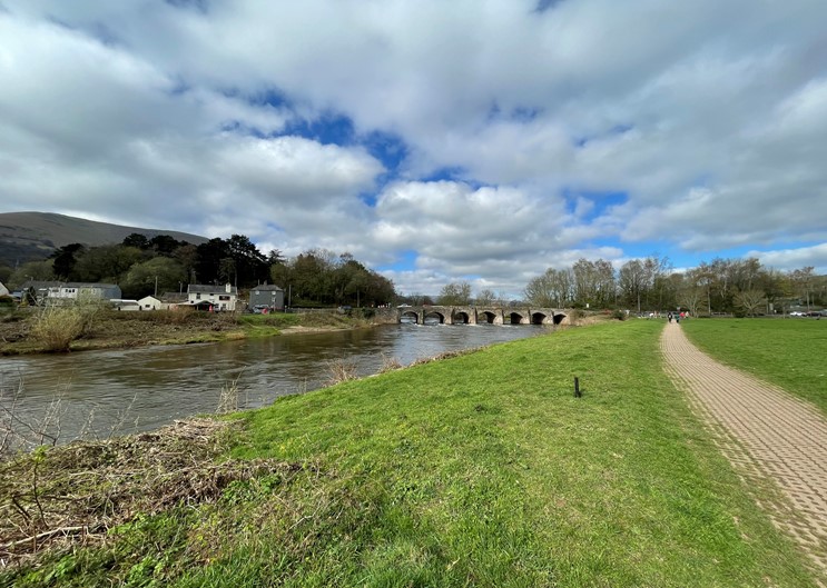
Provision of a new walking, wheeling and cycling bridge crossing on the Usk between Llanfoist and Abergavenny, downriver of the Usk Bridge (Merthyr Road). The bridge will become the main river crossing for active travel between Llanfoist and Abergavenny, as an alternative to using the narrow footway over the existing road bridge and encourage modal shift as a result.

Merthyr Road/Usk Bridge has long been identified as a severance point for active travel, and MCC has prioritised the development of this route.  The existing bridge over the River Usk provides a very narrow footway on one side and does not cater for cyclists. The road bridge is a listed structure that carries a heavy volume of road traffic. There is currently little scope physically, or with its listed status, to make it more welcoming or safe for active travel. The overall aim is to provide an alternative river crossing for active travel, and ensure effective connections from the bridges (new and existing) into the town centre, allowing healthy travel between homes and key destinations such as schools, Nevill Hall and the town centre. 

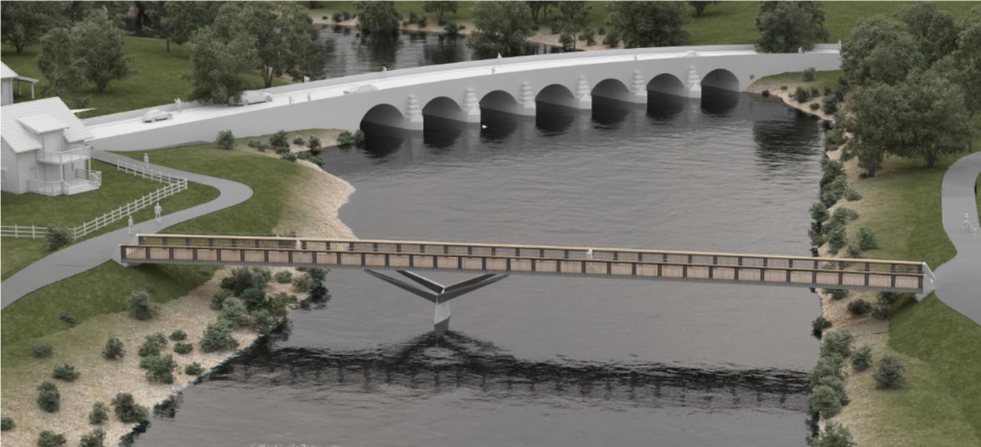
This scheme will construct a new 3m wide walking, wheeling and cycling bridge across the River Usk, linking Llanfoist to Castle Meadows, Abergavenny. The bridge will be made of a steel beam construction with wooden cladding to ensure that it fits in with the natural surrounding area. Ramps will be constructed to connect the bridge to the paths on Castle Meadows and footway on Merthyr Road, Llanfoist.  

Construction of the bridge is planned to commence in early 2026, with phased work continuing into 2027. Planning permission was granted for the active travel bridge in 2018 as DM/2018/00408, with permission granted in 2025 for non-material amendment to include steel beam construction – planning number DM/2025/00507. 

Balfour Beatty, scheme construction partners, will soon launch a scheme website – we will share the link here when it is available.

Image – Active travel bridge on pier downriver of the road bridge

Castle Meadows

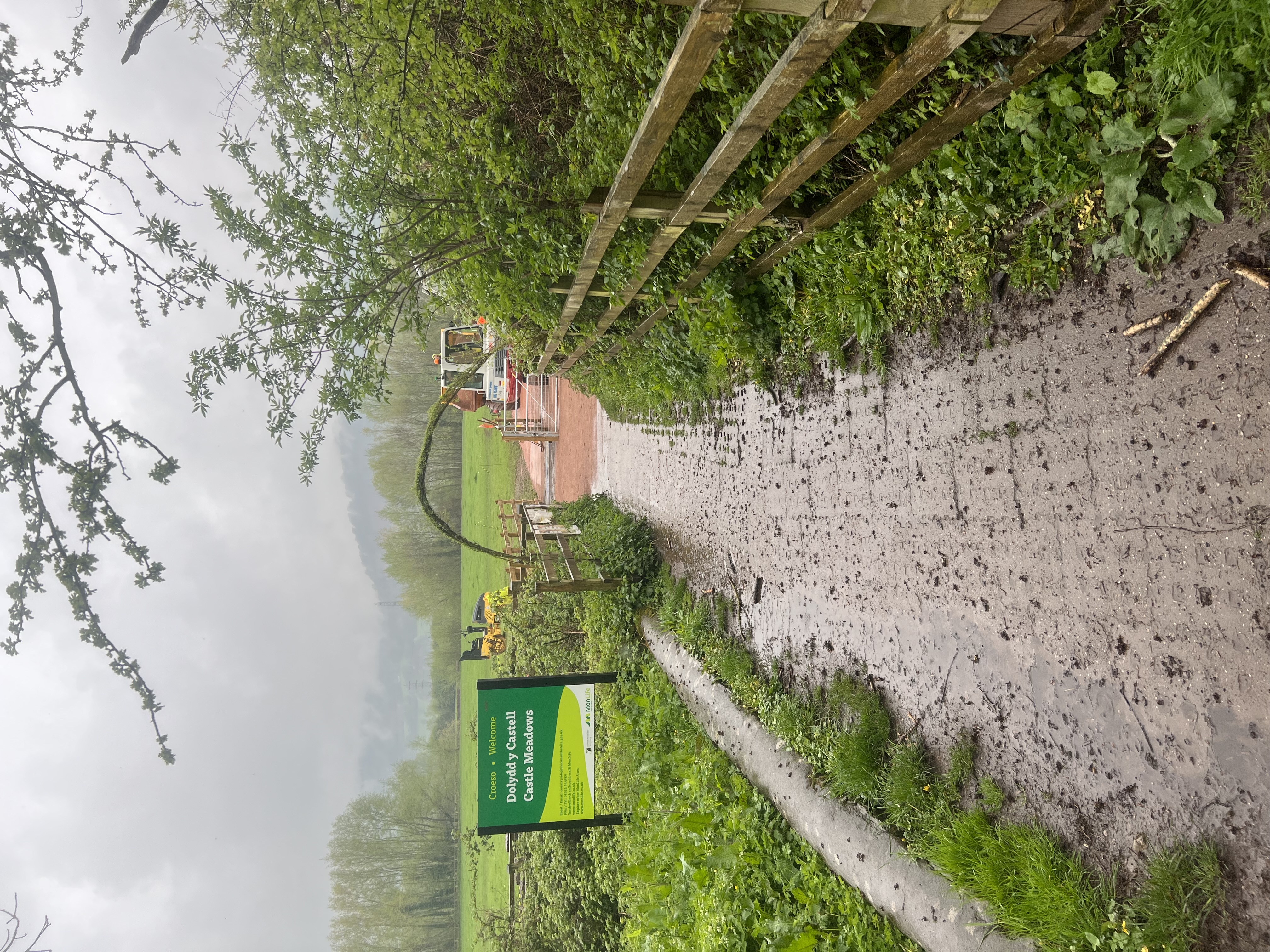
Castle Meadows and Ysbyty Fields are important leisure areas for the community and are crossed by Public Rights of Way (PRoW) and National Cycle Network routes 42 and 46. Improvements to the surfacing of routes on Castle Meadows can support pedestrians and cyclists travelling between Llanfoist and Abergavenny, in combination with the new active travel bridge.   

As the scheme progresses further work will identify possible upgrades to paths within the meadows with the current funding available. The full extent of paths with potential for upgrade on Castle Meadows gained planning permission in 2023, as planning application DM/2022/01831. 

The objectives of the scheme have been derived through identification of key issues (as summarised above), and also according to the objectives set by the MCC and national policy.  The objectives are as follows: 

  • Ensure connections from the town centre through Castle Meadows to Llanfoist are accessible, to allow people the option of alternatives to driving this route. 
  • Increase the number of pedestrians and cyclists using Castle Meadows for commuting and leisure purposes; 
  • Make a positive contribution to air quality by promoting active travel 
  • No significant adverse impacts on environmental sensitive receptors during construction and operation, protect and enhance the historic, built and natural environmental including landscape and settlement character of the area. 
  • Inaccessible and unattractive route across road bridge causes restricted access to Castle Meadows.
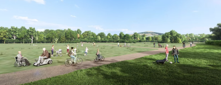
  • Grasscrete paths: The existing grasscrete paths are in a poor state of repair and don’t comply with active travel guidance for path surfaces. They are uncomfortable and difficult for wheelchair / mobility chair users to use.  
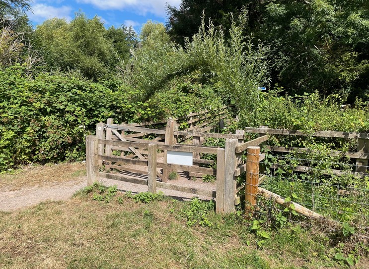
  • Restrictions at access points: A self-closing, latch-free gate has been trialled on the meadows for the last two years. The gate opens into the meadows, meaning cows cannot push the gate open and venture out. The existing wooden style kissing gates are restrictive to wheelchairs, mobility scooters, pushchairs, and cyclists gaining access to the meadows.  

The WelTAG  (Wales Transport Appraisal Guidance) study of this area looked at ways to improve the provision for active travel on Castle Meadows. Following this study, MCC sought planning permission to upgrade all of the main paths on Castle Meadows, pending funding availability and to allow flexible planning as the bridge plans were developed. MCC does not plan to upgrade all paths within the planning agreement, but is working to include some paths within the current scheme of works. 

Image: Artists impression of Castle Meadows paths. N.B. MCC does not plan to upgrade all paths within the planning agreement as part of the bridge construction works.

Llanfoist Links  

This phase looks at route improvements focused on the Llanfoist side of the River Usk and connections to the active travel bridge and Castle Meadows. Elements of this broad scheme will be included in the construction works, with other sections being brought forward as and when funding allows.  

  • Improve access to local services, employment, and cultural facilities by Active Travel modes by improving connectivity between Abergavenny and Llanfoist. 
  • Promote and facilitate healthier lifestyles by increasing the number of pedestrians and cyclists using Merthyr Road and The Cutting for commuting purposes. 
  • Make a positive contribution to air quality by promoting active travel in MCC and supporting the reduction of Carbon Dioxide around the Abergavenny / Llanfoist area. 
  • Introduce safe and accessible active travel links and remove conflicts between users around the ‘Waitrose’ Roundabout. 
  • Provide a coherent, direct, and future-proof cycle route which connects with the existing and planned active travel infrastructure. 
  • The existing road network in the area is extremely busy, making the environment unappealing for pedestrians, cyclists, and those with mobility impairments.  Analysis of 2011 Census data identified that 15% of drivers in the area travel less than 2km and 8% between 2km and 5km.  Some of these trips could be accommodated by Active Travel modes if adequate Non Motorised User infrastructure would be provided. 
  • There are currently no off-road cycle facilities: as such cyclists have to use the existing carriageway/s to travel. 
  • A lack of adequate crossing facilities at the ‘Waitrose’ roundabout. 
  • At sections of the scheme, footways are narrow and sub-standard, forcing pedestrians into close proximity to the carriageway and traffic. 
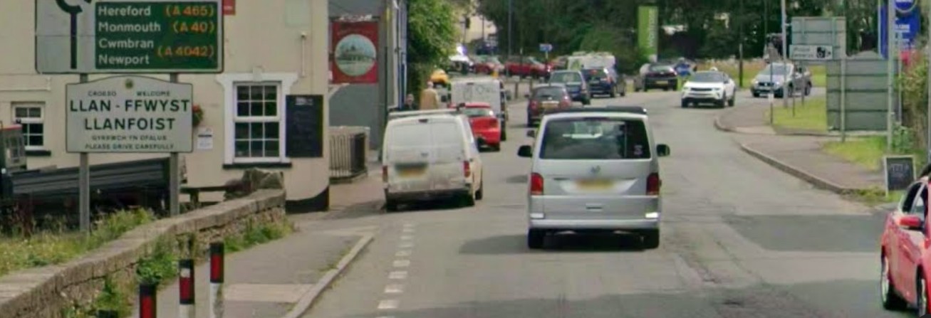
  • There are significant perceived road safety issues, particularly along Merthyr Road between the Bridge Inn pub and ‘Waitrose’ roundabout. 
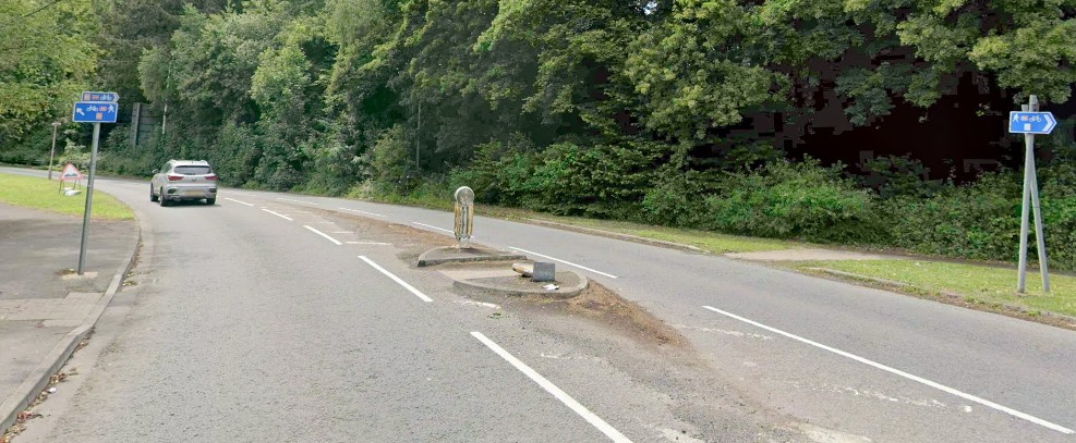
  • The Cutting is recognised as low traffic and, as such, has the potential to serve as a link from Merthyr Road to Llanfoist, but the current link route behind Waitrose Petrol Station is narrow and overgrown at points. 

The Wales Transport Appraisal Guidance (WelTAG) study of this area looked at ways to improve the provision for active travel links between Llanfoist and Abergavenny and proposed the interventions below. Some interventions included on this list will be rolled out as development and construction funding becomes available, with others to be re-investigated once the bridge is constructed. 

  • The widening of the existing footway along the eastern side of Merthyr Road between the Bridge Inn pub and ‘Waitrose’ Roundabout, to accommodate a 3.5m wide shared (pedestrian and cycle) route. To accommodate this proposal, on-street parking at this location will be removed. 
  • The provision of new crossing facilities across three arms of Merthyr Road. 
  • The widening of the existing footway along the eastern side of Merthyr Road between Waitrose Roundabout and the Heads of Valleys Slip Road / Merthyr Road Roundabout to the south to accommodate a 3.5m wide shared (pedestrian and cycle) route.  
  • The widening of the existing footway along the eastern side of Merthyr Road between the Heads of Valleys Slip Road / Merthyr Road Roundabout and Gypsy Lane, to accommodate a 3.5m wide shared (pedestrian and cycle) route.  
  • The provision of improved more direct crossing points across Coopers Way and the eastern and western arms of the Heads of Valleys Slip Road / Merthyr Road Roundabout. 
  • The widening of the existing footway along the back edge of the car park located to the immediate north of ‘Waitrose’ Roundabout, to accommodate a 3.5m wide shared (pedestrian and cycle) route.  
  • The widening of the existing footway along the back of Waitrose Petrol Station between ‘Waitrose Roundabout’ and The Cutting Heads of the Valleys Road underpass, to accommodate a 3.5m wide shared (pedestrian and cycle) route.  
  • The promotion as a ‘Quiet Way’ (through additional signage and road markings) of The Cutting (without impacting the existing access and parking arrangements) between The Cutting Heads of the Valleys Road underpass and Merthyr Road to the south. 
  • The improvement of the existing The Cutting and Merthyr Road priority junction arrangement. 

Proposals along Merthyr Road – Section 1

Proposals along Merthyr Road – Section 2 

Proposals along The Cutting – Section 1

Proposals along The Cutting – Section 2

For more information on MCC’s work on active travel in Abergavenny, please visit Abergavenny – Monlife


Caldicot Active Travel Links and Multi-User Route

The Caldicot Links active travel scheme is designed to create an integrated network of shared use routes, linking existing and planned residential areas around east Caldicot to local destinations and public transport. The aim is to enable residents to use active travel for local trips and to connect to the wider Severnside active travel and public transport networks, through the construction of high quality and accessible routes for walking, wheeling and cycling.

Caldicot Active Travel Links scheme

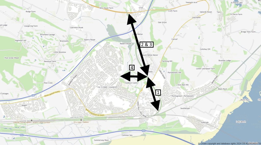
Caldicot Links scheme focuses on the north and east of Caldicot. The scheme is in three sections* (see plan below):

  • Phase 1: Running along the route of the old ex-Ministry of Defence Dinham railway line, from just south of the Cornfield at Portskewett, to level with Caldicot Castle Country Park.
  • Phases 2 & 3: From level with the country park northwards to Crick, crossing the northeast Caldicot RLDP sites.
  • Phase 4 – Multi User Route: Running through Caldicot Castle Country Park connecting up with the Caldicot Links and the B4245 at its eastern end and linking into Church Road (and on to Caldicot Town Centre) at its western end.

*Sections of the scheme are being brought forward as funding and other constraints permit, i.e. not necessarily in numerical order.

Current progress

Phase 1: Construction completed providing an approximately 1km long tarmac surfaced shared route open to the public.

You are welcome to use this section of the new Caldicot Links active travel route for walking, wheeling, and cycling. Please note that this route is not being promoted as accessible to all users at this time and represents the first stage in delivering a complete connection from Portskewett to Caldicot.

Please note the following:

  • Caldicot Castle Country Park: There is currently no formal hard-surfaced path connecting this tarmac path to the Country Park tarmac service road. Users wishing to continue into the Country Park will need to use informal grass paths, which have uneven surfaces, slopes, and gates.
  • Elderwood Parc: There is no onward connection from the top of the ramp into Elderwood Parc due to the housing development still being under construction.

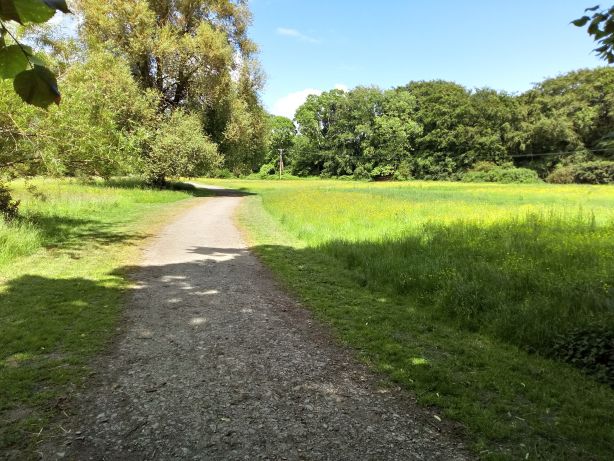
Picture: The new Caldicot Links Phase 1.

Phases 2 & 3: MCC appointed consultants have undertaken a study of the options available for developing the route north and east of the Country Park, considering the key opportunities and the constraints of this area. Further scheme progression is dependent on the future development of the RLDP sites adjacent to it and funding availability.

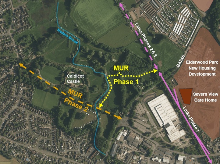
Phase 4 – Multi User Route (MUR): This phase has now been split into two sub phases (see plan below) to aid development.

MUR Phase 1 connecting up the northern end of the completed Links Phase 1 with the existing tarmac service road running through Caldicot Castle Country Park, via a new hard surfaced shared use path.

A public consultation on the scheme proposal took place throughout August 2025 which demonstrated good community engagement, interest and support for the MUR Phase 1. It also identified key elements that would improve the scheme for users, that have been incorporated into the design where possible.

A summary of the consultation results can be found here.

The full consultation report is available here.

The scheme is now in the construction stage, that is currently planned to run until September 2026.

For the safety of Caldicot Castle Country Park users it will be necessary to temporarily close some parts of the country park during the works (along the MUR Phase 1 route and the temporary works compound). More details will follow via this webpage and on-site signage.

Visualisations of the scheme design can be seen on a separate project webpage.

MUR Phase 2 running west-east through the country park from the western entrance off Church Road to the eastern entrance and connection with the B4245. Initial assessments have been undertaken but there is currently no funding available to progress the design.

Caldicot Multi-User Route phasing plan
Picture: Caldicot MUR phasing
Picture: Proposed MUR phase 1 route alignment along line of existing gravel track

Why focus on north and east Caldicot?

This scheme looks to improve sustainable access to services, shops, and sites of education and employment around Caldicot. Trip generation related to the planned residential development to the east and north of Caldicot, as well as the need to mitigate congestion related to local employment sites and the newly toll-free Severn bridges gives extra impetus to the scheme, as this is an opportunity to make active travel the preferred mode for local trips for old and new residents alike. It also has added value of providing an attractive route for recreational activities and providing improved access to local community green spaces, such as Caldicot Castle and Country Park and the Cornfield Project, as well as to the Wales Coast Path and the wider Gwent Levels Landscape of Outstanding Historic Interest.

The phased Caldicot Links scheme focuses on the east of Caldicot, including linking to housing developments off Church Road and Crick Road, to ensure that current and future residents have accessible, healthy and sustainable transport options, to minimise and manage the road traffic impact of a growing population and to direct residents and visitors into the town centre as a local destination.

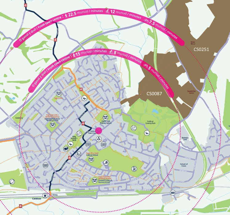
Below is a detail of our Active Travel Map for Caldicot, showing the time it would typically take to travel in the local area. The local development areas, shown in brown, will include parcels of green space (i.e. the indicated sites include areas that will not be built up):

What is active travel?

Active travel is a term used to describe walking, wheeling or cycling to a destination, which the Active Travel Act (Wales) 2013 calls “purposeful journeys”. It does not cover trips taken purely for leisure although it could significantly enhance leisure activities by helping to link up networks. Active travel can be used to get to school, work, services and shops, or as one of several modes on a longer journey – for example, walking to the station to catch a bus or train. Monmouthshire County Council (MCC)’s active travel strategy focuses on journeys of three miles or less, which means improving walking and cycling infrastructure within communities and between close-by settlements such as Caldicot, Portskewett and Crick, so that active travel can be the natural choice for local journeys. MCC also aims to improve active travel links to public transport, to support sustainable travel across the county.

How is the Caldicot Links scheme funded?

The Caldicot Active Travel Links and Multi-user routes project development and construction works to date have been funded by Welsh Government grants aimed at improvements to sustainable transport modes.

Contact us

If you would like to contact the project team, please email ActiveTravel@monmouthshire.gov.uk

For more information on MCC’s work on active travel in Caldicot, please visit Caldicot – MonLife


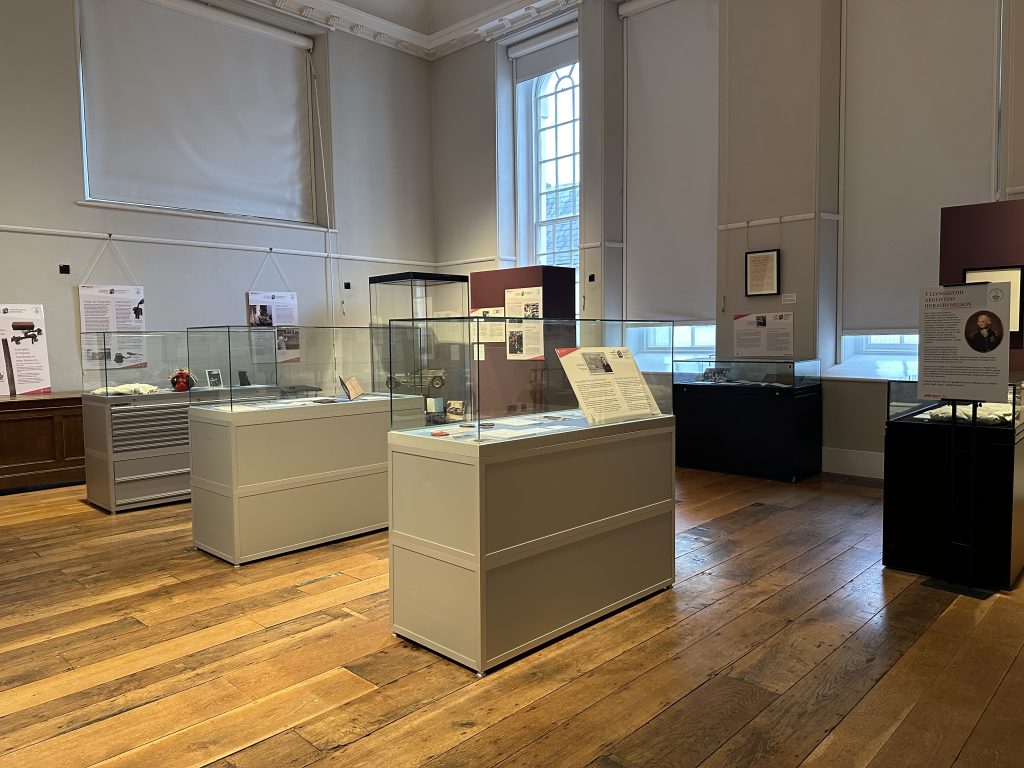
New Exhibition at Shire Hall Museum

Throughout January, a new exhibition has been displayed at the Shire Hall to celebrate its 300-year history. This exhibition is the first of many new displays showcased at the new Shire Hall Museum.

Alongside the exhibition, the Shire Hall team will engage with our local communities and speak to visitors to understand what topics and themes they want to see in the museum. All feedback will be used to create the Interpretation Plan that will shape the design and visitor experience of the museum.

In addition to the exhibition, visitors can view the recent collection reviews carried out across MonLife’s museums.

Funded through the National Lottery Heritage Fund, this work supports the move of the Nelson and local Monmouth collections into their new home at Shire Hall. The grant is a welcomed positive addition, especially with the increasing pressure felt on cultural services due to reducing budgets. The work will help shape a sustainable future for the museum. Visitors will have an opportunity to vote on the key objects and themes related to Lord Nelson, which will further shape the future exhibitions at the new museum.

All this work has been part of the Dynamic Collections – Opening the Box project that the museum has been carrying out throughout 2023. After reviewing the Nelson collection, the team identified a collection of national significance. Now is your opportunity to provide feedback on what matters to you within the collection.

Monmouthshire County Council’s Cabinet Member for Equalities and Engagement, Cllr Angela Sandles, said: “The new exhibition at the Shire Museum is an excellent opportunity for local communities and visitors to Monmouth to learn more about the history of such an iconic building in the heart of the town. We want to provide a space where everyone can learn about their local history and view displays they want to see. Please visit the exhibition and learn more about the fantastic work being undertaken in MonLife Museums.”

Find out more about what’s going on at the Shire Hall here: https://www.monlife.co.uk/heritage/the-shire-hall/ 


MonLife becomes ‘Centre of Excellence’ for the Leadership Skills Foundation.

The MonLife Sports Development team has been named a Centre of Excellence by the Leadership Skills Foundation for delivering the PlayMaker Award for Year 5 pupils across all primary schools in Monmouthshire.

The status recognises that MonLife Sports Development has excelled in implementing leadership and promoting the message of believe, lead and succeed through its high-quality provision. The Centre of Excellence status is awarded to the top 2% of the 2,500 centres.

Children playing. Children placing a ball on a sports cone

Having delivered the PlayMaker Award since 2017/18, the team have delivered the training to more than 5,500 pupils, with 100% of schools engaging in the programme.

The PlayMakers Award aims to support young people in developing their leadership skills and provide the knowledge and skills to plan and organise sports provision at their school. This allows young people to create activities they can deliver during break and lunchtimes safely. Through the PlayMaker Award, the pupils will gain critical communication, leadership, organisation and resilience skills.

The PlayMaker Award is the starting point for pupils on the Sports Development leadership pathway. Upon completing this award, there is potential for pupils to progress on to the Year 6 Bronze Ambassador scheme and later to the Secondary School Leadership Academies. The pathway spans from Year 5 onwards and provides the skills and knowledge necessary for students to pursue post-16 employment opportunities.

Monmouthshire County Council Cabinet Member for Equalities and Engagement, Cllr Angela Sandles, said: “This is such fantastic news for the team to be recognised for their dedication. The Sports Development team ensures that pupils lead an active lifestyle and gain key skills in communication, leadership and organisation. These skills will allow them to develop in school and when entering the working world.

For more information on Sport Development programmes, or to contact the team, please email sport@monmouthshire.gov.uk.


All welcome to help shape the future of visual arts in Monmouthshire

Ann Sumner and Beth McIntyre meeting with Emma Bevan-Henderson, Chair of the Abergavenny Art Festival meeting at the Makers Crafts Gallery in Abergavenny 
 

We have exciting updates associated with the VAMM (Visual Arts Mapping Monmouthshire) Project research. This  work was organised through the Creative Cardiff partnership with MonLife as part of the Creative Industries Cluster Hubs (CICH) project.

  1. Commission Opportunity

Creative Cardiff, who in partnership with Local Authorities in Monmouthshire, Newport and Rhondda Cynon Taf, is currently seeking to commission nine artists to produce a piece of work on the theme of local creativity, community and innovation. This opportunity is being delivered as part of the Creative Industries Cluster Hubs (CICH) project.  Please note that commissioned works can be multidisciplinary across a variety of creative mediums, including but not limited to: visual arts, sculpture, video, spoken/written word, textiles, performance, dance, installation etc.

Applicants must be living or working in Monmouthshire, Newport or Rhondda Cynon Taf. Creative Cardiff is looking to commission three artists from Monmouthshire with up to £1000 available for each artist.   The deadline  is 31 January 2024   and can be found on the Creative Cardiff website: https://creativecardiff.org.uk/creative-cardiff-artist-commission

  1. FREE Creative Cuppas hosted by The Borough Theatre in Abergavenny and delivered by Creative Cardiff

 Thursday 25 January at 10 am

Making workspaces accessible for neurodivergent creatives with producer, Tom Bevan. Tom is a freelance theatre and live events Producer from Cardiff. He has ADHD and Dyslexia and wants to create spaces where neurodivergent creatives can get together and build solidarity, support and collaborations. Since October 2023, he has been hosting an open space for neurodivergent creatives, producers and artists working in the cultural sector in South Wales to come together to work and connect.

Creative Cuppa: January (Monmouthshire) | Creative Cardiff

Thursday 22 February 2024 at 10.00 am  

Creating digital content with Amy Pay, a highly experienced freelance journalist, copywriter and creative consultant based in the Cardiff Capital Region. With a varied background in print media, broadcasting and digital journalism, she uses her skills to help people to get their stories across through words, strategy and creative ideas. She’s worked with clients big and small, including Lonely Planet, Visit Wales, The Telegraph, Evening Standard and The Guardian, with specialisms including UK travel, small businesses, specialty coffee and creative industries. Please see the link below to read further details and book your place:

https://creativecardiff.org.uk/creative-cuppa-february-monmouthshire

Thursday 21 March 2024 at 10.00 am 

Building Confidence whilst working in the creative industries, delivered by Richard Holman. He began his career with the BBC before going on to found one of the UK’s most respected boutique advertising and design agencies. Today he works as an author, speaker & coach. He believes that the world needs creativity and innovation now more than ever, which is why he loves to work with individuals and teams to grow their confidence and make better and braver ideas. Please see the link below regarding this event and book your place:

https://creativecardiff.org.uk/creative-cuppa-march-monmouthshire

For the latest news and updates on events or on how to contribute to this project, please visit: https://www.monlife.co.uk/heritage/ 

Cllr Angela Sandles, Cabinet Member for Equalities and Engagement, said: “This is such an exciting time for arts in Monmouthshire, I look forward to hearing everyone’s creative ideas and input. It will be great to see the development of a clear vision and collective goal for the future. I can’t wait to learn and see the opportunities that will come from this project and the success it will bring in developing a creative economy in Monmouthshire.”

About the team: Beth McIntyre, who comes from Monmouth and Ann Sumner have worked together for many years, having first met as colleagues at the National Museum of Wales. Ann is a former Head of Fine Art and Beth was Senior Curator (Fine Art – Prints and Drawings) at the museum. Together, they have extensive experience researching and scoping projects, leading consultations, organising networking events and working with artists.


B4245 Rogiet to Undy active travel scheme – FAQ

The Rogiet to Undy B4245 active travel scheme aims to improve journeys between Rogiet and Undy. Several route options have been examined and, whilst additional routes may be developed in the future, a proposed primary route consisting of a shared use active travel path adjacent to the southern side of the B4245 has been assessed to provide the shortest, most direct active travel route between Rogiet and Undy.

Following consultation on the General Arrangement drawings (below), Monmouthshire County Council is using Active Travel Fund core funding for detailed design (including the SAB* process) and land negotiation to progress the scheme towards construction.

*SAB – Sustainable Drainage Systems Approval Body – through which the drainage strategy is approved. The path design will include a swale to capture and manage rainwater runoff, as required with all new construction.

Scheme description

The current B4245 between Undy and Rogiet has no pavement provision. Previous studies along this route have highlighted the need for safe pedestrian and cycle provision, to link into Severn Tunnel Junction railway station and across the Severnside area.

Rogiet and Undy are just over a mile apart, a distance that could be covered using a mobility scooter in half an hour or cycled in less than ten minutes. An active travel route along this section of the B4245 will allow residents of both villages to benefit from the facilities and opportunities offered by their neighbouring villages, without needing access to a car.

Consultation results

219 people examined the proposals and responded to our consultation, either at the in-person event on October 4th 2023 or online. Rogiet Community Council and Magor Town Council submitted comments separately.

B4245 Rogiet-Undy active travel path (Phase 1)

96% of people consulted were ‘very-‘ or ‘quite supportive’ of the proposed Rogiet to Undy active travel path, which is as expected given that there is currently no direct, accessible link for active travel. Many urgently want to have the option of active travel and find existing provision inadequate. The vast majority said the proposed improvements would influence their modal choice for local trips.

Comments focused on the potential for the proposed active travel path to be a safe, accessible, practical, sustainable, healthy, and affordable option. It is seen as a much-needed link ‘for all’ between communities. There was concern from some about the proximity of the path to the B4245, the potential for conflict between path users, the path’s impact on local biodiversity and the possibility of traffic congestion or loss of road width. We will address these concerns through design, applying best practice and analysis of impact to the local setting. Please see the FAQ’s section below for further details.

This route is seen as a step in connecting Magor and Undy to Severn Tunnel Junction, Caldicot and further afield. A typical comment said: ‘This is a plan that will benefit the residents and visitors of the related areas, and promoting more environmentally friendly travel modes, e.g., combined of walking/cycling and train instead of driving.’

Station Road (Phase 2)

Over half of people consulted travel along Station Road to get to public transport (Severn Tunnel Junction railway station) and the majority frequently use the route for purposeful journeys. Most said that wider pavements and general improvements to the active travel infrastructure would encourage them to walk and/or cycle along Station Road, where currently more than three quarters of people consulted mainly drive along it.

Rogiet to Caldicot proposed AT route (Phase 3)

92% of respondents said ‘Yes’ to the question ‘Would you support Phase 3 Rogiet to Caldicot Active Travel route section?’

What is active travel? 

Active Travel is a term used to describe walking, wheeling or cycling to a destination (also called “purposeful journeys”). It does not cover walking and cycling done purely for leisure although it could significantly enhance leisure activities by helping to link up networks. Active travel can be used to get to school, work, services and shops, or as one of several modes on a longer journey – for example, walking to the station to catch a bus or train. Monmouthshire County Council’s active travel strategy focuses on journeys of three miles or less, which means improving walking and cycling infrastructure within communities and between close-by villages such as Rogiet and Undy, to make active travel the first natural choice for local journeys.

Why focus on the B4245 between Rogiet and Undy?

The need for improvements in this part of Monmouthshire was highlighted during Monmouthshire County Council’s Integrated Network Map submission to the Welsh Government in 2018. The existing options for active travel between Rogiet and Undy (approximately 1,700 and 4,000 inhabitants, respectively) are limited and inaccessible to various users, due to high traffic speeds and volume, and a lack of barrier-free and safe paths. 

Several options for an active travel link between Rogiet and Undy have been examined and a proposed primary route consisting of a shared use active travel path adjacent to the southern side of the B4245 has been assessed to provide the shortest, most direct option.

The proposed route between Rogiet and Undy is an important link in the wider walking and cycling network. A short and direct active travel route will open up healthy, affordable and sustainable access to services, schools and job opportunities in the two villages, as well as connecting local people and visitors to the existing foot- and cycleways in the Severnside area, bus services along the B4245 and rail services to further afield.  

Levels of active travel are lower in Rogiet and Undy compared to Monmouthshire as a whole. At the same time, the proportion of residents in the local area who drive a car or van is higher than Monmouthshire as a whole (Census 2021). The 2021 Census also indicated that Magor and Rogiet has a high proportion (63.7%) of working-age residents who are likely to travel regularly to commute and therefore would directly benefit from improved access to Caldicot and Severn Tunnel Junction Railway Station.

The Proposals 

A study of potential options for active travel improvements in the area concluded that a three-metre wide, shared-use path to the southern side of the B4245 between Rogiet and Undy is the preferred option. Projects such as this one are usually progressed over several years from concept through to detailed design, following the Welsh Transport Appraisal Guidance or WelTAG (see below). Projects are then dependent on the approval of funding from bodies such as Welsh Government for the construction phase. We are currently at the detailed design stage of the process (WelTAG Stage 3). 

As the preferred route is to be for active travel, the process has been based on the Welsh Government’s Active Travel Act Guidance that was published in July 2021. This includes the application of walking and cycling audit tools as well as standards that active travel routes should adhere to. 

Option sifting 

At the start of this project and in line with the Welsh Transport Appraisal process the project team developed a wide list of possible solutions, sufficient to be able to decide whether there are any scheme options worth pursuing and to select a short list of options for more detailed consideration. Options were shortlisted based on: 

  • their ability to prevent, or solve the problem now and in the future; 
  • their ability to meet the objectives set and improve the social, cultural, environmental and economic well-being of Wales; 
  • their short- and longer-term impacts to deliver multiple benefits across the four aspects of well-being and maximise contribution to all seven well-being goals; 
  • their deliverability; and 
  • their robustness to uncertainty and potential to drive long lasting change. 

WelTAG Process 

The proposed scheme will seek approval and funding from the Welsh Government’s Active Travel Fund and has therefore been developed in line with the Welsh Transport Appraisal Guidance (WelTAG). The WelTAG process covers the complete lifecycle of a proposed intervention in the transport system from assessment of the problem, consideration of possible solutions and scheme design, through to implementation and project evaluation.

WelTAG studies are an essential part of major transport projects in Wales to help decide which are the most appropriate solutions to develop, and important in the support of bids to Welsh Government for funding grants to complete the works. WelTAG involves a series of project planning stages that follow the life of a project, programme or policy from early ideas to after it is completed. There are five WelTAG stages: Stages 1 and 2 of the project were completed in August 2022, and we are currently at WelTAG Stage 3.

Future phases 

The Rogiet to Undy route (phase 1, shown here as a green line) will complement other Severnside area proposed active travel improvements that Monmouthshire County Council are currently investigating as phases 2 and 3 of this project (red line and blue line, respectively). Phase 2 will focus of developing active travel improvements along Station Road in Rogiet to encourage walking and cycling journeys to Seven Tunnel Junction train station. Phase 3 will progress proposals to continue this route from the train station travelling east, to Caldicot, with the potential to link to National Cycle Network route (NCN) 4 at Station Road in Caldicot.

FAQ

When will the route be constructed? 

The successful completion of the WelTAG Stage 3, providing a full business case including detailed designs and delivery information, will allow us to apply for funding to move to WelTAG Stage 4 (construction phase). 

How will the scheme be funded? 

The route will be funded through Welsh Government grants aimed at improvements to sustainable transport modes. 

Why is the route on the south side of the road? 

The settlements of Undy and Rogiet are both predominantly on the south side of the B4245, this alignment of the route will reduce the number of road crossings required, improving the route coherence. In addition, an active travel route is better accommodated on the south side of the M4 underpass due to the cattle pass on the north side of the road.

Why is the route alongside the road? 

Alternative route alignments were considered in the provisional studies for the route, these were discounted due to either public opinion or technical feasibility. The route alongside the road was seen to be a positive for personal safety due to the visible security of others passing. 

The B4245 is a busy road, and a buffer will be provided where possible between this shared use route and the carriageway. This follows the design principles set out in the Active Travel Design Guidance: https://www.gov.wales/sites/default/files/publications/2022-01/active-travel-act-guidance.pdf  

Why can’t cyclists use the road or the NCN route?

This scheme aims to make it possible for a wider range of people to comfortably and safely reach local destinations using active travel. While cycling (as opposed to walking) makes up a higher percentage of active travel around Rogiet and Undy, overall active travel levels are low in the area.

The National Cycle Network section (NCN4) that joins Undy and Rogiet is an indirect route that is largely unlit and unsealed, making it either impractical or unsuitable for a diversity of people to use active travel between Rogiet and Undy.

The proposed shared use active travel path alongside the B4245, a wide single surface, would accommodate a wider range of active travel modes. The path is designed for use by pedestrians and people using wheelchairs and mobility scooters, as well as those on bikes and larger/adaptive cycles. Though some people currently cycle on this section of the B4245, the speed and volume of traffic – as well as the presence of heavy goods vehicles – makes it unlikely that most people will choose to cover this short, direct route by active travel unless a separated path is provided.

What is a ‘shared use active travel path’?

A shared use path is a path for use by any mode of active travel, be it walking, wheeling or cycling, without any physical separating features or markings. Cars and motorbikes are not permitted on a shared use path. The proposed shared use path is designed as three metres wide, with the exception of the section of the M4 overbridge where slight narrowing may be necessary. The route will be lit and separated from the road traffic.

Shared use paths are recommended in the Active Travel Act guidance for inter-urban roads such as the B4245 between Rogiet and Undy, where the number of users of different modes is unlikely to reach a level where separate provision – and the consequent environmental, land, materials and cost impact – would be justified. Routes with a wide single surface are better able to accommodate larger cycles, such as those used by disabled people, and people in wheelchairs. Shared use paths allow for flexible use depending on the time of day – for example, cyclists may be the majority group during the weekday peak, and pedestrians and those using mobility scooters during daytimes and at the weekend.

Shared use routes are designed to provide sufficient space so that cyclists can comfortably overtake groups of pedestrians and slower cyclists, in accordance with Active Travel Act guidance. Illegal use of active travel paths by people on motorbikes and e-scooters is a police matter and should be duly reported by calling 111.

How does this affect plans for a Magor & Undy Walkway station?

Monmouthshire County Council is supportive of plans for Magor and Undy Walkway Station as it will encourage and support active travel, help the modal switch from road to rail and lead to a reduction in carbon emissions and air pollution in the area. The meantime addition of an active travel route between Undy and Rogiet complements plans for a walkway station, offering the option of car-free trips and embedding the choice of active travel and sustainable transport in local people’s travel habits.

Is there enough space, will greenery be removed and will the road be narrowed?

The proposed active travel route will require the redesign of parts of the road and verge, and the acquisition of strips of land from private landowners. The current road width varies along this portion, the scheme will make the road a consistent width of six and a half metres, which is the current minimum width of the road.

Monmouthshire County Council’s land team is engaging with landowners to acquire the land required for the scheme. The relevant landowners have already been contacted by the ecology team who required permission to enter private land to carry out ecology surveys in preparation for this scheme.

Where necessary, verges, hedges and field boundaries will be re-designed, along with field accesses and walls. The redesign includes the translocation or replacement planting of hedges and trees. Ensuring that the scheme brings a net benefit to biodiversity is fundamental of Monmouthshire County Council and a requirement for Welsh Government funding of the scheme.  The scheme will be appropriately assessed for ecological constraints and opportunities as part of the active travel project. Monmouthshire County Council’s Green Infrastructure team will work closely with the project team to ensure that impacts are minimised and opportunities are maximised to contribute towards nature recovery.

Contact us

If you would like to contact the project team, please email ActiveTravel@monmouthshire.gov.uk  


Tokyo Stories: 25/06/23

Tokyo Stories:

Tokyo Stories is a new Exhibition on Screen film that will be showing at the Drill Hall Chepstow on Thursday 25 May 7.30pm, has as its starting point a major show at the Ashmolean Oxford spanning 400 years of art from the delicate woodblock prints of Hokusai and Hiroshige, to Pop Art posters, contemporary photography, Manga, film and brand-new artworks that were created on the streets. The exhibition was a smash-hit, five star success. But the film goes much further and uses the exhibition as a launchpad to travel to Tokyo itself and take the audience on an exploration of the art and artists of the city, past and present.

This is a beautifully illustrated and richly detailed film, looking at a city which has undergone constant destruction and renewal over its 400-year history, resulting in one of the most vibrant and interesting cities on the planet. It tells the stories of the artists and people who have made Tokyo famous for its boundless drive for the new and innovative.

The impressive Exhibition on Screen films are brought to the Drill Hall by, and in support of MonLife Heritage Museums.

Book online www.drillhallchepstow.co.uk or at door from 6.45pm

Date:

Thursday 25th May

Time:

7:30pm onwards

Venue:

The Drill Hall, Lower Church Street Chepstow

Price:

£10


Williams Field Lane to Monnow Bridge Active Travel Route

A complete and accessible active travel route from Kingswood Gate housing estate, Monmouth, to Monmouth town centre via Wonastow Road Industrial Estate, Overmonnow Primary School and Old Monnow Bridge, with onward connections to Bridges Community Centre, Monnow Vale Community Hospital, Rockfield Road car park (MCC) and Monmouth skatepark.

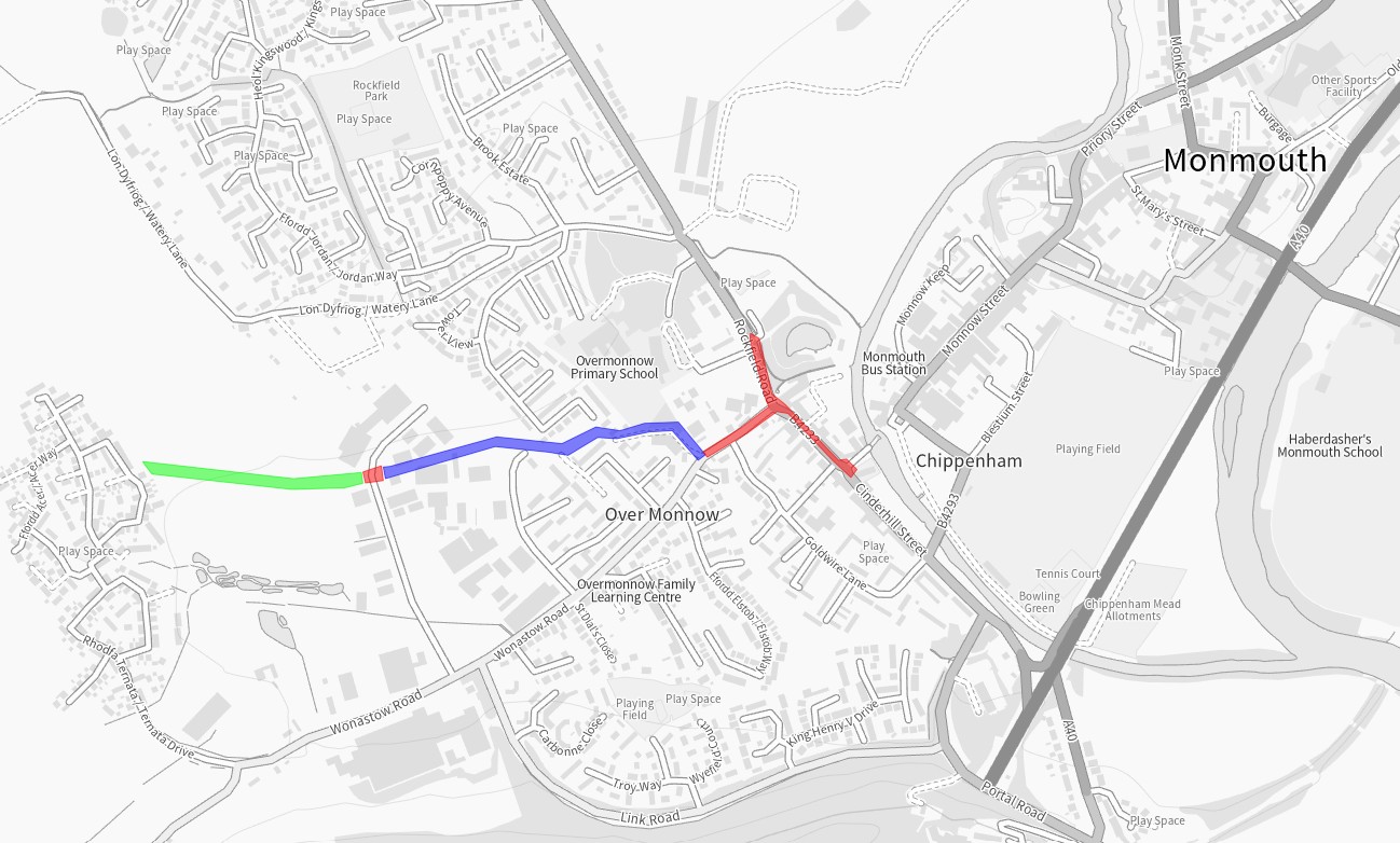
The scheme was divided into phases:

WFL AT scheme on map
  • Provide a coherent, direct, comfortable, and attractive walking and cycling network from Overmonnow to surrounding communities, services, and facilities across Monmouth;
  • Increase levels of sustainable access to employment, health, education, and services;
  • Positively impact actual and perceived pedestrian, cyclist, and wheelchair user’s safety along and across the study area;
  • Support modal shift in Monmouth towards more sustainable forms of transport;
  • Reduce the negative impacts of transport on the natural and built environment.

The need for an improved route to Overmonnow Primary School was first recognised during Monmouthshire County Council’s Active Travel Integrated Network Map (INM) submission to the Welsh Government in 2018. Wonastow Road is an arterial route into the town and industrial area for vehicle traffic, but providing active travel routes in the area was challenging due to the legacy road layout, lack of footway and width in some sections, and a ditch/culvert that runs along the side of the road. A public right of way running between Kings Fee, Overmonnow, and St Thomas Road, Drybridge, offered a route away from sometime heavy vehicle traffic, but was a dirt path that was dark and inaccessible at times.

The housing development at Kingswood Gate has been one of the key drivers for changes being proposed, responding to local population growth by supporting modal shift and reducing pressure on local highway network. Walking, wheeling and cycling provision have a significant role to play in mitigating vehicle congestion, pollution, and health and wellbeing issues related to car-dependent lifestyles.

Funding for the various elements of this scheme has been granted from the Welsh Government Active Travel Fund, Safe Routes in the Communities (SRiC) fund as well as Section 106 monies from local developments.

Constructed 2025

The Kingswood Gate housing estate lies to the West of Overmonnow Primary School and was built circa 2016 and contains over 300 houses. The estate is connected by road to Monmouth by Wonastow Road. This road has poor pavement infrastructure with no scope to improve sections, high levels of HGV movement with the local industrial estate and a lack of active travel infrastructure. There is little potential to improve this corridor, due to the proximity of roadside culvert and neighbouring properties. The pedestrian route provided with the development of the estate was not sufficiently accessible or direct, and the Section 106 funding from the estate set aside for development of the preferred ‘desire line’ route across the Kingswood Gate meadow proved insufficient to complete the path. MCC therefore developed the path using successive rounds of funding from the Welsh Government’s Active Travel Fund (in addition to the Section 106) and, in 2025, £338,000 construction funding was secured by MCC from Welsh Government Safe Routes in Communities (SRiC) Fund.

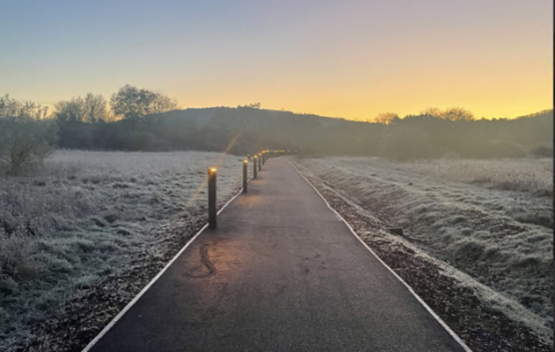
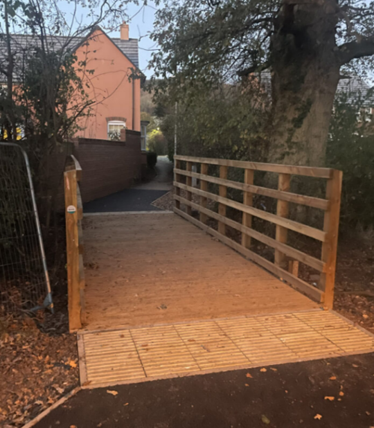
This phase of the scheme has taken longer to complete than originally planned. Land ownership, changing the alignment of the Public Right of Way, sensitive ecology, flooding and funding cycles have all been factors in increasing the time the process took. The path was opened for use in November 2025.

The scheme includes:

  • A 3 metre-wide walking, wheeling and cycling path
  • A culverted crossing over the ditch from the meadow into Kingswood Gate estate (West end of the meadow)
  • Sustainable Urban Drainage (SUDs) features for ground water management along the length of the path
  • Biodiversity-friendly low-level lighting
  • Connection to the already constructed Wonastow Industrial estate crossing and the Williamsfield Lane path.

Walking and cycling data will be collected over the next couple of years to help build a picture and show trends of usage of the route. The Williams Field Lane section of the route saw increased use after its installation and continues to show good usage and obvious trends that people are using the route to go to and from school or a place of work. With the addition of the new Kingswood Gate section to this route it will allow even more people to choose to walk or cycle into Monmouth. The completed route connects directly to the crossing in Wonastow Industrial Estate, on to Williamsfield Lane and finally joins the  Wonastow Road/Drybridge Street active travel paths, creating a continuous, direct and comfortable route for walking, wheeling and cycling between Kingswood Gate and the centre of Monmouth.

Constructed in 2024

This phase of the scheme focussed on Wonastow Road, Drybridge Street and Rockfield Road and creating a connection between the Phase 1 Williams Field Lane and the Monnow Bridge. It provides improved access to Bridges Community Centre, Monnow Vale Hospital and the facilities and services within the town centre and beyond such as the leisure centre and Comprehensive School. It also provides a connection from the MCC free car park and Rockfield Road skatepark to the town centre.

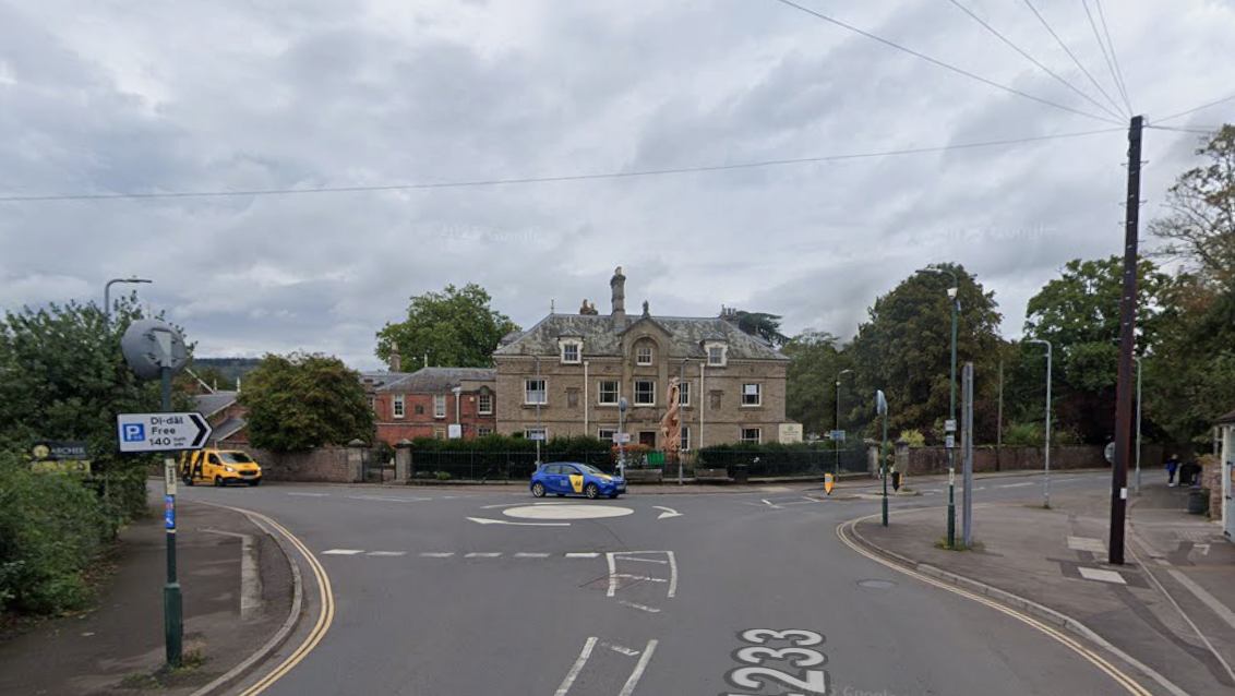
Historically the roads in this area have a lot of traffic including large lorries accessing the Wonastow Industrial Estate. The road layout which included a painted mini roundabout allowed vehicles to move at speed even after the 20mph restriction was brought in. Together these issues alongside narrow pavements and poor provision for crossing the road made the area feel unsafe and uninviting for those walking and wheeling.

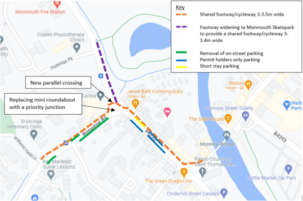
The scheme included:

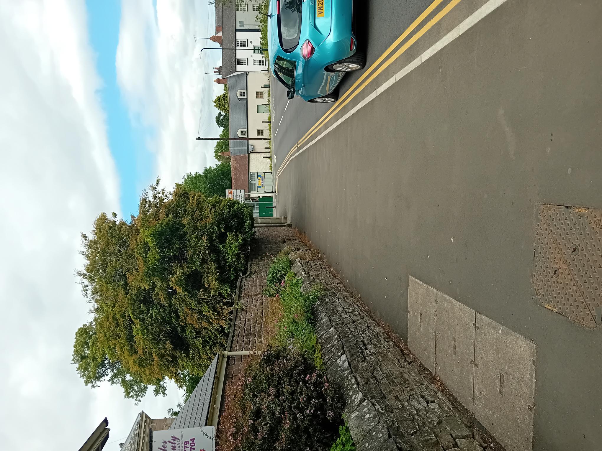
  • Widening the existing footway on the northern side of Wonastow Road to accommodate a shared-use footway/cycleway.
  • Replacing the existing Wonastow Road/Drybridge Street/Rockfield Road mini-roundabout with a priority junction (T-junction).
  • Providing a parallel crossing (like a zebra crossing but with a lane for cycling) on the Rockfield Road junction arm
  • Providing an informal crossing (dropped kerb and tactiles) on the side road arm of the junction (Wonastow Road).
  • Widening the existing footway on Rockfield Road from the new priority junction to Monmouth skatepark.
  • Widening of a short section of the existing footway along Drybridge Street near the Monnow Bridge roundabout
  • Removing sections of on-street parking along Wonastow Road to deliver the route in line with the Active Travel Act Guidance.
  • Providing a parallel crossing across Wonastow Road Industrial Estate Road
Image: Scheme proposal for Williamsfield Lane to Monnow Bridge 

Also as part of this phase of works, a parallel crossing (like a zebra crossing, but with a lane for cycling) was installed across the Wonastow Industrial Estate road, as this road carries large vehicles. This crossing is key in linking the Kingswood Gate path to the Williams Field Path and give those who walk, wheel and cycle a place to cross.

Constructed in 2022

The first phase of the scheme was the Williams Field Lane path. The path links multiple housing estates allows for direct, safe access to Overmonnow Primary school, the town centre and other facilities. Constructed in 2022, the scheme provided a 3m wide walking, wheeling and cycling route from the Wonastow Industrial Estate through to where Williams Field Lane connects with Wonastow Road. The route replaced a well-used but muddy track and primarily allowed for much safer access to Overmonnow Primary School whilst benefitting wider network connections to the town centre. The path features low-level lighting, designed to minimise impact on bats and other local wildlife. As a joint effort between MCC departments, a play park in Kings Fee was also constructed as part of this route phase.  The play park, built either side of the path, allows for “play along the way” as well as an outdoor education space for Overmonnow Primary School. This section of the route was recognised in May 2025 as a benchmark for other Active Travel and “play along the way” schemes across Wales – https://www.monmouthshire.gov.uk/2025/05/monmouthshire-county-council-will-use-funding-to-improve-play-areas/ 

Data on route usage is gathered to monitor impact and usage trends. In the 3 years the route has been in place the data has showed an increase of traffic at peak times, giving evidence that the route is being used for ‘purposeful journeys’ such as getting to school or a place of work.

There is a short, narrow section running between two large industrial premises just off Wonastow Industrial Estate Road. Whilst the path still allows access, it is narrow and anyone wheeling or cycling along that section should exercise caution and look out for other users. Currently plans to widen this section are on hold due to the prioritisation of other schemes.

This route has been monitored for walking, wheeling and cycling usage throughout its development. The data shows a trend of increased use at weekday school-times, which suggests the route is useful for purposeful journeys, such as trips to school and work, in addition to leisure journeys. Through anonymised data collection, path usage is monitored to measure the impact of route improvements. 

Image: Data collection shows trends in path usage

For more information on MCC’s work on active travel in Monmouth, please visit Monmouth – Monlife


Let’s Move for a Better World

Let’s Move for a Better World

Support the fight against sedentary lifestyles by joining the biggest social movement campaign in the fitness industry. Get ready to donate moves from 14th to 31st March 2023.

By taking part in the ‘Let’s Move for a Better World’ Campaign, you commit to fight against physical inactivity and all the consequent health diseases contributing to build a better and healthier world. To give everyone the same chance and opportunity, irrespective of age, sex and level of physical ability, Technogym have created the ‘MOVE’, a new way to measure physical activity that connects the whole community.

With only 30 minutes of physical activity 5 days a week, you reduce the risks associated with obesity and chronic diseases, whilst at the same time reaching other important goals.

Join our Challenge

This March, MonLife are teaming up with Technogym to get Monmouthshire moving. We have set up a ‘MOVEs’ challenge via the ‘MyWellness’ App (available on both the App Store and Play Store) for everyone to join and take part in! All you have to do is complete 2000 MOVEs.

You can complete the challenge in the gym, outdoors or our spin classes. All members that participate will enter a raffle for the chance to win a 12-month membership. Additionally, all members that collect 5000 ‘MOVEs’, will enter a raffle to win ‘Let’s Move’ merchandise.

How to Collect ‘MOVEs’

The Technogym® MOVE is based on body displacement in space, therefore it offers the best means to measure and compare participants’ activity levels during the Campaign. The faster and more often you move, the more ‘MOVEs’ you collect. Here’s how you can collect your ‘MOVEs’:

  • – Indoor Automatic on cardiovascular equipment within MonLife Leisure Centres (i.e., Treadmill, Bikes, Vario, Syncro, Climb, Skill line, Group Cycle)
  • – Indoor Automatic on connected resistance equipment within MonLife Leisure Centres (i.e., Chest Press, Leg Press, Shoulder Press).
  • – The Mywellness App Outdoor GPS Activity Tracker
  • – 3rd Party Devices with GPS connectivity (e.g. – Garmin). Please note Fitbit and Apple watches do not offer this.

Win for your community

The facilities that gather the required number of ‘MOVEs’ will be able to donate equipment to the Institutions or Schools of their choice to help fight obesity and sedentary lifestyles.

Let’s Engage your community to create a healthier world!