Caldicot Active Travel Links and Multi-User Route
The Caldicot Links active travel scheme is designed to create an integrated network of shared use routes, linking existing and planned residential areas around east Caldicot to local destinations and public transport. The aim is to enable residents to use active travel for local trips and to connect to the wider Severnside active travel and public transport networks, through the construction of high quality and accessible routes for walking, wheeling and cycling.
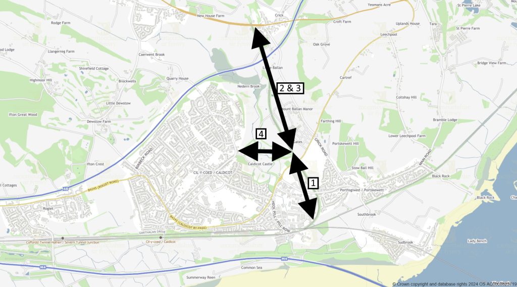
Caldicot Active Travel Links scheme
Caldicot Links scheme focuses on the north and east of Caldicot. The scheme is in three sections* (see plan below):
- Phase 1: Running along the route of the old ex-Ministry of Defence Dinham railway line, from just south of the Cornfield at Portskewett, to level with Caldicot Castle Country Park.
- Phases 2 & 3: From level with the country park northwards to Crick, crossing the northeast Caldicot RLDP sites.
- Phase 4 – Multi User Route: Running through Caldicot Castle Country Park connecting up with the Caldicot Links and the B4245 at its eastern end and linking into Church Road (and on to Caldicot Town Centre) at its western end.
*Sections of the scheme are being brought forward as funding and other constraints permit, i.e. not necessarily in numerical order.
Current progress
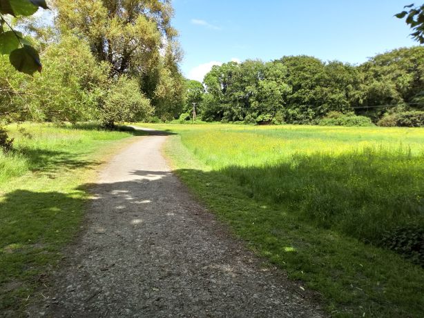
Phase 1: Construction completed providing an approximately 1km long tarmac surfaced shared route open to the public.
You are welcome to use this section of the new Caldicot Links active travel route for walking, wheeling, and cycling. Please note that this route is not being promoted as accessible to all users at this time and represents the first stage in delivering a complete connection from Portskewett to Caldicot.
Please note the following:
- Caldicot Castle Country Park: There is currently no formal hard-surfaced path connecting this tarmac path to the Country Park tarmac service road. Users wishing to continue into the Country Park will need to use informal grass paths, which have uneven surfaces, slopes, and gates.
- Elderwood Parc: There is no onward connection from the top of the ramp into Elderwood Parc due to the housing development still being under construction.


Picture: The new Caldicot Links Phase 1.
Phases 2 & 3: MCC appointed consultants have undertaken a study of the options available for developing the route north and east of the Country Park, considering the key opportunities and the constraints of this area. Further scheme progression is dependent on the future development of the RLDP sites adjacent to it and funding availability.
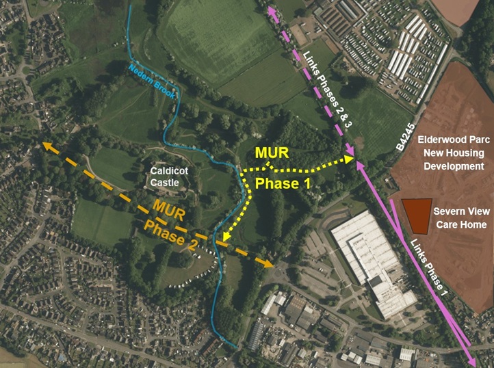
Phase 4 – Multi User Route (MUR): This phase has now been split into two sub phases (see plan below) to aid development.
MUR Phase 1 connecting up the northern end of the completed Links Phase 1 with the existing tarmac service road running through Caldicot Castle Country Park, via a new hard surfaced shared use path.
A public consultation on the scheme proposal took place throughout August 2025 which demonstrated good community engagement, interest and support for the MUR Phase 1. It also identified key elements that would improve the scheme for users, that have been incorporated into the design where possible.
A summary of the consultation results can be found here.
The full consultation report is available here.
The scheme is now in the construction stage, that is currently planned to run from late March/April until the end of June 2026.
For the safety of Caldicot Castle Country Park users it will be necessary to temporarily close some parts of the country park during the works (along the MUR Phase 1 route and the temporary works compound). More details will follow via this webpage and on-site signage.
Visualisations of the scheme design can be seen on a separate project webpage.
MUR Phase 2 running west-east through the country park from the western entrance off Church Road to the eastern entrance and connection with the B4245. Initial assessments have been undertaken but there is currently no funding available to progress the design.
Why focus on north and east Caldicot?
This scheme looks to improve sustainable access to services, shops, and sites of education and employment around Caldicot. Trip generation related to the planned residential development to the east and north of Caldicot, as well as the need to mitigate congestion related to local employment sites and the newly toll-free Severn bridges gives extra impetus to the scheme, as this is an opportunity to make active travel the preferred mode for local trips for old and new residents alike. It also has added value of providing an attractive route for recreational activities and providing improved access to local community green spaces, such as Caldicot Castle and Country Park and the Cornfield Project, as well as to the Wales Coast Path and the wider Gwent Levels Landscape of Outstanding Historic Interest.
The phased Caldicot Links scheme focuses on the east of Caldicot, including linking to housing developments off Church Road and Crick Road, to ensure that current and future residents have accessible, healthy and sustainable transport options, to minimise and manage the road traffic impact of a growing population and to direct residents and visitors into the town centre as a local destination.
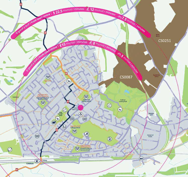
Below is a detail of our Active Travel Map for Caldicot, showing the time it would typically take to travel in the local area. The local development areas, shown in brown, will include parcels of green space (i.e. the indicated sites include areas that will not be built up):
What is active travel?
Active travel is a term used to describe walking, wheeling or cycling to a destination, which the Active Travel Act (Wales) 2013 calls “purposeful journeys”. It does not cover trips taken purely for leisure although it could significantly enhance leisure activities by helping to link up networks. Active travel can be used to get to school, work, services and shops, or as one of several modes on a longer journey – for example, walking to the station to catch a bus or train. Monmouthshire County Council (MCC)’s active travel strategy focuses on journeys of three miles or less, which means improving walking and cycling infrastructure within communities and between close-by settlements such as Caldicot, Portskewett and Crick, so that active travel can be the natural choice for local journeys. MCC also aims to improve active travel links to public transport, to support sustainable travel across the county.
How is the Caldicot Links scheme funded?
The Caldicot Active Travel Links and Multi-user routes project development and construction works to date have been funded by Welsh Government grants aimed at improvements to sustainable transport modes.
Contact us
If you would like to contact the project team, please email ActiveTravel@monmouthshire.gov.uk
For more information on MCC’s work on active travel in Caldicot, please visit Caldicot – MonLife
This post is also available in: