Active Travel in and around Chepstow
Monmouthshire County Council (MCC) is working on active travel routes across Chepstow to better connect residents to local destinations and public transport services. We aim to improve equity of access to education, employment, local shops and services, to support sustainable, resilient and connected communities in the Chepstow area and across Monmouthshire.

Image: Covered cycle parking at Chepstow Drill Hall
Like many historic and hilly towns, Chepstow has obstacles to easy walking, wheeling, and cycling:
- Steep gradients and narrow footways
- Busy roads and junctions, particularly along the A48 and A466
- Historic streets and older infrastructure, not designed with modern traffic volumes or active travel in mind
- Air quality issues linked to strategic road routes through the town
With new housing proposed in Chepstow, Caldicot, and nearby areas of Gloucestershire—including Beachley, Sedbury, and Lydney—local travel demand is expected to increase. This makes it more important than ever to create safer, more accessible options for short everyday journeys.
Developing the Active Travel Network Map
Routes in Chepstow have been included in the Welsh Government’s Active Travel Network Map (ATNM). This map shows designated routes that form a walking, wheeling and cycling network in built up areas. Routes must be improved where necessary to pass audit as suitable for active travel journeys. These are not leisure paths or recreational trails, but routes designed to support safe and accessible daily travel —such as to schools, workplaces, shops, or health services.
MCC identifies key active travel projects across the county and applies for funding to deliver them. This funding comes mainly from Welsh Government programmes and is allocated for specific schemes. It must be secured through a competitive bidding process and can only be spent on the projects it is awarded for. This ensures investment is targeted, accountable, and delivers the greatest benefit for residents.
Levelling Up Fund Investment in Chepstow
MCC secured funding from the UK Government’s Levelling Up Fund (LUF) to enhance sustainable transport facilities in Chepstow—including improvements to rail, bus, and active travel links. This funding will be divided between projects, with active travel interventions designed around the portion of funding available.
The Levelling Up bid primarily focused on improving Chepstow’s public transport interchange at the railway station, helping to create a more efficient and accessible rail and bus experience.
The project also includes active travel enhancements to connect the transport hubs with surrounding communities, making it easier for people to complete onward journeys by walking, wheeling, or cycling.
Chepstow Active Travel priorities
MCC has worked on the ATNM with Chepstow Town Council and stakeholder groups to develop a list of active travel priorities for Chepstow.
Chepstow active travel priorities – Background
Following the development of the ATNM, a series of studies looked at the main active travel ‘corridors’ in Chepstow. In preparation for the LUF investment in November 2024, Chepstow Town Councillors asked to review current stakeholder priorities and to contribute to the selection, design and prioritisation of active travel proposals for the town. For this, MCC commissioned consultants AtkinsRéalis to develop new design proposals aimed at improving walking, wheeling and cycling access across Chepstow.
Chepstow Active Travel Improvement Study
In 2025, AtkinsRéalis carried out a detailed study of Chepstow’s key active travel corridors, funded by the Welsh Government’s Active Travel Fund. Their work included:
- Review of earlier WelTAG assessments undertaken by Sustrans and ARUP in 2022
- Engagement with stakeholders through workshops and co‑creation sessions
- Site visits to understand existing challenges, topography, and movement patterns
- Analysis of consultation feedback from residents, community groups and elected members
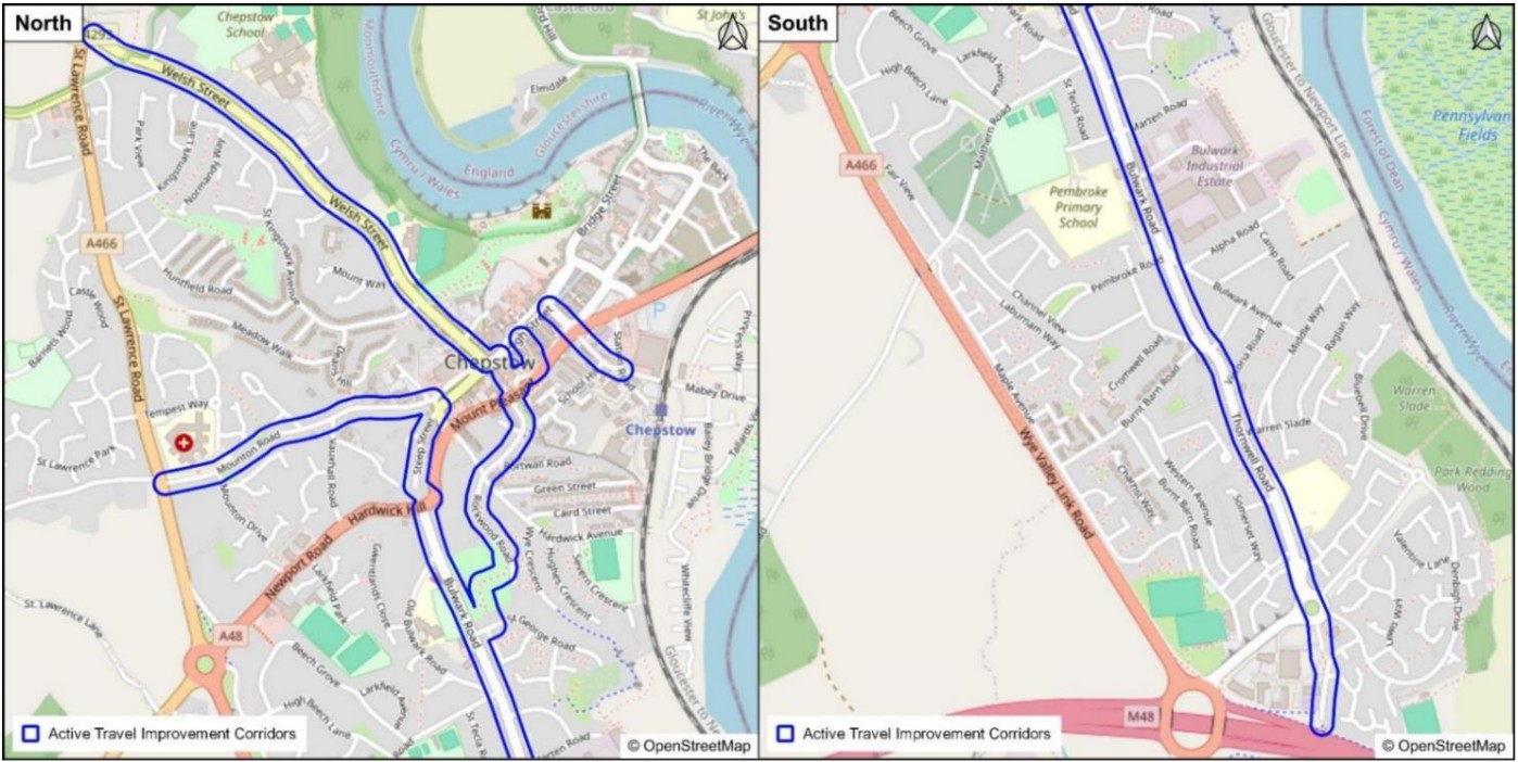
Image: AtkinsRéalis Chepstow active travel improvement study – Study area
Priority Active Travel Corridors
The study focuses on six priority corridors in Chepstow, identified as offering the greatest potential for improved active travel connections:
- Welsh Street Corridor – Connecting the roundabout at St Lawrence Road/Itton Road to The Town Gate signal junction (junction excluded).
This corridor serves Chepstow School and the Leisure Centre. - Station Road – Linking the area around Chepstow Railway Station to the High Street via the underpass.
- Upper Nelson Street – Connecting the Palmer Centre area to the High Street.
- Garden City Way – From the A48 junction to St George Road near Bulwark Park, passing through Bulwark Park.
- Mounton Road – Connecting Thomas Street to the A466, including access to Chepstow Community Hospital.
- Steep Street to Caerwent Lane – A key town‑to‑Bulwark active travel link.
Consultation on Active Travel in Chepstow
MCC has held public consultations on the active travel network map in Chepstow. Following this, the Sustrans and Arup WelTAG reports also included stakeholder consultation. A wide range of local stakeholders contributed to the most recent study, including Chepstow residents, Transforming Chepstow Delivery Group, community groups, Transition Chepstow, Town and County Councillors and MCC Officers. Their local knowledge and feedback helped shape the design priorities and identify key opportunities for improvement.
Next steps for Active Travel in Chepstow
Following the consultation and concept design work carried out in summer 2025, priority schemes have now been identified for more detailed development.
Further technical assessments and detailed design work will be required before any construction can take place and designs may still change based on technical requirements, funding availability, and ongoing consultation.
Over the coming months, MCC will carry out technical surveys of sites, develop detailed designs for shortlisted active travel improvements, assess each proposal against available funding, construct prioritised and deliverable interventions.
This process ensures that the most effective, achievable and beneficial improvements are progressed first. Once the designs are complete and approved, MCC will share the updated plans. Further opportunities for feedback will be provided as the projects move toward construction.
Pwllmeyric ‘Puffin’ crossing
Monmouthshire County Council proposes to install a signal-controlled crossing in Pwllmeyric, at this location. This crossing would be for the benefit of people taking buses 73, 74, X74 and T7, as well as for local children getting to school in Chepstow and anyone walking to the shops and services in Chepstow.
This plan is subject to funding. A crossing is needed for walking between Chepstow, Mathern and Pwllmeyric, as there is only a footway on the northside of the A48 between Pwllmeyric and Chepstow, and there is no accessible crossing point at all along the A48 within Pwllmeyric village.
The proposed ‘puffin’ crossing would be located on the A48 in Pwllmeyric between the Brynderwen Lane bus stops, just west of the Bayfield Road/ Mounton House turning(External link). The local walking routes, traffic speed and volume, bus stops, sightlines, side roads and driveways have been taken into account in the crossing design. A Puffin crossing consists of traffic lights and a push-button display for people wanting to cross.
Public consultation on the crossing proposal (in May 2026) found that, from comments that came largely from postcodes local to the crossing,
65% stated specific support for the crossing. Comments noted the volume of traffic and other problems that make crossing the A48 in Pwllmeyric difficult at present. An additional 7% supported the idea of a crossing but preferred a different location, and 15% supported the idea of a crossing but had concerns about the proximity to the speed limit change zone, known traffic speeds in the area, existing surface quality and whether this crossing was needed.
- Location: This location was selected as it is at the top of the hill, so vehicles heading west have not yet picked up momentum going downhill through the village, and vehicles heading east will be coming up-hill and have less momentum. This would not be the case if a crossing were placed at the west (downhill) end of the village. The location is also the closest possible place to cross for the Public Right of Way (PROW), with driveways and junctions negating any other any location further west within the village, near the PROW. The location allows crossing between the bus stops (for return journeys) and crossing onto the only footway towards Chepstow, for people walking through Pwllmeyric via the A48 and Chapel Lane.
- Speed limit change proximity and traffic speeds in the area: The crossing type and location have been recommended based on actual traffic speeds at the location. In recognition of the speed limit zone, the 30mph zone rumble strips will be refreshed, and anti-skid surfacing will be added near the crossing. The crossing signal-heads and white lines will affect driver behaviour further. Once installed, monitoring will allow us to assess if further measures need to be considered.
- Surface quality: The road surface will be assessed.
- Need for a crossing and potential to cause network congestion: There is no accessible crossing in Pwllmeyric. Furthermore, the response to the consultation shows that people see the need for a crossing. Potential traffic congestion has been considered as negligible and should be weighed against accessibility of walking routes.
13% of responses were negative, giving reasons such as:
- A crossing is not needed: See above ‘Need for a crossing’.;
- There are larger problems in the area that the crossing does not address: Funding available is for active travel measures, and the existence of other problems does not negate the need for a crossing;
- Concern over risk created by re-design/crossing installation: The design has been based on actual traffic speeds and network vehicle mix at the location, taking into account sight-lines and turning movements.
Concerns raised in the consultation have been or will be mitigated, and the overall response to the proposed design has been positive.
Chepstow Active Travel Locality Map
Click on the map to enlarge or download it.
This post is also available in: