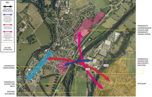
Monmouth Wye Active Travel Bridge & Links
Monmouthshire County Council (MCC) is working on a strategic scheme to improve active travel provision between Monmouth and Wyesham. This scheme focuses on providing a new walking and cycling bridge, upstream of the Wye Bridge between Monmouth and Wyesham, with onwards routes to the centre of both communities. The new bridge will provide a main route to Monmouth town centre and secondary school for Wyesham residents, and across the Monmouth School campus, split between both sides of the river.
What is the change we expect to see?
- Improved connectivity and accessibility for active travel trips in and between Monmouth and Wyesham
- Improve actual and perceived levels of personal safety and security when walking and cycling
- Promotion of sustainable travel as attractive and safe in Monmouth and Wyesham.
Identified issues for active travel between Monmouth and Wyesham
Monmouth’s historic Wye Bridge provides a vital link between Wyesham, the Forest of Dean and the Wye Valley, and the town of Monmouth and the A40, a strategic road link between South Wales and England’s Midlands. The roads that feed traffic across the bridge carry heavy vehicles and high traffic volumes, as this is the main river crossing for several miles in either direction. This impacts on routes either side of the bridge, and the scheme was eventually split into three sections, the Monmouth Wye Active Travel Bridge, Old Dixton Road and Wyesham Links.
The community of Wyesham suffers restricted and difficult access to the secondary school, shops and services in Monmouth because the existing infrastructure around the A40 and the River Wye effectively cut it off. The bridge is used daily by residents of Monmouth, Wyesham and the Forest of Dean to commute to work or school on both sides of the river. Local trips by vehicle must use a circuitous one-way system, in a network that is vulnerable to congestion, but the historic bridge does not provide a safe or pleasant route for short trips without a car, especially for those using wheelchairs and mobility scooters or walking with pushchairs or small children. Cycling is not permitted on the footway, but there is no provision for cyclists to transition between the underpass path and the road where needed.
The Wye Bridge in Monmouth is a Grade II listed building, protected for its historical and architectural significance. An assessment of the road bridge found it unsuitable as an active travel route. The pavement is narrow and heavy goods vehicles often mount the pavement due to the narrow carriageway, and its structure cannot be altered due to its heritage status.

The full scheme looks to:
- Construct a single-span 3.8m-wide walking and cycling bridge upstream of the existing Wye bridge with low-level lighting
- Provide connecting routes in Wyesham and Old Dixton Road on either side of the active travel bridge
- Provide a coherent, direct, safe, comfortable, and attractive walking and cycling link between Wyesham and Monmouth
- Positively impact actual and perceived pedestrian, cyclist, and wheelchair user’s safety along and across the study area
- Ecology net gain
Monmouth Wye Active Travel Bridge
A separate pedestrian and cycle bridge over the River Wye in Monmouth was initially proposed as a recreational route. Following the Welsh Government’s Active Travel Act and recognition of this crossing’s function for active travel journeys as well as for recreation, the idea was developed under Monmouth Town Council’s Active Travel Group working party ‘The Bridge Group’, with stakeholders including Monmouth County Council, Monmouth School for Boys, Monmouth Comprehensive School, local Primary Schools, local rowing, cycling and walking clubs and Sustrans.
In 2019 a Weltag study was carried out to investigate the current issues and find potential solutions to them. The report suggested several options including, widening the current pavement, adding a cantilever footway to the existing bridge as well as a new walking and cycling bridge. The option of building a separate walking and cycling bridge upstream of the historic Wye bridge was selected as the best option to take forward based on scoring of the proposal’s potential positive impact on active travel and the local transport network, minimal negative impact during construction and on the nearby heritage bridge, value for money and deliverability.
Bridge scheme development

Between 2020 and 2024, following the WelTAG study, MCC used Welsh Government’s Active Travel Fund to develop the design of the bridge and linking routes either side of the river, alongside the necessary planning permission, ecological studies and permissions, and land surveys as well as development of the Wyesham links and Old Dixton road schemes which form the onwards connections either side of the proposed bridge. Restricted funding and land issues has meant that progress has been slower than desired. In early 2024 the Wye Active Travel Bridge received planning permission with conditions.
A video of the proposed bridge can be seen here:
MCC used ATF Core Funding to maintain progress on this scheme in 2024-25. This included ecology surveys and monitoring, land negotiation, category II checks (independent examination of design) Early Contractor Involvement (ECI), and detailed design of the works and ‘pre-works’ (i.e. works needed to prepare the site, such as access routes and moving of utilities). The scheme has been put forward to the Cardiff Capitol Region’s Regional Transport Plan as one of Monmouthshire’s strategic Active Travel schemes.
Wyesham Links
Objectives of the Wyesham Links scheme
- Provide a direct, coherent, comfortable and attractive walking and cycling network suitable for all users
- Increase levels of sustainable access to education, employment health and other key services
- Improve actual and perceived safety of vulnerable users
- Increase the number of people walking and cycling between Wyesham and Monmouth town centre
- Reduce car dependency and car use for short trips between Wyesham and Monmouth town centre through a modal shift
- Reduce the negative impacts of transport on the natural and built environment
Identified Issues in Wyesham
- High traffic volumes, with a significant proportion of heavy good vehicles, and high traffic speeds, related to the nearby dual carriageway and feeder roads, and lack of adequate provision for using alternative modes for short, local trips.
- Lack of pedestrian crossing facilities and pinch points on the existing footway
- Side road junctions are wide and require tightening of junction radii to reduce conflict with vulnerable road users
- Dropped kerbs and tactile paving required at some side road junctions;
- Lack of wayfinding and signage
Proposed Interventions – Wyesham Links
A series of studies of route usage and potential interventions in the Wyesham area led to the concept development of pedestrian only footway from the Mayhill Roundabout up the junction of Wyesham Road and Wyesham Avenue, with cycling provision to be made on road using the Quiet Streets principle, then, from Wyesham Avenue and Wyesham Road junction to Kymin View Primary School, a shared use facility utilising the potential generous footway widths along this section.
Image: Design concept plan for Wyesham Links scheme
Old Dixton Road scheme
Objectives of the Old Dixton Road scheme
The proposed active travel route will run from Monmouth Library along the A466 to where it joins with Old Dixton Road, east along old Dixton Road for circa 250m and thereafter heading through the subway under the A40 to Monmouth Rowing Club where it will join with an existing path that runs north east alongside the river.
- Increase the number of active travellers in Monmouth by making the route along Old Dixton Road and from the Wye bank better suited and more attractive to pedestrians and cyclists
- Improvements at key junctions and crossing points
- Deliver environmental improvements for the area by encouraging mode shift from cars to active modes, reducing vehicle waiting, improving vehicle flows and infrastructure to make the route more attractive and reducing car traffic
Identified Issues in Old Dixton Road/ around Monmouth Comprehensive School
Congested, historic road infrastructure and narrow footways create an unattractive and incoherent route for active travel. Improvements have been made to the area with the construction of the new school and leisure centre buildings, but poor footway provision and restricted widths near the Nags Head pub still create issues for active travel along the route.

Proposed Interventions – Old Dixton Road
The scheme proposes small-scale improvements to active travel provision along Old Dixton Road from Monmouth Library and Hub to the underpass to the River Wye, to maintain and increase levels of walking and cycling to the Comprehensive school, Leisure centre, other businesses and community facilities served by the route.
For more information on MCC’s work on active travel in Monmouth, please visit Monmouth – Monlife